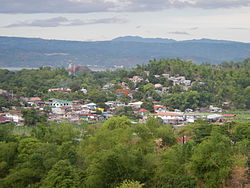
Cardona, Rizal
Cardona | |
|---|---|
| Municipality of Cardona | |
 | |
 Flag  Seal | |
 Map of Rizal with Cardona highlighted | |
OpenStreetMap  | |
 Cardona Location within the Philippines | |
| Coordinates: 14°29′10″N 121°13′44″E / 14.4861°N 121.2289°ECoordinates: 14°29′10″N 121°13′44″E / 14.4861°N 121.2289°E | |
| Country | Philippines |
| Region | Calabarzon |
| Province | Rizal |
| District | 2nd district |
| Founded | February 1, 1914 [1] |
| Barangays | 18 (see Barangays) |
| Government | |
| • Type | Sangguniang Bayan |
| • Mayor | Teodulo C. Campo |
| • Vice Mayor | Gil F. Pandac |
| • Representative | Juan Fidel Felipe F. Nograles |
| • Municipal Council | Members |
| • Electorate | 29,006 voters (2019) |
| Area | |
| • Total | 28.56 km2 (11.03 sq mi) |
| Elevation | 29 m (95 ft) |
| Highest elevation | 242 m (794 ft) |
| Lowest elevation | 0 m (0 ft) |
| Population (2020 census) [4] | |
| • Total | 50,143 |
| • Density | 1,800/km2 (4,500/sq mi) |
| • Households | 11,089 |
| Economy | |
| • Income class | 3rd municipal income class |
| • Poverty incidence | 10.12% (2015)[5] |
| • Revenue | ₱161,307,897.02 (2020) |
| • Assets | ₱341,313,439.62 (2020) |
| • Expenditure | ₱149,518,247.70 (2020) |
| • Liabilities | ₱92,341,082.88 (2020) |
| Service provider | |
| • Electricity | Manila Electric Company (Meralco) |
| Time zone | UTC+8 (PST) |
| ZIP code | 1950 |
| PSGC | |
| IDD : area code | +63 (0)2 |
| Native languages | Tagalog |
| Website | www |

Cardona, officially the Municipality of Cardona (Tagalog: Bayan ng Cardona), is a 3rd class municipality in the province of Rizal, Philippines. According to the 2020 census, it has a population of 50,143 people. [4]
Cardona is part of the 2nd Congressional District of Rizal.
Located about 42 km east of Manila. With the continuous expansion of Metro Manila, the municipality is now part of Manila's conurbation which reaches Cardona in its easternmost part.
In 1855, Cardona became a town with boundaries set in 1857. Later in June 1901, Cardona formed part of the newly created Province of Rizal through Act 137 promulgated by the Philippine Commission. In 1903, a succeeding Act annexed the town to the Municipality of Morong. Eleven years then, the Executive Order 108 issued by Governor General Francis Burton Harrison has established the town as an independent municipality.
Etymology[]
An oral folklore tells how the name “Cardona” was derived from the Spanish word “caldo” referring to a native rice broth. Supposedly, a stranger walking through the street of the town happened to ask the name of the town from a native, who at that time was enjoying a bowl of hot “caldo”. Thinking that the stranger was inquiring as to what he was eating, the native answered “Sapao! Caldo!”
Another story tells that the town of Cardona in Barcelona Province is believed to be the eponym of the town. Settlements in the area during the Spanish-era were on the hills and the place surrounded by waters of the Laguna Lake. Early missionary Franciscan friars have seen its resemblance to the Spanish town which is also located on a hill and is almost surrounded by the waters of the river Cardener. Parts of the present-day Barangays Calahan, Patunhay, Del Remedio, Iglesia, San Roque, Dalig, and Looc are set on these hills.
Barangays[]
Cardona is politically subdivided into 18 barangays, [6] 11 of which are on the mainland and 7 on Talim Island.

- Mainland
- Calahan
- Dalig
- Del Remedio
- Iglesia
- Looc
- Nagsulo
- Patunhay
- Real (Poblacion)
- Sampad
- San Roque (Poblacion)
- Ticulio
- Balibago
- Boor
- Lambac
- Malanggam-Calubacan
- Navotas
- Subay
- Tuna
Climate[]
| Climate data for Cardona, Rizal | |||||||||||||
|---|---|---|---|---|---|---|---|---|---|---|---|---|---|
| Month | Jan | Feb | Mar | Apr | May | Jun | Jul | Aug | Sep | Oct | Nov | Dec | Year |
| Average high °C (°F) | 26 (79) |
27 (81) |
29 (84) |
31 (88) |
31 (88) |
30 (86) |
29 (84) |
29 (84) |
29 (84) |
29 (84) |
28 (82) |
26 (79) |
29 (84) |
| Average low °C (°F) | 22 (72) |
22 (72) |
22 (72) |
23 (73) |
24 (75) |
25 (77) |
24 (75) |
24 (75) |
24 (75) |
24 (75) |
24 (75) |
23 (73) |
23 (74) |
| Average precipitation mm (inches) | 58 (2.3) |
41 (1.6) |
32 (1.3) |
29 (1.1) |
91 (3.6) |
143 (5.6) |
181 (7.1) |
162 (6.4) |
172 (6.8) |
164 (6.5) |
113 (4.4) |
121 (4.8) |
1,307 (51.5) |
| Average rainy days | 13.4 | 9.3 | 9.1 | 9.8 | 19.1 | 22.9 | 26.6 | 24.9 | 25.0 | 21.4 | 16.5 | 16.5 | 214.5 |
| Source: Meteoblue (Use with caution: this is modeled/calculated data, not measured locally.) [7] | |||||||||||||
Demographics[]

In the 2020 census, the population of Cardona, Rizal, was 50,143 people, [4] with a density of 1,800 inhabitants per square kilometre or 4,700 inhabitants per square mile.
| Year | Pop. | ±% p.a. |
|---|---|---|
| 1903 | 2,580 | — |
| 1918 | 3,278 | +1.61% |
| 1939 | 6,366 | +3.21% |
| 1948 | 8,134 | +2.76% |
| 1960 | 12,476 | +3.63% |
| 1970 | 16,880 | +3.07% |
| 1975 | 21,266 | +4.74% |
| 1980 | 24,503 | +2.87% |
| 1990 | 32,962 | +3.01% |
| 1995 | 35,501 | +1.40% |
| 2000 | 39,003 | +2.04% |
| 2007 | 44,942 | +1.97% |
| 2010 | 47,414 | +1.97% |
| 2015 | 49,034 | +0.64% |
| 2020 | 50,143 | +0.44% |
| Source: Philippine Statistics Authority [8] [9] [10][11] | ||
Religion[]
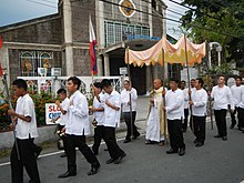
Christianity is the major religion in the town, and the majority of all Christian denomination is Catholicism where 82% of its inhabitants are baptized Roman Catholics.[12] The town has a minority of UNACAED members, Iglesia ni Cristo, Born Again sects, Jehovah's Witnesses and more.
Catholic Churches[]
- Diocesan Shrine and Parish of Our Lady of the Holy Rosary
- Our Lady of Lourdes Parish

Protestant Denominations[]
- Cardona Bethel United Methodist Church
- Cardona Church of Christ
- Cardona Christian Church
- Dae Heung Presbyterian Church
- United Christian Baptist Church
Religious Sects[]
- Different Born Again sects
- Iglesia Ni Cristo
- Jehovah's Witnesses (church defunct)
- Jesus is Lord
- Members Church of God International - Ang Dating Daan
- Unión de Adoradores Cristianos Al Espiritu Divino Inc. (UNACAED)
- Samahan ng Mananampalataya sa Espiritu ng Kadiyosan - Tres Picos
- Suprema De La Ciudad Mystica De Dios
Economy[]

| Poverty Incidence of Cardona | |
| Source: Philippine Statistics Authority[13][14][15][16][17][18] | |
Education[]
State-run Institutions[]
| Preschool Level | Kindergarten ⎯ Elementary Level | High School Level | College Level (University) |
|---|---|---|---|
| 1. Different Baranggay DayCare Centers | 1. Mariano C. San Juan Elementary School | 1. Bernardo F. San Juan National High School | 1. University of Rizal System ⎯ Cardona Campus |
| 2. Patunhay-Calahan Elementary School | 2. Cardona Senior High School | ||
| 3. Dalig Elementary School | |||
| 4. Looc Elementary School | |||
| 5. Tadlak Elementary School |
| Preschool Level | Kindergarten ⎯ Elementary Level | High School Level |
|---|---|---|
| 1. Different Baranggay DayCare Centers | 1. Tuna-Balibago Elementary School | 1. Tuna-Balibago National High School |
| 2. Boor Elementary School | 2. Catalino D. Salazar National High School |
Private Schools[]
- Castle for Achievers Learning School
- CJ Learning Center
- Lyceum Internation of the Far East (permanently closed)
- Mother Most Chaste School
- MV Montessori School
- Queen Mary Help of Christians Educational Center
- San Francisco Parish School
- Talim Island Academy Foundation
Health Institutions[]
Public Health Setvices[]
- Rural Health Unit (RHU) - Health Services are offered at the Municipal Facility, and Health Services Centers in individual Barangays. Cardona RHU is headed by Dra. Eloida Silao M.D.
Private Hospitals[]
- Queen Mary Help of Christians Hospital (Calahan)
- Carlos Medical and Maternity Hospital (Looc)
References[]
- ^ "History". 23 June 2017.
- ^ Municipality of Cardona | (DILG)
- ^ "2015 Census of Population, Report No. 3 – Population, Land Area, and Population Density" (PDF). Philippine Statistics Authority. Quezon City, Philippines. August 2016. ISSN 0117-1453. Archived (PDF) from the original on May 25, 2021. Retrieved July 16, 2021.
- ^ a b c Census of Population (2020). "Region IV-A (Calabarzon)". Total Population by Province, City, Municipality and Barangay. PSA. Retrieved 8 July 2021.
- ^ https://psa.gov.ph/sites/default/files/City%20and%20Municipal-level%20Small%20Area%20Poverty%20Estimates_%202009%2C%202012%20and%202015_0.xlsx; publication date: 10 July 2019; publisher: Philippine Statistics Authority.
- ^ "Province: Rizal". PSGC Interactive. Quezon City, Philippines: Philippine Statistics Authority. Retrieved 12 November 2016.
- ^ "Cardona: Average Temperatures and Rainfall". Meteoblue. Retrieved 11 May 2020.
- ^ Census of Population (2015). "Region IV-A (Calabarzon)". Total Population by Province, City, Municipality and Barangay. PSA. Retrieved 20 June 2016.
- ^ Census of Population and Housing (2010). "Region IV-A (Calabarzon)". Total Population by Province, City, Municipality and Barangay. NSO. Retrieved 29 June 2016.
- ^ Censuses of Population (1903–2007). "Region IV-A (Calabarzon)". Table 1. Population Enumerated in Various Censuses by Province/Highly Urbanized City: 1903 to 2007. NSO.
- ^ "Province of Rizal". Municipality Population Data. Local Water Utilities Administration Research Division. Retrieved 17 December 2016.
- ^ Philippine Statistics Authority, 2019
- ^ "Poverty incidence (PI):". Philippine Statistics Authority. Retrieved 28 December 2020.
- ^ https://psa.gov.ph/sites/default/files/NSCB_LocalPovertyPhilippines_0.pdf; publication date: 29 November 2005; publisher: Philippine Statistics Authority.
- ^ https://psa.gov.ph/sites/default/files/2003%20SAE%20of%20poverty%20%28Full%20Report%29_1.pdf; publication date: 23 March 2009; publisher: Philippine Statistics Authority.
- ^ https://psa.gov.ph/sites/default/files/2006%20and%202009%20City%20and%20Municipal%20Level%20Poverty%20Estimates_0_1.pdf; publication date: 3 August 2012; publisher: Philippine Statistics Authority.
- ^ https://psa.gov.ph/sites/default/files/2012%20Municipal%20and%20City%20Level%20Poverty%20Estima7tes%20Publication%20%281%29.pdf; publication date: 31 May 2016; publisher: Philippine Statistics Authority.
- ^ https://psa.gov.ph/sites/default/files/City%20and%20Municipal-level%20Small%20Area%20Poverty%20Estimates_%202009%2C%202012%20and%202015_0.xlsx; publication date: 10 July 2019; publisher: Philippine Statistics Authority.
External links[]
| Wikimedia Commons has media related to Cardona, Rizal. |
- Official website
- Cardona Profile at PhilAtlas.com
- Philippine Standard Geographic Code
- Philippine Census Information
- Local Governance Performance Management System
Places adjacent to Cardona, Rizal | ||||||||||||||||
|---|---|---|---|---|---|---|---|---|---|---|---|---|---|---|---|---|
| ||||||||||||||||
- Municipalities of Rizal
- Populated places on Laguna de Bay