Taytay, Rizal
Taytay | |
|---|---|
Municipality | |
| Municipality of Taytay | |
      (From top, left to right : SM City Taytay • Saint John the Baptist Church of Taytay • New Taytay Municipal Hall • Taytay Kalayaan Park • Taytay Pasig Boundary • Ortigas Avenue Extension) | |
 Seal | |
| Nickname(s): Woodworks and Garments Capital of the Philippines ' | |
| Motto(s): Best Taytay | |
| Anthem: Mabuhay Ang Taytay | |
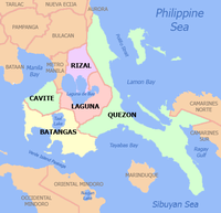
 Map of Rizal with Taytay highlighted | |
show OpenStreetMap | |
 Taytay Location within the Philippines | |
| Coordinates: 14°34′09″N 121°07′57″E / 14.56917°N 121.1325°ECoordinates: 14°34′09″N 121°07′57″E / 14.56917°N 121.1325°E | |
| Country | Philippines |
| Region | Calabarzon |
| Province | Rizal |
| District | 1st district |
| Founded | October 12, 1903[1] |
| Barangays | 5 (see Barangays) |
| Government | |
| • Type | Sangguniang Bayan |
| • Mayor | George Ricardo "Joric" R. Gacula II |
| • Vice Mayor | Michell B. Bermundo |
| • Representative | Michael John R. Duavit |
| • Municipal Council | show
Members |
| • Electorate | 153,664 voters (2019) |
| Area | |
| • Total | 38.80 km2 (14.98 sq mi) |
| Elevation | 50 m (160 ft) |
| Highest elevation | 331 m (1,086 ft) |
| Lowest elevation | 1 m (3 ft) |
| Population (2020 census) [4] | |
| • Total | 386,451 |
| • Rank | 3 out of 1,489 Municipalities |
| • Density | 10,000/km2 (26,000/sq mi) |
| • Households | 72,439 |
| Economy | |
| • Income class | 1st municipal income class |
| • Poverty incidence | 3.51% (2015)[5] |
| • Revenue | ₱723,785,579.90 (2016) |
| Service provider | |
| • Electricity | Manila Electric Company (Meralco) |
| Time zone | UTC+8 (PST) |
| ZIP code | 1920 |
| PSGC | |
| IDD : area code | +63 (0)2 |
| Climate type | tropical monsoon climate |
| Native languages | Tagalog |
| Website | www |


Taytay, officially the Municipality of Taytay (Tagalog: Bayan ng Taytay; IPA: [taɪ'taɪ]), is a 1st class municipality in the province of Rizal, Philippines. According to the 2020 census, it has a population of 386,451 people. [4] It is the 3rd most populous municipality in the country, after Rodriguez, Rizal and Cainta, Rizal.
Conurbanated with Metro Manila, it is bounded by Cainta on the north, Pasig and Taguig on the west, Antipolo in the east and Angono on the south. While economically, demographically and politically qualified, plans to convert it into a city was set aside, pending social and administrative reforms in the municipality.[6]
The National Competitiveness Council has named Taytay as the "2nd Most Competitive Municipality (1st & 2nd Class)", for year 2019 after topping the ranking last year.[7]
Taytay is one of the municipalities in the Philippines that has high financial capability with Php 775.3 million, making it the 2nd or 3rd Richest Municipality in the Philippines in 2016.[8] The elevated high capacity monorail MRT-4 is expected to terminate at the Taytay Municipal Hall with an empty lot beside it reserved for the depot.[9]
History[]
This section needs additional citations for verification. (August 2017) |
Taytay was a settlement situated along the coastline of the eastern side of Laguna de Bay that formed part of the Kingdom of Namayan, also known as the Kingdom of "Sapa", which was ruled by Lakan Tagkan. The said territory is what we know now as the district of Santa Ana, Manila.
Upon the arrival of the Franciscan missionaries on July 2, 1578, in Manila, they proceeded to evangelize the inhabitants of Namayan and organized it into a pueblo and named it Visita Santa Ana de Sapa. It comprised the communities of Meycatmon, Calatongdongan, Dongos, Dibag, Pinacauasan, Yamagtogon, Meysapan (Pasay), Malate, Dilao (Paco), Pandacan, Quiapo, Sampaloc, San Miguel, San Juan del Monte, San Felipe Neri (Mandaluyong), San Pedro Macati, and Taytay.[10]
Thence, the district of Santa Ana de Sapa became the Franciscan's central mission station.
In 1579, Taytay was formally established as a town and Church in a symbiotic relation, i.e., it presupposes that one could not have existed without the other. A church was built out of light materials and called it “Visita de Santa Ana de Sapa”. Taytay—now a larger village, a pueblo, a town—came into being, as a juridical entity as well as an actual territorial unit.
Saint John the Baptist has since been the patron of the town and the parish under the ministry of the Franciscans.
The ecclesial jurisdiction of Taytay, including the visita of Cainta, which was an annex of Taytay, were transferred to the newly arrived Jesuit missionaries in 1591. They served until 1768—for 177 years.[11]
Fray Pedro Chirino, a distinguished historian, became the first Jesuit parish priest of Taytay. He celebrated his first Holy Mass as a missionary in the swampy resettlement area on March 25, 1591, the feast of the Annunciation.[12]
Due to incessant flood, the town was relocated to a higher ground. The people followed suit after the church was rebuilt atop a hill. Taytay town was dedicated to Saint John the Baptist and christened “San Juan del Monte” [which means “Saint John of the Mountain”].[13][14] “San Juan” got the “del Monte” tag in reference to the hilly terrain of the new relocation site of the town.
Nevertheless, the townspeople continued to call their town Taytay, and Taytay it has remained to this day.[15]
This is the same location where the present St John the Baptist Parish Church still stands.[16]
Encomienda in Taytay
Adelantado Miguel Lopez de Legazpi enforced the encomienda system into the Philippine Islands since his arrival in 1565. Taytay encomienda alone had 500 natives in 1582. There were about 400 households in Taytay, while only 100 households in Antipolo in 1591 [both encomiendas had already been granted to Juan Pacheco de Maldonado]; and in that same year, Taytay encomienda also listed 600 tributantes and inhabitants of 2,400 to 3,000.[17]
The kinds of encomienda were those of the Royal Crown (encomienda de la real corona), and those of the private persons (encomienda de perticulares).[18] In 1591, the encomienda of Taytay which was included in the vast district of Santa Ana de Sapa, belonged to the Royal Crown.[19]
The lakeshore town of Taguig on the West was at the opposite side of Taytay on the East of Laguna de Bay. They were both encomiendas under the scope of Santa Ana de Sapa. They were separated by a narrow tip portion of Pasig town. Adjacent to Pasig was the area situated on the lakeshore of Barangay Santa Ana of Taytay. It was a tract of agricultural land considered as a “friar estate” which is still known today as “Lupang Arenda” which has now become a relocation and resettlement site.
“Arenda” is a lease of fixed assets or of prerogatives, such as land, or of special rights engaging in agriculture, mining, the collection of duties and taxes. “Arenda” rights are directly associated with the encomienda.
According to former Taytay Mayor Felix M. Sanvictores (1925-1931), “Lupang Arenda was donated by Don Juan Valerio Gonzales and Don Cristobal Paramdam to the Municipio in 1740. Aside from their own farmlands, Taytay farmers were also benefiting from farming in the “arenda” as well as fishing in the wide rivers flowing down the lake and in the vast flooded farmlands near the lake during the rainy season.”[20]
In February 23, 1853, a decree of the Superior Government created a district composed of the towns of Taytay, Antipolo, Bosoboso, and Cainta [from the Province of Tondo], and the towns of Morong, Baras, Tanay, Pililla, Angono, Binangonan, Cardona, and Jalajala [from the Province of La Laguna], with Morong as its capital town.[21] It was later called Distrito Politico-Militar de Morong.
The coming of Americans
Taytay suffered heavy casualties during the Philippine–American War in 1899, with the church almost burned down and most of the town razed to the ground.[16]
On June 11, 1901, Taytay became part of the newly created Province of Rizal by virtue of an Act No. 137 enacted by the First Philippine Commission. In 1903, Taytay was merged with the neighboring towns of Cainta and Angono by virtue of Act No. 942. That did not last long as Angono was separated to be merged with Binangonan later that year and Cainta became an independent town again in 1914.[22]
During the Second World War, Taytay was occupied by Japanese forces in 1942. Local soldiers of the pre-war 42nd Infantry Division of the Philippine Commonwealth Army and 4th Constabulary Regiment of the Philippine Constabulary liberated and entered Taytay in 1945 to help the recognized guerrilla fighter units to defeat and attack the Japanese Imperial Army. On November 7, 1975, by virtue of Presidential Decree No. 824, which created the Metro Manila Area, Taytay was among the towns that remained within the Province of Rizal.[citation needed]
Campaign for Cityhood[]
Taytay has its growth of population and income, which qualifies for cityhood. Like its neighbor Cainta, it did not fully qualified to be a city due to boundary disputes. Its cityhood bid was supported by the League of Cities of the Philippines[23] and then-governor of Rizal, Casimiro Ynares III.[24] It was currently set aside for the meantime, citing that there are priorities that needed to be attended to before cityhood.[25]
National Competitiveness[]
The National Competitiveness Council has named Taytay as the "2nd Most Competitive Municipality (1st & 2nd Class) since 2016 until 2017",[26][27] up from 10th place in 2014[28] and 3rd place in 2015.[29] In The Year 2018, The Municipality of Taytay jumped from "2nd Most Competitive Municipality" to "1st Most Competitive Municipality (1st & 2nd Class)
Geography[]
It is situated in the province's western portion, bounded by the grids 14° 34’ 24" north latitude and 121° 07’ 48" east longitude. It shares boundaries with Cainta in the Northwest, Antipolo in the North-north-east, Angono in the East-southeast and Taguig in the Southwest. The municipality is sited to East of Pasig and to the North of Laguna Lake. It has an area of 38.80 km2 (14.98 sq mi) representing 3.3% of Rizal Province's land area.
The shape of Taytay is rectangular – trapezoidal with gently hilly rolling terrain on its eastern side while relatively flat on its south-western side, including the poblacion. The municipality's highest elevation ranges from 200 to 255 meters which is situated along the inner north-eastern hills of Barangay Dolores, alongside the Antipolo Boundary. Its lowest points are from 5 to 20 meters along the southern portion of Barangay San Juan and Muzon towards Laguna Lake.
From Laguna de Bay, Pasig River runs between Taguig, and Taytay, Rizal, before entering Pasig.
The Manggahan Floodway lessens flood conditions in Metro Manila by carrying flood waters to Laguna de Bay, but contributes to flooding of the coastal areas of Taguig, Taytay, and other towns in Laguna and Rizal along the lake.
The municipality is principally drained by south-west trending rivers such as Taytay River, Panghulo River, and Napindan Channel, all of which empties into Laguna Lake. Taytay River flows across Barangays Dolores and San Isidro and joins Antipolo River (present course of Manggahan Floodway) as it passes through the southern end of Barangays Santa Ana and San Juan. Panghulo River snakes its way from upper Taytay across Barangay San Juan towards the southern portion of Barangay Muzon. Napindan Channel crosses the southern boundaries of Barangay Santa Ana and San Juan as it empties into Laguna Lake. Bangiad Creek, found at the south-eastern limits of the municipality, flows south-west ward across Barangay Muzon, extending toward Laguna Lake.
Location[]
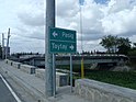
Taytay is 20 kilometres (12 mi) away from Manila. It is accessible from various points from Metro Manila through the Ortigas Avenue Extension, Manila East Road, Felix Avenue (formerly Imelda Avenue), A. Bonifacio Avenue, Manggahan Floodway, and Sumulong Highway.
Barangays[]


Taytay still has only five barangays since the late period of the Spanish era. This political subdivision remains the same even though Taytay consistently ranks among the top municipalities throughout the country in terms of economic development and status and population density. Taytay conspicuously has the fewest barangays throughout the country. Today there is a clamor from its citizens for the creation of more barangays for better coordination and management of its huge terrain and growing population.
[30] San Juan is the largest and most populous barangay and is the center of the municipality and its local industries.
| Barangay | Population (2015) [31] | Barangay Captain | Land Area (ha.) |
|---|---|---|---|
| Dolores (Poblacion) | 61,115 |
Allan Martine "Barbie" S. De Leon | 1237
|
| Barangay Muzon | 26,523 |
Frank Luster "Buboy" Santos | 341
|
| San Isidro | 36,780 |
Vivian Reyes-Yupangco | 442
|
| San Juan | 103,343 |
Roseller "Rasel" Z. Valera | 1,490
|
| Santa Ana | 91,343 |
Michael "Tisoy" Amagsila- Cruz | 800
|
Climate[]
| hideClimate data for Taytay, Rizal | |||||||||||||
|---|---|---|---|---|---|---|---|---|---|---|---|---|---|
| Month | Jan | Feb | Mar | Apr | May | Jun | Jul | Aug | Sep | Oct | Nov | Dec | Year |
| Average high °C (°F) | 29 (84) |
30 (86) |
32 (90) |
34 (93) |
33 (91) |
31 (88) |
30 (86) |
29 (84) |
29 (84) |
30 (86) |
30 (86) |
29 (84) |
31 (87) |
| Average low °C (°F) | 20 (68) |
20 (68) |
21 (70) |
23 (73) |
24 (75) |
25 (77) |
24 (75) |
24 (75) |
24 (75) |
23 (73) |
22 (72) |
21 (70) |
23 (73) |
| Average precipitation mm (inches) | 7 (0.3) |
7 (0.3) |
9 (0.4) |
21 (0.8) |
101 (4.0) |
152 (6.0) |
188 (7.4) |
170 (6.7) |
159 (6.3) |
115 (4.5) |
47 (1.9) |
29 (1.1) |
1,005 (39.7) |
| Average rainy days | 3.3 | 3.5 | 4.8 | 8.1 | 18.9 | 23.5 | 26.4 | 25.5 | 24.5 | 19.6 | 10.4 | 6.4 | 174.9 |
| Source: Meteoblue[32] | |||||||||||||
Demographics[]
| Year | Pop. | ±% p.a. |
|---|---|---|
| 1903 | 6,067 | — |
| 1918 | 7,429 | +1.36% |
| 1939 | 10,891 | +1.84% |
| 1948 | 14,144 | +2.95% |
| 1960 | 21,747 | +3.65% |
| 1970 | 46,717 | +7.94% |
| 1975 | 58,274 | +4.53% |
| 1980 | 75,328 | +5.27% |
| 1990 | 112,403 | +4.08% |
| 1995 | 144,748 | +4.85% |
| 2000 | 198,183 | +6.97% |
| 2007 | 262,485 | +3.95% |
| 2010 | 288,956 | +3.56% |
| 2015 | 319,104 | +1.91% |
| 2020 | 386,451 | +3.84% |
| Source: Philippine Statistics Authority [31] [33] [34][35] | ||
In the 2020 census, the population of Taytay, Rizal, was 386,451 people, [4] with a density of 10,000 inhabitants per square kilometre or 26,000 inhabitants per square mile.
Economy[]
| Poverty Incidence of Taytay | |
| Source: Philippine Statistics Authority[36][37][38][39][40][41] | |
Local government[]

Elected officials (As of May 2019 Elections):
- Mayor: George Ricardo R. Gacula II
- Vice Mayor: Michell B. Bermundo
- Councilors:
- Sophia Priscilla L. Cabral
- Ma. Jeca B. Villanueva
- Patrick Alcantara
- Joanne Marie P. Calderon
- Ceferino R. Resurreccion, Jr.
- Kyle Georic Y. Gacula
- Ma. Elaine Leonardo
- Philip Jeison J. Cruz
- ABC President: FRank Luster Santos
- SK President: Roda May Dino

List of local chief executives[]
| Name | Title | Served (From) | Until |
|---|---|---|---|
| Celdonio Javier | Mayor | 1901 | 1902 |
| Lorenzo Lacanienta | Mayor | 1902 | 1903 |
| Adaucto Ocampo | Mayor | 1903 | 1904 |
| Exequiel Ampil | Mayor | 1904 | 1907 |
| Honesto Gonzaga | Mayor | 1908 | 1911 |
| Jorge Basig | Mayor | 1912 | 1913 |
| Gonzalo V. Naval, Sr. | Mayor | 1913 | 1918 |
| Ciriaco Valle | Mayor | 1918 | 1921 |
| Aquilino Velasquez | Mayor | 1922 | 1925 |
| Felix M. Sanvictores | Mayor | 1925 | 1931 |
| Aquilino Velasquez | Mayor | 1931 | 1934 |
| Eladio T. Alcantara | Mayor | 1934 | 1937 |
| Enrique L. Reyes | Mayor | 1938 | 1944 |
| Delfin R. Del Rosario | Acting Mayor | 1944 | 1945 |
| Manuel I. Santos | OIC Mayor | 1946 | 1947 |
| Emiliano I. Cruz | Mayor | 1948 | 1951 |
| Manuel I. Santos | Mayor | 1952 | 1963 |
| Antonio C. Esguerra | Mayor | 1964 | 1971 |
| Benjamin B. Esguerra | Mayor | 1972 | 1979 |
| Manuel I. Santos | Mayor | 1980 | 1981 |
| Ricardo J. Rufino | Mayor | 1981 | 1986 |
| Romeo C. De leon | Acting Mayor | 1986 | 1987 |
| Isidro T. Sanvictores | OIC Mayor | 1988 | |
| Godofredo C. Valera | Mayor | 1988 | 1998 |
| June Valera Zapanta | Mayor | 1998 | 2004 |
| Joric Gacula | Mayor | 2004 | 2013 |
| Janet De Leon-Mercado | Mayor | 2013 | 2016 |
| Joric Gacula | Mayor | 2016 | Present |
Seal[]
The Municipal seal is composed of a gold-colored single circular arc, encrypted with the word "BAYAN NG TAYTAY" at the upper part and "LALAWIGAN NG RIZAL" at the lower part.
The emblem at the center represents the town, its colors came from the Philippine Flag. The left side resembles two-crossed hammers and grills, represents the Taytay's industrious workers while right side resembles a sewing machine and a scissor represents the People of Taytay which were marked in the field of Dress-making. Conspicuously, this also represents the HaMaKa (Hamba, Makina at Kabuhayan) that Taytay is celebrating annually. The five stars at the most upper part, represents the five barangays that compose the municipality. Finally, the scroll at the bottom part encrypted with "Republika ng Pilipinas" basically pertains to the Philippine Republic.
Economy[]
Garment industry[]
Garment industry is the main economic driver of the town known for its high quality ready-to-wear (RTW) clothing. The town's garment industry and its related downstream cottage industries provide livelihood and employment opportunities to people on its villages where subcontracting among household families is a cottage industry. It has also spawned small entrepreural brick-and-mortar stores and online sellers among its residents. The upstream industries created is the mushrooming of textile markets, sewing machine making, and cargo and delivery.
Taytay town is now the Philippines' production hub of cheaper ready-to-wear clothes. It enabled the country to resurrect its garment industry back after decades of hiatus due to competition from countries such as Bangladesh, Cambodia, Vietnam and to a certain extent China. It is now displacing imported clothings due to its highly competitive pricing, wide array designs and quality.
The industry earned it the monicker as the "Garments Capital of the Philippines."
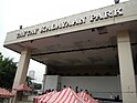
Today, various shops cluster in Kalayaan park every Friday or in Club Manila East Open Space every Saturday to take the advantage of low-cost ready-made clothings.[42]
As of 2017, there are around 10 garments center operating in Club Manila East Compound. Each garment center has hundreds to thousands of stalls selling different clothes by family owned garment factories. Of these ten, the biggest are Taytay Municipal Tiangge, Bagpi Garment Center, Igpai Garment Center, MASUERTE 4JC Tiangge and Freedom bazaar. Each center has varying schedule of opening and closing but almost all are open on main market days of Monday and Thursday evenings.[43]
Wood-based industry[]
The smaller wood working industry is another contributor to its economy.
Woodworks continue to be a valuable source of income among the residents of this town. Several carving shops continue to survive despite the threats of cheaper imported products.
Among woodworks produced in the town are doors, furnitures, and other wood-based products.

Several multinational companies have also made their presence here, which include SM Prime Holdings, Puregold Price Club Inc., Wilcon Builders, Megaworld Constructions and several more.
Taytay's local income surged to Php 770 million during the first quarter in 2016, making it the second richest municipality in the province after Cainta.[44] The economy is in transitory period from agricultural to a more pronounced commercial and industrial activities.
Commerce and industry[]
Commerce and industry is a very active economic sector in the municipality. This sector contributes a substantial income to the municipal coffers.
As of late 2009s, commercial activity dominated the economic landscape with 75% of the total number of economic establishments registered with the Business Permits and Licensing Division of the municipal government. There are more than 7000 commercial and industrial firms operating in the municipality.
SM City Taytay is a shopping mall owned and constructed by SM Prime Holdings. It is the first SM Supermall in the province in Rizal. The mall is located in Manila East Road Taytay, Rizal. The mall consists of two buildings interconnected with a bridge featuring anchors like the SM Hypermarket, SM Department Store, SM Cinemas, SM Foodcourt, Watsons, SM Appliance Center, Ace Hardware and various shops and restaurants. In 2014, SM Prime announced the expansion of the mall, with a four-storey mix commercial and office building set to rise in the newly acquired lot adjacent to the mall.[45] Robinsons Companies are also conducting studies for the possibility of constructing another mall in province. Coca-Cola Inc., San Miguel Breweries, Megaworld, Santa Lucia Realty, CityMall, Xentro Mall and Ayala Land have either planned or expanded its business portfolio in Taytay citing reasons of economic viability, strong internal market and accessibility. In 2012, the town was ranked second after Cainta in the Philippines for the highest income.[46]
Tourism and leisure[]
Club Manila East (CME) is another getaway destinations in the heart of the municipality of Taytay. The resort-hotel has a 9,100 sqm "Funtasy Lagoon" pool which is a scaled-down model of Laguna de Bay. The surrounding day-tour cabanas, good for up to 20 persons and complete with shower and bath are named after the surrounding towns of Laguna de Bay. CME, with Philippine Surfing Academy (PSA), also conducts surfing lessons in its two wavepools, the "Beachwaves" and the "Oceanwaves". The Oceanwaves is the biggest of its kind in the country with powerful waves rising up to 1.5 meters high. And through its "CME FLY", a 6-floor-high, 360-meter-long zipline, CME takes its guests to a high adrenaline level. The latest addition to the facilities of CME is the Beach Volleyball court. To date, CME has 70 overnight villas, and 4 big-room dormitories. It has various seminar and function facilities to accommodate 50 to 1,000 people. And to serve the food needs of its clients, the Doña Nelia Restaurant serves a wide range of Filipino and Continental dishes at very affordable prices.[47]
Real estate industry[]
In 2014, MySpace Properties, A Megawide Construction Corporation Subsidiary, has unveiled its newest mix-use commercial and residential complex along Ortigas Avenue in Barangay San Isidro, dubbed as The Hive Malls + Residences. The project sits beside Baltao compound and has a frontage of more than one hundred meters. It will host several commercial establishments and residential condominiums, providing a one-stop shop for Taytayenos who need not travel more to avail of some services and commercial goods. The project kicked off this October and is expected to be completed in the next one to two years.[48]
IT industry[]
Taytay has a budding business processing outsourcing industry as it hosts some BPO locators. In 2016, Taytay was named as one of the 10 Next Wave Cities in the Philippines[49] making it the next hub for the information technology and business process management (IT-BPM) sector. The location of Taytay was identified based on the 2015 assessment guided by the NWC scorecard, which includes the following criteria: talent, infrastructure, cost, and business environment.
Robinsons Companies are also conducting studies for the possibility of constructing another mall in the province. Coca-Cola Inc., San Miguel Breweries, Megaworld, Santa Lucia Realty, CityMall and Ayala Land have either planned or expanded its business portfolio in Taytay, citing reasons of economic viability, strong internal market and accessibility.[50]
Infrastructure[]
Waste management[]
Taytay has a current total fleet of only ten dump trucks that regularly collect the garbage generated by its five barangays. Their capabilities can haul the average generated solid waste of 50–60 tons per day based on population. These are dumped three kilometers away in a valley area near the boundary with Antipolo north-east of the town center and adjacent to Rosario Memorial Park.
Transportation[]
Taytay has an existing road network with a total length of 139.666 km. The two main roads cutting through Taytay and serving as the main access from Metro Manila are Rizal Avenue which leads to the Poblacion and the Central Business district of the town and the Manila East Road connecting from Ortigas Avenue Extension which passes north and north-east of the town center. The roads meet at a junction just off the location of the New Taytay Public Market towards the adjacent town of Angono on its eastern boundary.
Before World War II, Taytay was also served by a railway system. Known as the Antipolo Line, this railroad line passed through Santa Mesa, Mandaluyong, Pasig, and Cainta, going all the way up to Antipolo near the Hinulugang Taktak Falls.[51] Apart from a street named "Daangbakal" in Antipolo, no traces of this line presently survive especially in the Cainta and Taytay areas where the railway tracks used to be as roads have been paved over them.
Today, the town's transport needs are served by tricycles, jeepneys, taxis, buses, and UV Express services, many of which serve to link the town to Metro Manila where many of the town's citizens work and study.
A proposed rapid transit line, Manila Light Rail Transit System Line 4, to be built in Metro Manila and Rizal Province will link Taytay to Ortigas Center business center. When completed, it is expected to significantly reduce the volume of vehicular traffic along Ortigas Avenue and improve connectivity in the eastern parts of the metropolis, including the nearby municipalities in southern Rizal.
One exit point of the under construction Southeast Metro Manila Expressway will help decongest the existing roadways across Metro Manila, such as EDSA and Circumferential Road 5. SEMME is also known as Skyway Stage 4.
Power[]
The provision of efficient power services is the linchpin of productivity Any area that envisions itself to modernize, to be more productive, and its product competitive needs to have ample power supply to engine its growth and development.
It has been recorded that Taytay is the third largest user of power among the towns of Rizal, which all have been energized and served the Meralco. This makes Taytay a town with sufficient power for domestic use. Added to this is the presence of a substation of the National Power Corporation in Barangay Dolores.
Communications[]
Communication is another major and key infrastructure component. Its ample availability in an area is one of the essential requisites for economic progress and social integration.
Currently, majority of the communication needs of the people of Taytay are being served by the Philippine Long Distance Telephone Company (PLDT) with some availing of cellular phone and paging services. The number of telephones of the town is far beyond the minimum of one telephone line per 1000 residential population and also a single telephone line per 1500 population in industrial areas.
The town operates a telegraph services unit which issues an average of 116 transmissions and 5,483 telegrams of all kinds per month.
Taytay can be reached by all radio and television stations, printed communications such as newspapers and magazines are distributed from Metro Manila.
Medical and health care[]
The provision of primary health care is being undertaken by the Municipal Health Office which provides medical services to the Municipals five barangays. Taytay has seven health units with a total of 40 Barangay Health Centers. These are commonly staffed of doctors, nurses, dentists, midwives, etc. Only Taytay Emergency Hospital which is based at the Office of Municipal Health Officer at the Municipal Hall has daily schedule of medical services from Mondays through Sundays, 24 hrs a day. The other units are on scheduled basis.
The services offered by these hospitals and clinics to the municipal and provincial residents include out-patient treatment, child delivery, EENT treatment, surgery, internal medicine, pediatric, obstetrics and gynecological treatment and diagnosis of social diseases.
Some of the hospitals in Taytay are Taytay Emergency Hospital and Manila East Medical Center(MEMC) and the new Taytay Doctors Hospital.
Education[]
This section reads like a directory. (September 2018) |
Public Secondary Schools[]
- Antonio C. Esguerra Memorial National High School
- Benjamin B. Esguerra Memorial National High School
- Casimiro A. Ynares Sr. Memorial National High School
- Manuel I. Santos Memorial National High School
- Muzon National High School
- Simona National High School
- Taytay National High School
Private secondary[]
- Affordable Private Education Center Schools - Taytay Branch
- Angel of Wisdom Academy
- Divine Child Jesus School (Catholic, Educational)
- GB Knowledge Center
- Golden Faith Academy (Protestant)
- Golden Faith Academy with Special Education Center
- Jewels of Heaven Learning Center (Protestant)
- Lord's Jewels Christian School, Inc. (formerly Little Jewels Christian School) (Protestant)
- Master's Vineyard Academy (Protestant, Pre-school to High school)
- Raises Montessori Academe
- Sacred Heart of Jesus Academe
- Saint Michael the Archangel School of Rizal (Science school)
- Shekinah Christian School (Protestant)
- Silver Gold Integrated School (Protestant)
- St. John The Baptist Parochial School (Parish)
- Star of Hope Christian School (Protestant)
- Taytay United Methodist Christian School, Inc. (Protestant)
- Web tech International Academy
Tertiary education[]
- University of Rizal System (URS) - Taytay Campus
- Siena College of Taytay
- San Beda University - Rizal Campus
- Daehan College of Business and Technology
- Trent Information First (TIF) Technical Career Institute, Inc. - Taytay campus
- National College of Business and Arts (NCBA) - Taytay, Rizal campus
- Juan Sumulong Memorial Junior College
- Asian Institute of Computer Studies (AICS) - Taytay Campus
- Baptist Bible Seminary and Institute (Seminary)
- Asia-Pacific Nazarene Theological Seminary (Seminary)
Notable people[]
- Alice Dixson - Actress, Philippines' representative for Miss International in 1986
- Toni Gonzaga-Soriano - Actress, Singer, TV Host, ("The Ultimate Multimedia Star")
- Alex Gonzaga - TV Host, Vlogger, Actress, Comedian, Book Author
- Rachel Anne Daquis - Volleyball Athlete
- Xyriel Manabat - Child/Teen Actress
- Meg Imperial - Model, Actress
- Andrea Brillantes - Child/Teen Actress, Dancer (BFF 5 of ASAP)
- Jon Lucas - Teen Actor, Dancer, Rapper (former member of Hashtags of It's Showtime!)
- Oliver Barbosa - Chess Grand Master
- Rez Cortez - Res Septimo Cortez (born January 4, 1956), better known as Rez Cortez, is a Filipino Veteran actor and assistant director.
References[]
- ^ [1][dead link]
- ^ Municipality of Taytay | (DILG)
- ^ "2015 Census of Population, Report No. 3 – Population, Land Area, and Population Density" (PDF). Philippine Statistics Authority. Quezon City, Philippines. August 2016. ISSN 0117-1453. Archived (PDF) from the original on May 25, 2021. Retrieved July 16, 2021.
- ^ Jump up to: a b c Census of Population (2020). "Region IV-A (Calabarzon)". Total Population by Province, City, Municipality and Barangay. PSA. Retrieved 8 July 2021.
- ^ https://psa.gov.ph/sites/default/files/City%20and%20Municipal-level%20Small%20Area%20Poverty%20Estimates_%202009%2C%202012%20and%202015_0.xlsx; publication date: 10 July 2019; publisher: Philippine Statistics Authority.
- ^ [2]
- ^ Top 10 Richest Municipality: [3], 2019
- ^ Top 10 Richest Municipality: [4], 2015
- ^ https://www.meti.go.jp/meti_lib/report/2015fy/000292.pdf
- ^ de Huerta, Felix (1865). Estado Geografico, Tofografico, Estodestico, Historico Religioso, de la Santa y Apostolica Provincia de San Gregorio Magno, de religiosos menores de scalzos de la regular y más estrecha observancia de N.S.P.S. Francisco, en las islas Filipinas. Imprenta de M. Sánchez y Cía, Manila. pp. 50, 53.
- ^ Fernandez, Jose "Ding" A. (2013). Lakbay-Pananampalataya--Parokya ni San Juan Bautista, Taytay. p. 15.
- ^ Fernandez, Jose Ding. Lakbay-Pananampalataya -- Parokya ni San Juan Bautista, Taytay. 15 Sept 2013. p-16.
- ^ Chirino del P. Pedro. Relacion de las Islas Filipinas y de lo que en ellas han trabajado los padres de la Compania de Jesus, 1557-1635. Roma, 1604; 2 Edicion, Manila, 1890; Capitulo XX, p 69.
- ^ de la Costa, SJ., Horacio (1961). The Jesuits in the Philippines 1581-1768.Cambridge, Massachusetts, Harvard University Press. p. 138.
- ^ de la Costa, SJ., Horacio (1961). The Jesuits in the Philippines 1581-1768.Cambridge, Massachusetts, Harvard University Press. pp. p. 138.
- ^ Jump up to: a b Fernandez, Jose (2013). Lakbay-Pananampalataya. Taytay, Rizal: St John the Baptist Parish.
- ^ Feernandez, Jose Ding (25 March 2017). Juan de Plasencia, OFM -- Tatay ng Taytay ni Juan. p. 24.
- ^ Relacion de las Encomiendas, existentes en Filipinas. Retana, Archivo del Bibliófilo Filipino, Vol. IV.
- ^ Jose "Ding" Fernandez. Juan de Plasencia, OFM: Tatay ng Taytay ni Juan. p.23-24 (Part 2); ACADEMIA.EDU.
- ^ Feernandez, Jose Ding (25 March 2017). Juan de Plasencia, OFM -- Tatay ng Taytay ni Juan. p. 26.
- ^ Huerta. p.101-102.
- ^ Tanay Tercenary Souvenir: 1640-1940 & The Towns of Rizal Province. Catolos, Bendana & Santos. 1940.
- ^ "Mayors endorse cityhood of 21 towns". League of Cities of the Philippines. March 16, 2011. Archived from the original on May 18, 2014. Retrieved August 30, 2017.
- ^ "Cityhood eyed for Taytay, Cainta towns". Philippine Daily Inquirer. January 5, 2010. Archived from the original on January 9, 2010. Retrieved August 30, 2017.
- ^ Belen, Leonardo (April 5, 2014). "Lady mayor steers Taytay (Rizal) to dynamic progress". Towns & Cities.
- ^ The Cities and Municipalities Competitiveness Index 2016: [5], 2016
- ^ The Cities and Municipalities Competitiveness Index 2017: [6], 2017
- ^ The Cities and Municipalities Competitiveness Index:"Archived copy". Archived from the original on 2014-10-27. Retrieved 2016-04-30.CS1 maint: archived copy as title (link),2014
- ^ The Cities and Municipalities Competitiveness Index 2015:[7] Archived 2014-08-21 at the Wayback Machine, 2015
- ^ Fernandez, Jose Ding (18 May 2018). "Payag ka bang 5 Barangay lang ang Taytay?". Taytay ni Juan.
- ^ Jump up to: a b Census of Population (2015). "Region IV-A (Calabarzon)". Total Population by Province, City, Municipality and Barangay. PSA. Retrieved 20 June 2016.
- ^ "Taytay: Average Temperatures and Rainfall". Meteoblue. Retrieved 11 May 2020.
- ^ Census of Population and Housing (2010). "Region IV-A (Calabarzon)". Total Population by Province, City, Municipality and Barangay. NSO. Retrieved 29 June 2016.
- ^ Censuses of Population (1903–2007). "Region IV-A (Calabarzon)". Table 1. Population Enumerated in Various Censuses by Province/Highly Urbanized City: 1903 to 2007. NSO.
- ^ "Province of Rizal". Municipality Population Data. Local Water Utilities Administration Research Division. Retrieved 17 December 2016.
- ^ "Poverty incidence (PI):". Philippine Statistics Authority. Retrieved 28 December 2020.
- ^ https://psa.gov.ph/sites/default/files/NSCB_LocalPovertyPhilippines_0.pdf; publication date: 29 November 2005; publisher: Philippine Statistics Authority.
- ^ https://psa.gov.ph/sites/default/files/2003%20SAE%20of%20poverty%20%28Full%20Report%29_1.pdf; publication date: 23 March 2009; publisher: Philippine Statistics Authority.
- ^ https://psa.gov.ph/sites/default/files/2006%20and%202009%20City%20and%20Municipal%20Level%20Poverty%20Estimates_0_1.pdf; publication date: 3 August 2012; publisher: Philippine Statistics Authority.
- ^ https://psa.gov.ph/sites/default/files/2012%20Municipal%20and%20City%20Level%20Poverty%20Estima7tes%20Publication%20%281%29.pdf; publication date: 31 May 2016; publisher: Philippine Statistics Authority.
- ^ https://psa.gov.ph/sites/default/files/City%20and%20Municipal-level%20Small%20Area%20Poverty%20Estimates_%202009%2C%202012%20and%202015_0.xlsx; publication date: 10 July 2019; publisher: Philippine Statistics Authority.
- ^ "Taytayrizal.net". Taytayrizal.net. Archived from the original on 2014-02-19. Retrieved 2014-01-24.
- ^ "The Ultimate Guide to Tiangge Shopping in Taytay, Rizal (2019 Edition)". Archived from the original on 2017-09-19.
- ^ "L G P M S". Blgs.gov.ph. Retrieved 2014-01-24.
- ^ [8]
- ^ "Top 10 Philippine Cities: Per Capita Income, Tax Revenues". PinoyMoneyTalk.com. 16 July 2012. Retrieved 2019-10-26.
- ^ "Home - Best Guaranteed Rate". Club Manila East. 2019-06-17. Retrieved 2019-10-26.
- ^ "Archived copy". Archived from the original on 2014-12-25. Retrieved 2014-11-14.CS1 maint: archived copy as title (link)
- ^ Posted at Mar 30 2016 04:43 PM (2016-03-30). "10 'next wave' cities in PH named". ABS-CBN News. Retrieved 2019-10-26.
- ^ "Commerce and Industry". Archived from the original on 2017-03-07.
- ^ "Antipolo Extension". Laguna Railways. Railways and Industrial Heritage Society of the Phils., Inc.
External links[]
| Wikimedia Commons has media related to Taytay, Rizal. |
- Taytay Profile at PhilAtlas.com
- Philippine Standard Geographic Code
- Philippine Census Information
- Local Governance Performance Management System
| show Places adjacent to Taytay, Rizal |
|---|
| show Articles Related to Taytay, Rizal |
|---|
| Authority control |
|
|---|
- Taytay, Rizal
- Municipalities of Rizal
- Populated places on Laguna de Bay
- Populated places on the Pasig River