Mabini, Batangas
Mabini | |
|---|---|
| Municipality of Mabini | |
 | |
 Seal | |
| Nickname(s): Diving Capital of the Philippines | |
 Map of Batangas with Mabini highlighted | |
OpenStreetMap  | |
 Mabini Location within the Philippines | |
| Coordinates: 13°43′N 120°54′E / 13.72°N 120.9°ECoordinates: 13°43′N 120°54′E / 13.72°N 120.9°E | |
| Country | Philippines |
| Region | Calabarzon |
| Province | Batangas |
| District | 2nd district |
| Founded | January 1, 1918 |
| Named for | Apolinario Mabini |
| Barangays | 34 (see Barangays) |
| Government | |
| • Type | Sangguniang Bayan |
| • Mayor | Noel B. Luistro |
| • Vice Mayor | Pablo M. Villanueva Jr. |
| • Representative | Raneo E. Abu |
| • Municipal Council | Members |
| • Electorate | 31,057 voters (2019) |
| Area | |
| • Total | 44.47 km2 (17.17 sq mi) |
| Elevation | 53 m (174 ft) |
| Highest elevation | 490 m (1,610 ft) |
| Lowest elevation | 0 m (0 ft) |
| Population (2020 census) [3] | |
| • Total | 50,858 |
| • Density | 1,100/km2 (3,000/sq mi) |
| • Households | 9,757 |
| Economy | |
| • Income class | 1st municipal income class |
| • Poverty incidence | 7.28% (2015)[4] |
| • Revenue | ₱250,227,330.22 (2020) |
| • Assets | ₱726,172,771.21 (2020) |
| • Expenditure | ₱214,114,167.63 (2020) |
| • Liabilities | ₱77,336,484.92 (2020) |
| Service provider | |
| • Electricity | Batangas 2 Electric Cooperative (BATELEC 2) |
| Time zone | UTC+8 (PST) |
| ZIP code | 4202 |
| PSGC | |
| IDD : area code | +63 (0)43 |
| Native languages | Tagalog |
| Website | www |

Mabini, officially the Municipality of Mabini (Tagalog: Bayan ng Mabini), is a 1st class municipality in the province of Batangas, Philippines. According to the 2020 census, it has a population of 50,858 people. [3]
Mabini is known for its diving and snorkeling sites. It is named after Apolinario Mabini, a Filipino revolutionary hero.[5]
History[]
This section contains weasel words: vague phrasing that often accompanies biased or unverifiable information. (November 2016) |

Legend states that the first Malay settlers to inhabit the vast fertile land bordering the two bodies of water now known as the Batangas Bay and the Balayan Bay, first found anchor along the shores of the land protruding down Southwest ward known geographically as the Calumpan Peninsula.
These Malay settlers found the land fertile and agriculturally appropriate and the sea rich in marine resources. They established their settlement in this once vast unknown land. As more Malay settlers arrived from distant lands, more settlements were founded until even the upland regions of the peninsula were settled. The inhabitants had their own form of village government. They were ruled by a headman, a datu, or a sultan, in case of big encampments. Malay civilization began to take roots. Rapid increase of population brought about the settlements of all the neighboring regions, that it did not take long before several nearby regions were inhabited later on to comprise the whole province of Kumintang, better known later as Batangas.
During the Spanish colonial rule, the Calumpan Peninsula was made a part of the pueblo of Bauan, in the province of Kumintang. The same peninsula territory of Bauan was subdivided into barrios: Mainaga, Pulong-Niogan, Pulong-Balibaguhan, Anilao, Solo, Pulong-Anahao, Bagalangit, Nag-Iba, Malimatoc, Saguing and Talaga. For more than three hundred years, while the Archipelago was under Spanish domination, the peninsula remained a part of the “pueblo” of Bauan even until the early part of the American occupation. The people of this peninsula, like other people of other regions, suffered untold hardships under the Spanish rule. The yoke of the Spanish tyranny was thrown off after the gallant uprising of 1896. The revolution emancipated the people from the tyrants of Spain. Foremost of the heroic young men was Don Francisco Castillo, known as Apian Kiko, who led the fight for freedom in this peninsula.
After efforts had been exerted by the proponents of establishing a new municipality independent of the town of Bauan, eleven (11) barrios of the Calumpan Peninsula and the whole of the Maricaban Island was declared an independent municipality, with the name Mabini, derived from the Philippine hero Apolinario Mabini. The new-born municipality of Mabini was inaugurated on January 1, 1918, with Captain Francisco Castillo, known as the founder of the town, as the first appointive Municipal President.[5]
Geography[]
According to the Philippine Statistics Authority, the municipality has a land area of 44.47 square kilometres (17.17 sq mi) [6] constituting 1.43% of the 3,119.75-square-kilometre (1,204.54 sq mi) total area of Batangas.
Barangays[]
Mabini is politically subdivided into 34 barangays.[7] Barangay San Juan was formerly the sitios of Nag-ilong and Lugay in the barrio of Mainaga, constituted into a separate and independent barangay through Republic Act No. 212, approved June 1, 1948.[8]
| PSGC | Barangay | Population | ±% p.a. | |||
|---|---|---|---|---|---|---|
| 2020 [3] | 2010 [9] | |||||
| 041016001 | Anilao Proper | 1.3% | 650 | 611 | 0.64% | |
| 041016002 | Anilao East | 3.2% | 1,626 | 1,566 | 0.39% | |
| 041016003 | Bagalangit | 4.8% | 2,458 | 2,613 | −0.63% | |
| 041016004 | Bulacan | 2.7% | 1,351 | 1,281 | 0.55% | |
| 041016005 | Calamias | 2.2% | 1,123 | 1,023 | 0.96% | |
| 041016006 | Estrella | 1.4% | 716 | 631 | 1.31% | |
| 041016007 | Gasang | 4.8% | 2,455 | 2,349 | 0.45% | |
| 041016008 | Laurel | 2.4% | 1,220 | 1,183 | 0.32% | |
| 041016009 | Ligaya | 1.7% | 889 | 1,205 | −3.08% | |
| 041016010 | Mainaga | 3.8% | 1,951 | 1,735 | 1.21% | |
| 041016011 | Mainit | 2.1% | 1,076 | 1,050 | 0.25% | |
| 041016012 | Majuben | 1.4% | 725 | 640 | 1.29% | |
| 041016014 | Malimatoc I | 1.9% | 955 | 938 | 0.18% | |
| 041016015 | Malimatoc II | 2.0% | 999 | 1,141 | −1.36% | |
| 041016016 | Nag‑Iba | 1.7% | 886 | 904 | −0.21% | |
| 041016017 | Pilahan | 1.5% | 765 | 643 | 1.80% | |
| 041016018 | Poblacion | 3.8% | 1,911 | 1,472 | 2.72% | |
| 041016019 | Pulang Lupa | 1.9% | 969 | 1,220 | −2.34% | |
| 041016020 | Pulong Anahao | 2.4% | 1,227 | 1,200 | 0.23% | |
| 041016021 | Pulong Balibaguhan | 1.8% | 940 | 887 | 0.60% | |
| 041016022 | Pulong Niogan | 3.5% | 1,755 | 1,268 | 3.40% | |
| 041016023 | Saguing | 2.6% | 1,302 | 1,313 | −0.09% | |
| 041016024 | Sampaguita | 3.2% | 1,621 | 1,550 | 0.46% | |
| 041016025 | San Francisco | 4.0% | 2,052 | 1,762 | 1.58% | |
| 041016026 | San Jose | 1.7% | 876 | 865 | 0.13% | |
| 041016027 | San Juan | 4.2% | 2,124 | 1,975 | 0.75% | |
| 041016028 | San Teodoro | 3.8% | 1,913 | 1,783 | 0.73% | |
| 041016029 | Santa Ana | 1.2% | 585 | 712 | −2.00% | |
| 041016030 | Santa Mesa | 2.2% | 1,126 | 1,193 | −0.59% | |
| 041016031 | Santo Niño | 1.3% | 678 | 531 | 2.55% | |
| 041016032 | Santo Tomas | 2.4% | 1,210 | 1,136 | 0.65% | |
| 041016033 | Solo | 5.4% | 2,725 | 2,756 | −0.12% | |
| 041016034 | Talaga Proper | 3.2% | 1,636 | 1,571 | 0.42% | |
| 041016035 | Talaga East | 3.4% | 1,716 | 1,684 | 0.19% | |
| Total | 50,858 | 44,391 | 1.41% | |||
Climate[]
| Climate data for Mabini, Batangas | |||||||||||||
|---|---|---|---|---|---|---|---|---|---|---|---|---|---|
| Month | Jan | Feb | Mar | Apr | May | Jun | Jul | Aug | Sep | Oct | Nov | Dec | Year |
| Average high °C (°F) | 28 (82) |
30 (86) |
31 (88) |
33 (91) |
32 (90) |
30 (86) |
29 (84) |
29 (84) |
29 (84) |
29 (84) |
29 (84) |
29 (84) |
30 (86) |
| Average low °C (°F) | 20 (68) |
20 (68) |
20 (68) |
22 (72) |
24 (75) |
24 (75) |
24 (75) |
24 (75) |
24 (75) |
23 (73) |
22 (72) |
21 (70) |
22 (72) |
| Average precipitation mm (inches) | 11 (0.4) |
13 (0.5) |
14 (0.6) |
32 (1.3) |
101 (4.0) |
142 (5.6) |
208 (8.2) |
187 (7.4) |
175 (6.9) |
131 (5.2) |
68 (2.7) |
39 (1.5) |
1,121 (44.3) |
| Average rainy days | 5.2 | 5.0 | 7.4 | 11.5 | 19.8 | 23.5 | 27.0 | 25.9 | 25.2 | 23.2 | 15.5 | 8.3 | 197.5 |
| Source: Meteoblue [10] | |||||||||||||
Demographics[]
| Year | Pop. | ±% p.a. |
|---|---|---|
| 1918 | 11,925 | — |
| 1939 | 10,259 | −0.71% |
| 1948 | 11,850 | +1.61% |
| 1960 | 15,548 | +2.29% |
| 1970 | 19,522 | +2.30% |
| 1975 | 21,694 | +2.14% |
| 1980 | 23,637 | +1.73% |
| 1990 | 30,474 | +2.57% |
| 1995 | 33,499 | +1.79% |
| 2000 | 37,474 | +2.43% |
| 2007 | 40,629 | +1.12% |
| 2010 | 44,391 | +3.28% |
| 2015 | 46,211 | +0.77% |
| 2020 | 50,858 | +1.90% |
| Source: Philippine Statistics Authority [11] [9] [12][13] | ||
In the 2020 census, Mabini had a population of 50,858. [3] The population density was 1,100 inhabitants per square kilometre (2,800/sq mi).
Economy[]
| Poverty Incidence of Mabini | |
| Source: Philippine Statistics Authority[14][15][16][17][18][19] | |
Transportation[]

Jeepneys and tricycles are the main means of transportation around the town. Currently, there are two piers that serve the area: Anilao Pier and Talaga Pier, mainly catering for motor bancas going to and from the nearby island-town of Tingloy.
Health[]
- Mabini Community Hospital
- Zigzag Hospital
- Mabini Health Center
Education[]

College[]
- Mabini College of Batangas
- Batangas State University - Mabini Campus
High school[]
- Anselmo A. Sandoval Memorial National High School
- Mabini College of Batangas
- Saint Francis Academy
- Apolinario Mabini National High School
- Mabini National High School
- Santa Fe Integrated School
Elementary/Pre-elementary[]
Private[]
|
Public[]
|
Attractions[]

This section does not cite any sources. (November 2016) |
- Anilao – popular with budget divers and snorkelers. There are several diving centers where trips can be arranged to diving spots in Balayan Bay near Cape Bagalangit and near Sombrero and Maricaban Islands. Snorkeling is available off Maricaban's Cemetery Beach, Red Palm Beach, and around Sepok Point. Although the beach at Anilao is not recommended for swimming, thatched bamboo rafts can be rented with tables and benches at the Anilao Beach Resort and other resorts.
- Mainaga – the business area of Mabini. During the Spanish time, it was called may narra" which was changed to Mainaga. It is home to companies like Suntrak Corp., CKU Steel Corp., PNOC, and Petron, with some shops like Chechu Mart, PRAB Foodhaus, and Mainaga Multipurpose Cooperative Mart, catering grocery items.
- Mount Gulugod-Baboy – the hills traversing Calumpang Peninsula. It has three peaks: Gulugod Baboy, Pinagbanderahan, and Tore, accessible through several passages: Anilao, Panay, Bagalangit, Ligaya, Laurel and Malimatoc I. It is 525 metres (1,722 ft) above sea level. At its peak, one can see, from east to west: Janao Bay, Maricaban Strait which bears Sombrero and Maricaban Islands, a distant, faint blue Mindoro, Verde Island (SW) and Batangas Bay. The city and port of Batangas is visible on the west, following a farther . To the north is Mount Macolod, and even Mount Batulao and the Tagaytay highlands. It is popular among hikers during the Holy Week.
Gallery[]
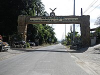
Welcome arch from Bauan

Municipal hall
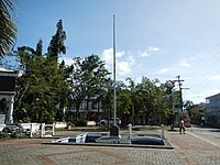
Plaza Mabini
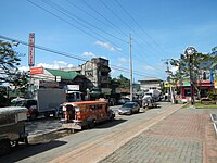
Downtown

Saint Francis of Paola Parish Church


References[]
- ^ Municipality of Mabini | (DILG)
- ^ "2015 Census of Population, Report No. 3 – Population, Land Area, and Population Density" (PDF). Philippine Statistics Authority. Quezon City, Philippines. August 2016. ISSN 0117-1453. Archived (PDF) from the original on May 25, 2021. Retrieved July 16, 2021.
- ^ a b c d Census of Population (2020). "Region IV-A (Calabarzon)". Total Population by Province, City, Municipality and Barangay. PSA. Retrieved July 8, 2021.
- ^ https://psa.gov.ph/sites/default/files/City%20and%20Municipal-level%20Small%20Area%20Poverty%20Estimates_%202009%2C%202012%20and%202015_0.xlsx; publication date: 10 July 2019; publisher: Philippine Statistics Authority.
- ^ a b CENTENNIAL OF MABINI, BATANGAS. phlpost.gov.ph (February 20, 2018)
- ^ "Province: Batangas". PSGC Interactive. Quezon City, Philippines: Philippine Statistics Authority. Retrieved November 12, 2016.
- ^ "Municipal: Mabini, Batangas". PSGC Interactive. Quezon City, Philippines: Philippine Statistics Authority. Retrieved January 8, 2016.
- ^ "An act creating the barrio of San Juan in the municipality of Mabini, province of Batangas". LawPH.com. Retrieved April 8, 2011.
- ^ a b Census of Population and Housing (2010). "Region IV-A (Calabarzon)". Total Population by Province, City, Municipality and Barangay. NSO. Retrieved June 29, 2016.
- ^ "Mabini: Average Temperatures and Rainfall". Meteoblue. Retrieved May 5, 2020.
- ^ Census of Population (2015). "Region IV-A (Calabarzon)". Total Population by Province, City, Municipality and Barangay. PSA. Retrieved June 20, 2016.
- ^ Censuses of Population (1903–2007). "Region IV-A (Calabarzon)". Table 1. Population Enumerated in Various Censuses by Province/Highly Urbanized City: 1903 to 2007. NSO.
- ^ "Province of Batangas". Municipality Population Data. Local Water Utilities Administration Research Division. Retrieved December 17, 2016.
- ^ "Poverty incidence (PI):". Philippine Statistics Authority. Retrieved December 28, 2020.
- ^ https://psa.gov.ph/sites/default/files/NSCB_LocalPovertyPhilippines_0.pdf; publication date: 29 November 2005; publisher: Philippine Statistics Authority.
- ^ https://psa.gov.ph/sites/default/files/2003%20SAE%20of%20poverty%20%28Full%20Report%29_1.pdf; publication date: 23 March 2009; publisher: Philippine Statistics Authority.
- ^ https://psa.gov.ph/sites/default/files/2006%20and%202009%20City%20and%20Municipal%20Level%20Poverty%20Estimates_0_1.pdf; publication date: 3 August 2012; publisher: Philippine Statistics Authority.
- ^ https://psa.gov.ph/sites/default/files/2012%20Municipal%20and%20City%20Level%20Poverty%20Estima7tes%20Publication%20%281%29.pdf; publication date: 31 May 2016; publisher: Philippine Statistics Authority.
- ^ https://psa.gov.ph/sites/default/files/City%20and%20Municipal-level%20Small%20Area%20Poverty%20Estimates_%202009%2C%202012%20and%202015_0.xlsx; publication date: 10 July 2019; publisher: Philippine Statistics Authority.
External links[]
 Media related to Mabini, Batangas at Wikimedia Commons
 Mabini travel guide from Wikivoyage
- Mabini Profile at PhilAtlas.com
- Philippine Standard Geographic Code
Places adjacent to Mabini, Batangas | ||||||||||||||||
|---|---|---|---|---|---|---|---|---|---|---|---|---|---|---|---|---|
| ||||||||||||||||
Batangas City (capital) | |
| Municipalities | |
| Component cities | |
- Municipalities of Batangas