Lobo, Batangas
Lobo | |
|---|---|
| Municipality of Lobo | |
 | |
 Seal | |
| Etymology: Wolf | |
| Nickname(s): Atis Capital of the Philippines[1] | |
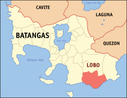 Map of Batangas with Lobo highlighted | |
show OpenStreetMap | |
 Lobo Location within the Philippines | |
| Coordinates: 13°39′N 121°15′E / 13.65°N 121.25°ECoordinates: 13°39′N 121°15′E / 13.65°N 121.25°E | |
| Country | Philippines |
| Region | Calabarzon |
| Province | Batangas |
| District | 2nd district |
| Founded | September 27, 1871 |
| Barangays | 26 (see Barangays) |
| Government | |
| • Type | Sangguniang Bayan |
| • Mayor | Gaudioso R. Manalo |
| • Vice Mayor | Virgilio R. Manalo |
| • Representative | Raneo E. Abu |
| • Municipal Council | show
Members |
| • Electorate | 26,994 voters (2019) |
| Area | |
| • Total | 175.03 km2 (67.58 sq mi) |
| Elevation | 109 m (358 ft) |
| Highest elevation | 905 m (2,969 ft) |
| Lowest elevation | 0 m (0 ft) |
| Population (2020 census) [4] | |
| • Total | 40,736 |
| • Density | 230/km2 (600/sq mi) |
| • Households | 8,945 |
| Economy | |
| • Income class | 3rd municipal income class |
| • Poverty incidence | 21.46% (2015)[5] |
| • Revenue | ₱105,424,167.74 (2016) |
| Service provider | |
| • Electricity | Batangas 2 Electric Cooperative (BATELEC 2) |
| Time zone | UTC+8 (PST) |
| ZIP code | 4229 |
| PSGC | |
| IDD : area code | +63 (0)43 |
| Climate type | tropical monsoon climate |
| Native languages | Tagalog |
| Website | www |


Lobo, officially the Municipality of Lobo (Tagalog: Bayan ng Lobo), is a 3rd class municipality in the province of Batangas, Philippines. According to the 2020 census, it has a population of 40,736 people. [4]
Etymology[]
The name "Lobo" may have come from:
The town was proclaimed as the "Atis Capital of the Philippines" through Resolution 2011-61 in September 2011.[1]
Geography[]
Lobo is located at 13°39′N 121°15′E / 13.65°N 121.25°E. The town is located near the southern tip of Batangas province, about 145 kilometres (90 mi) from Manila.
Lobo has white sand beaches whose ocean floor slopes gradually for nearly 200 metres (660 ft) before a drop-off.[citation needed] It also has protected mangrove forests and fish sanctuaries.
According to the Philippine Statistics Authority, the municipality has a land area of 175.03 square kilometres (67.58 sq mi) [6] constituting 5.61% of the 3,119.75-square-kilometre- (1,204.54 sq mi) total area of Batangas.
Barangays[]
Lobo is politically subdivided into 26 barangays.[7]
| PSGC | Barangay | Population | ±% p.a. | |||
|---|---|---|---|---|---|---|
| 2020 [4] | 2010 [8] | |||||
| 041015001 | Apar | 2.9% | 1,176 | 959 | 1.99% | |
| 041015002 | Balatbat | 5.9% | 2,400 | 2,137 | 1.13% | |
| 041015003 | Balibago | 8.5% | 3,454 | 2,967 | 1.48% | |
| 041015004 | Banalo | 6.2% | 2,515 | 2,195 | 1.32% | |
| 041015005 | Biga | 5.0% | 2,030 | 1,782 | 1.27% | |
| 041015006 | Bignay | 1.2% | 501 | 432 | 1.44% | |
| 041015007 | Calo | 2.3% | 918 | 913 | 0.05% | |
| 041015008 | Calumpit | 2.0% | 819 | 734 | 1.06% | |
| 041015009 | Fabrica | 5.0% | 2,056 | 1,742 | 1.61% | |
| 041015010 | Jaybanga | 4.6% | 1,873 | 1,652 | 1.22% | |
| 041015011 | Lagadlarin | 5.1% | 2,086 | 1,853 | 1.15% | |
| 041015012 | Mabilog na Bundok | 4.3% | 1,740 | 1,675 | 0.37% | |
| 041015013 | Malabrigo | 4.3% | 1,744 | 1,546 | 1.17% | |
| 041015014 | Malalim na Sanog | 0.8% | 306 | 205 | 3.95% | |
| 041015015 | Malapad na Parang | 3.6% | 1,461 | 1,455 | 0.04% | |
| 041015016 | Masaguitsit | 3.4% | 1,377 | 1,234 | 1.07% | |
| 041015017 | Nagtalongtong | 5.1% | 2,066 | 1,994 | 0.34% | |
| 041015018 | Nagtoctoc | 1.5% | 617 | 591 | 0.42% | |
| 041015019 | Olo‑olo | 3.5% | 1,406 | 1,377 | 0.20% | |
| 041015020 | Pinaghawanan | 1.2% | 488 | 419 | 1.48% | |
| 041015021 | San Miguel | 2.0% | 802 | 732 | 0.89% | |
| 041015022 | San Nicolas | 2.3% | 939 | 763 | 2.03% | |
| 041015023 | Sawang | 5.2% | 2,138 | 1,831 | 1.51% | |
| 041015024 | Soloc | 5.5% | 2,223 | 1,801 | 2.06% | |
| 041015025 | Tayuman | 4.1% | 1,652 | 1,409 | 1.55% | |
| 041015026 | Poblacion | 6.7% | 2,717 | 2,672 | 0.16% | |
| Total | 40,736 | 37,070 | 0.92% | |||
Climate[]
| hideClimate data for Lobo, Batangas | |||||||||||||
|---|---|---|---|---|---|---|---|---|---|---|---|---|---|
| Month | Jan | Feb | Mar | Apr | May | Jun | Jul | Aug | Sep | Oct | Nov | Dec | Year |
| Average high °C (°F) | 27 (81) |
28 (82) |
30 (86) |
32 (90) |
31 (88) |
30 (86) |
29 (84) |
29 (84) |
29 (84) |
29 (84) |
28 (82) |
27 (81) |
29 (84) |
| Average low °C (°F) | 21 (70) |
20 (68) |
21 (70) |
22 (72) |
24 (75) |
24 (75) |
24 (75) |
24 (75) |
24 (75) |
23 (73) |
22 (72) |
22 (72) |
23 (73) |
| Average precipitation mm (inches) | 52 (2.0) |
35 (1.4) |
27 (1.1) |
27 (1.1) |
82 (3.2) |
124 (4.9) |
163 (6.4) |
144 (5.7) |
145 (5.7) |
141 (5.6) |
100 (3.9) |
102 (4.0) |
1,142 (45) |
| Average rainy days | 12.0 | 8.1 | 8.8 | 9.7 | 17.9 | 22.6 | 26.2 | 24.5 | 24.6 | 22.0 | 16.7 | 14.9 | 208 |
| Source: Meteoblue [9] | |||||||||||||
Demographics[]
| Year | Pop. | ±% p.a. |
|---|---|---|
| 1903 | 5,781 | — |
| 1918 | 6,999 | +1.28% |
| 1939 | 8,964 | +1.19% |
| 1948 | 11,711 | +3.01% |
| 1960 | 15,197 | +2.19% |
| 1970 | 19,376 | +2.46% |
| 1975 | 22,092 | +2.67% |
| 1980 | 24,333 | +1.95% |
| 1990 | 26,881 | +1.00% |
| 1995 | 31,849 | +3.23% |
| 2000 | 33,909 | +1.35% |
| 2007 | 37,798 | +1.51% |
| 2010 | 37,070 | −0.71% |
| 2015 | 41,504 | +2.18% |
| 2020 | 40,736 | −0.37% |
| Source: Philippine Statistics Authority [10] [8] [11][12] | ||
In the 2020 census, Lobo had a population of 40,736. [4] The population density was 230 inhabitants per square kilometre (600/sq mi).
Economy[]
| Poverty Incidence of Lobo | |
| Source: Philippine Statistics Authority[13][14][15][16][17][18] | |
Government[]

Jurly Manalo and Renato Perez are the current mayor and vice mayor, respectively.[2]
The Municipal Councilors are:
- Dean Albert Araja
- Jan Michael Anyayahan
- Dok Tuklaw Dueñas
- Danny Diona
- Nilo Camo
- Ridian Dueñas
- Fred Umali
- Michael Cueto
Fish sanctuary[]

This section does not cite any sources. (November 2016) |
In 2005, the Lobo municipal government declared the Submarine Garden a fish sanctuary.
When the villagers, fishermen and local fisheries officials discovered that the sanctuary attracted more and more fishes, the entire 3 kilometres (1.9 mi) shoreline and 300 metres (980 ft) fronting the shores have been declared a protected area.
Fronting Calapan City in Oriental Mindoro province and nearby Verde Island, the view is dotted by small boats and passenger ships dragging tails of foam.[clarification needed]
Gallery[]

Malabrigo Point Lighthouse

Park

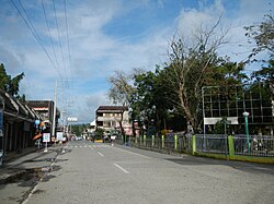
Downtown Lobo
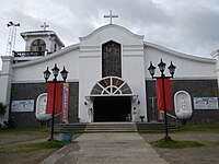
Saint Michael the Archangel Parish Church


References[]
- ^ Jump up to: a b "Government boosts atis production in Lobo". The Philippine Star. 29 November 2015. Retrieved 30 November 2016.
- ^ Jump up to: a b Municipality of Lobo | (DILG)
- ^ "2015 Census of Population, Report No. 3 – Population, Land Area, and Population Density" (PDF). Philippine Statistics Authority. Quezon City, Philippines. August 2016. ISSN 0117-1453. Archived (PDF) from the original on May 25, 2021. Retrieved July 16, 2021.
- ^ Jump up to: a b c d Census of Population (2020). "Region IV-A (Calabarzon)". Total Population by Province, City, Municipality and Barangay. PSA. Retrieved 8 July 2021.
- ^ https://psa.gov.ph/sites/default/files/City%20and%20Municipal-level%20Small%20Area%20Poverty%20Estimates_%202009%2C%202012%20and%202015_0.xlsx; publication date: 10 July 2019; publisher: Philippine Statistics Authority.
- ^ "Province: Batangas". PSGC Interactive. Quezon City, Philippines: Philippine Statistics Authority. Retrieved 12 November 2016.
- ^ "Municipal: Lobo, Batangas". PSGC Interactive. Quezon City, Philippines: Philippine Statistics Authority. Retrieved 8 January 2016.
- ^ Jump up to: a b Census of Population and Housing (2010). "Region IV-A (Calabarzon)". Total Population by Province, City, Municipality and Barangay. NSO. Retrieved 29 June 2016.
- ^ "Lobo: Average Temperatures and Rainfall". Meteoblue. Retrieved 5 May 2020.
- ^ Census of Population (2015). "Region IV-A (Calabarzon)". Total Population by Province, City, Municipality and Barangay. PSA. Retrieved 20 June 2016.
- ^ Censuses of Population (1903–2007). "Region IV-A (Calabarzon)". Table 1. Population Enumerated in Various Censuses by Province/Highly Urbanized City: 1903 to 2007. NSO.
- ^ "Province of Batangas". Municipality Population Data. Local Water Utilities Administration Research Division. Retrieved 17 December 2016.
- ^ "Poverty incidence (PI):". Philippine Statistics Authority. Retrieved 28 December 2020.
- ^ https://psa.gov.ph/sites/default/files/NSCB_LocalPovertyPhilippines_0.pdf; publication date: 29 November 2005; publisher: Philippine Statistics Authority.
- ^ https://psa.gov.ph/sites/default/files/2003%20SAE%20of%20poverty%20%28Full%20Report%29_1.pdf; publication date: 23 March 2009; publisher: Philippine Statistics Authority.
- ^ https://psa.gov.ph/sites/default/files/2006%20and%202009%20City%20and%20Municipal%20Level%20Poverty%20Estimates_0_1.pdf; publication date: 3 August 2012; publisher: Philippine Statistics Authority.
- ^ https://psa.gov.ph/sites/default/files/2012%20Municipal%20and%20City%20Level%20Poverty%20Estima7tes%20Publication%20%281%29.pdf; publication date: 31 May 2016; publisher: Philippine Statistics Authority.
- ^ https://psa.gov.ph/sites/default/files/City%20and%20Municipal-level%20Small%20Area%20Poverty%20Estimates_%202009%2C%202012%20and%202015_0.xlsx; publication date: 10 July 2019; publisher: Philippine Statistics Authority.
External links[]
| Wikimedia Commons has media related to Lobo, Batangas. |
| show Places adjacent to Lobo, Batangas |
|---|
| hide | |
|---|---|
Batangas City (capital) | |
| Municipalities | |
| Component cities | |
| show Authority control |
|---|
- Municipalities of Batangas