Rosario, Batangas
Rosario | |
|---|---|
| Municipality of Rosario | |
     (From top, left to right) Rosario, Batangas as viewed from nowhere, downtown Rosario, the Rosario Public Market, the Rosario Municipal Hall, and the Risen Christ Monument atop Tambol Hill. | |
 Seal | |
Nickname(s):
| |
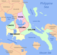
 Map of Batangas with Rosario highlighted | |
OpenStreetMap  | |
 Rosario Location within the Philippines | |
| Coordinates: 13°50′46″N 121°12′22″E / 13.846°N 121.206°ECoordinates: 13°50′46″N 121°12′22″E / 13.846°N 121.206°E | |
| Country | Philippines |
| Region | Calabarzon |
| Province | Batangas |
| District | 4th district |
| Founded | June 9, 1687 |
| Barangays | 48 (see Barangays) |
| Government | |
| • Type | Sangguniang Bayan |
| • Mayor | Manuel B. Alvarez |
| • Vice Mayor | Leovigildo K. Morpe |
| • Representative | Lianda B. Bolilia |
| • Municipal Council | Members |
| • Electorate | 74,408 voters (2019) |
| Area | |
| • Total | 226.88 km2 (87.60 sq mi) |
| Elevation | 148 m (486 ft) |
| Highest elevation | 232 m (761 ft) |
| Lowest elevation | 100 m (300 ft) |
| Population (2020 census) [4] | |
| • Total | 128,352 |
| • Density | 570/km2 (1,500/sq mi) |
| • Households | 25,971 |
| Economy | |
| • Income class | 1st municipal income class |
| • Poverty incidence | 11.55% (2015)[5] |
| • Revenue | ₱396,228,830.49 (2020) |
| • Assets | ₱865,569,762.68 (2020) |
| • Expenditure | ₱312,669,936.07 (2020) |
| • Liabilities | ₱172,879,377.73 (2020) |
| Service provider | |
| • Electricity | Batangas 2 Electric Cooperative (BATELEC 2) |
| Time zone | UTC+8 (PST) |
| ZIP code | 4225 |
| PSGC | |
| IDD : area code | +63 (0)43 |
| Native languages | Tagalog |
| Website | www |

Rosario, officially the Municipality of Rosario (Tagalog: Bayan ng Rosario), is a 1st class municipality in the province of Batangas, Philippines. According to the 2020 census, it has a population of 128,352 people. [4]
Rosario is considered as among the interior municipalities of the Batangas Bay Region comprising eleven municipalities and two cities whose catchment areas drain into the Batangas Bay. The town is also dubbed as "The Rice Granary of Batangas".[1]
History[]
This section includes a list of general references, but it remains largely unverified because it lacks sufficient corresponding inline citations. (December 2016) |
Accounts show that the origin of Rosario was a Christian settlement along the coast of Lobo. The settlement became prey to the pirate raids during the Moro wars of the 18th century.
The Moro or pirate raids forced the inhabitants of the settlement to the safety of the ravine and forest on the north-west bank of Kansahayan River (now the Municipality of Taysan). Here the settlement was relocated. However, at the height of the Moro Wars in the second half of the 18th century, the vicious Moro raids reached Kansahayan. In one of their forays the Parish Priest is said to be among those slain.
The inhabitants decided to leave Kansahayan. They headed farther north holding a novena and praying the rosary in the process of their flight. On the 9th night of the novena, the fleeing inhabitants reached the river bank of Tubig ng Bayan (a river originating from Lipa) in now the town of Padre Garcia. Here they finally settled. Living in peace and prosperity, the grateful town's people erected a stone church south of the river bank in honor of their benefactress, the Lady of the Most Holy Rosary Parish. The town was named Santo Rosario.
Santo Rosario was razed to the ground during the Philippine–American War. In the early American military occupation of Santo Rosario, a cavalry officer, Captain Daniel H. Boughton, came upon the big spring at the foot of Tombol Hill. He decided to relocate the town west of the spring, where Rosario's population center is now.
Official records show that on June 9, 1902, a council of prominent citizens of the town met under a mango tree beside Tombol Spring. On the spot they formally organized the municipal government of Rosario. The following assumed the first key positions of the town government:
- Geronimo Carandang (Presidente)
- Diego Rosales (Bise Presidente)
- Luis Greñas (Secretario)
- Leon Magtibay (Tesorero)
A wealthy landowner, Don Antonino Luancing donated for the town's public buildings and plaza.
Local historians were not unanimous as the exact date of the founding of this town. Certainly it was among those organized by the ecclesiastical authorities after the creation of Batangas as a province in 1581. It is generally believed to have come to the existence in 1687 while still located along the coast of Lobo during the term of Don Nicolas Morales as gobernadorcillo. Originally, Rosario comprised the whole parts of the municipalities of Lobo, Taysan, Ibaan, San Juan de Bolbok and the entire municipality of Padre Garcia.
The old settlement in Kansayahan now bears the name of Pinagbayanan, a thriving marketing post in the municipality of Taysan. The old town site of Santo Rosario had been named Lumang Bayan before it was renamed Padre Garcia when the latter was created and carved out Rosario in 1949 as a separate municipality.[6]
Geography[]
Rosario is located at 13°50′46″N 121°12′22″E / 13.846°N 121.206°E.
According to the Philippine Statistics Authority, the municipality has a land area of 226.88 square kilometres (87.60 sq mi) [7] constituting 7.27% of the 3,119.75-square-kilometre- (1,204.54 sq mi) total area of Batangas.
Climate[]
| Climate data for Rosario, Batangas | |||||||||||||
|---|---|---|---|---|---|---|---|---|---|---|---|---|---|
| Month | Jan | Feb | Mar | Apr | May | Jun | Jul | Aug | Sep | Oct | Nov | Dec | Year |
| Average high °C (°F) | 26 (79) |
27 (81) |
29 (84) |
31 (88) |
31 (88) |
30 (86) |
28 (82) |
28 (82) |
28 (82) |
28 (82) |
27 (81) |
26 (79) |
28 (83) |
| Average low °C (°F) | 20 (68) |
20 (68) |
20 (68) |
21 (70) |
23 (73) |
23 (73) |
23 (73) |
23 (73) |
23 (73) |
22 (72) |
21 (70) |
21 (70) |
22 (71) |
| Average precipitation mm (inches) | 52 (2.0) |
35 (1.4) |
27 (1.1) |
27 (1.1) |
82 (3.2) |
124 (4.9) |
163 (6.4) |
144 (5.7) |
145 (5.7) |
141 (5.6) |
100 (3.9) |
102 (4.0) |
1,142 (45) |
| Average rainy days | 12.0 | 8.1 | 8.8 | 9.7 | 17.9 | 22.6 | 26.2 | 24.5 | 24.6 | 22.0 | 16.7 | 14.9 | 208 |
| Source: Meteoblue [8] | |||||||||||||
Barangays[]
Rosario is politically subdivided into 48 barangays.[9] Malaya was formerly known as Munting Tubig.[10]
| PSGC | Barangay | Population | ±% p.a. | |||
|---|---|---|---|---|---|---|
| 2020 [4] | 2010 [11] | |||||
| 041021001 | Alupay | 3.4% | 4,314 | 3,991 | 0.80% | |
| 041021002 | Antipolo | 0.5% | 674 | 652 | 0.34% | |
| 041021003 | Bagong Pook | 4.5% | 5,757 | 5,165 | 1.12% | |
| 041021004 | Balibago | 1.8% | 2,280 | 2,147 | 0.62% | |
| 041021005 | Bayawang | 1.0% | 1,307 | 1,332 | −0.19% | |
| 041021006 | Baybayin | 1.8% | 2,323 | 2,288 | 0.16% | |
| 041021007 | Bulihan | 3.1% | 4,014 | 3,253 | 2.19% | |
| 041021008 | Cahigam | 1.9% | 2,450 | 1,907 | 2.61% | |
| 041021009 | Calantas | 1.3% | 1,634 | 1,560 | 0.48% | |
| 041021010 | Colongan | 1.3% | 1,727 | 1,655 | 0.44% | |
| 041021011 | Itlugan | 3.6% | 4,677 | 4,386 | 0.66% | |
| 041021012 | Lumbangan | 1.2% | 1,587 | 1,200 | 2.92% | |
| 041021013 | Maalas‑As | 1.5% | 1,932 | 1,776 | 0.87% | |
| 041021014 | Mabato | 1.4% | 1,794 | 1,660 | 0.80% | |
| 041021015 | Mabunga | 1.4% | 1,838 | 1,713 | 0.73% | |
| 041021016 | Macalamcam A | 0.7% | 959 | 1,058 | −1.01% | |
| 041021017 | Macalamcam B | 1.4% | 1,765 | 1,480 | 1.83% | |
| 041021018 | Malaya | 1.2% | 1,555 | 1,482 | 0.50% | |
| 041021019 | Maligaya | 0.7% | 913 | 790 | 1.50% | |
| 041021020 | Marilag | 2.3% | 2,898 | 2,525 | 1.43% | |
| 041021021 | Masaya | 3.1% | 3,967 | 3,217 | 2.18% | |
| 041021022 | Matamis | 0.5% | 592 | 689 | −1.55% | |
| 041021023 | Mavalor | 1.2% | 1,549 | 1,481 | 0.46% | |
| 041021024 | Mayuro | 1.9% | 2,411 | 2,068 | 1.59% | |
| 041021025 | Namuco | 3.9% | 4,992 | 4,314 | 1.51% | |
| 041021026 | Namunga | 4.1% | 5,276 | 4,785 | 1.01% | |
| 041021027 | Natu | 2.1% | 2,721 | 2,392 | 1.33% | |
| 041021028 | Nasi | 1.6% | 2,048 | 1,925 | 0.64% | |
| 041021029 | Palakpak | 0.7% | 851 | 852 | −0.01% | |
| 041021030 | Pinagsibaan | 2.7% | 3,422 | 2,999 | 1.37% | |
| 041021031 | Barangay A (Poblacion) | 0.9% | 1,122 | 1,082 | 0.37% | |
| 041021032 | Barangay B (Poblacion) | 1.1% | 1,376 | 1,195 | 1.46% | |
| 041021033 | Barangay C (Poblacion) | 0.7% | 943 | 968 | −0.27% | |
| 041021034 | Barangay D (Poblacion) | 0.7% | 932 | 1,039 | −1.11% | |
| 041021035 | Barangay E (Poblacion) | 1.8% | 2,276 | 2,174 | 0.47% | |
| 041021036 | Putingkahoy | 2.2% | 2,811 | 2,612 | 0.76% | |
| 041021037 | Quilib | 3.1% | 4,041 | 3,157 | 2.57% | |
| 041021038 | Salao | 1.8% | 2,303 | 2,121 | 0.85% | |
| 041021039 | San Carlos | 2.9% | 3,771 | 3,345 | 1.24% | |
| 041021040 | San Ignacio | 1.5% | 1,954 | 1,780 | 0.96% | |
| 041021041 | San Isidro | 3.0% | 3,811 | 3,521 | 0.82% | |
| 041021042 | San Jose | 1.6% | 2,075 | 1,874 | 1.05% | |
| 041021043 | San Roque | 3.0% | 3,900 | 3,648 | 0.69% | |
| 041021044 | Santa Cruz | 2.6% | 3,301 | 3,055 | 0.80% | |
| 041021045 | Timbugan | 1.6% | 2,077 | 1,946 | 0.67% | |
| 041021046 | Tiquiwan | 1.4% | 1,736 | 1,654 | 0.50% | |
| 041021047 | Leviste (Tubahan) | 1.4% | 1,753 | 1,656 | 0.59% | |
| 041021048 | Tulos | 1.8% | 2,355 | 1,992 | 1.74% | |
| Total | 128,352 | 105,561 | 2.03% | |||
Clusters[]
For purposes of community organization and effective delivery of social development projects, the Office for Sustainable Development under supervision of the Office of the Municipal Mayor in 1995, divided the 48 barangays into 8 barangay clusters with 6 member barangays each.[12]
| Cluster | Barangays |
|---|---|
| South East I |
|
| North East II |
|
| East III |
|
| East IV |
|
| Central V |
|
| West Central VI |
|
| East Central VII |
|
| West VIII |
|
This system was patterned after the resolutions traditionally passed by the Sangguniang Bayan as part of its organizational plan following the general elections when new members are elected into office for a new term.
Consequently, the barangay cluster arrangement was adopted and served as the framework for land use development strategies enunciated under the Comprehensive Land Use Plan of Rosario, Batangas for Planning Period 2000-2010 (CLUP).[13]
Demographics[]
| Year | Pop. | ±% p.a. |
|---|---|---|
| 1903 | 8,326 | — |
| 1918 | 22,174 | +6.75% |
| 1939 | 34,130 | +2.07% |
| 1948 | 36,020 | +0.60% |
| 1960 | 32,868 | −0.76% |
| 1970 | 42,704 | +2.65% |
| 1975 | 47,298 | +2.07% |
| 1980 | 54,252 | +2.78% |
| 1990 | 66,923 | +2.12% |
| 1995 | 74,976 | +2.15% |
| 2000 | 86,110 | +3.01% |
| 2007 | 95,785 | +1.48% |
| 2010 | 105,561 | +3.60% |
| 2015 | 116,764 | +1.94% |
| 2020 | 128,352 | +1.88% |
| Source: Philippine Statistics Authority [14] [11] [15][16] | ||
In the 2020 census, Rosario had a population of 128,352. [4] The population density was 570 inhabitants per square kilometre (1,500/sq mi).
Economy[]
| Poverty Incidence of Rosario | |
| Source: Philippine Statistics Authority[17][18][19][20][21][22] | |
Education[]
The Leon Manigbas Elementary School (LMES)[23] is a government primary school located in San Jose, Rosario, Batangas, Philippines.[24] The "school code" is 107578.[25] As of 2020, the principal is Ella Castillo, and the school colors are Blue and Yellow.[26]
Leon Manigbas Elementary School was established in 1993 and has existed for 27 years as of 2020.[27]
Government[]

The current set of municipal officials were elected during the 2019 General Elections; their term is set to expire in 2022.
- Municipal Mayor: Manuel B. Alvarez
- Vice Mayor: Leovigildo K. Morpe
- Sangguniang Bayan members:
- Atanacio G. Zara
- Angelito M. Gulfo
- Angel B. Alvarez, Sr.
- Aldwin G. Garcia
- Arnold T. Austria
- Christopher A. Conti
- Marilou M. Villapando-Magdangal
- Edward B. Aguilar
Notable people[]
- Jovit Baldivino – Pilipinas Got Talent Season 1 winner
Gallery[]

Rosario Night Market

Hall of Justice
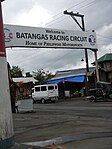
Batangas Racing Circuit arch in Barangay Maligaya

Holy Family Parish in Barangay Alupay

The Grotto

Tombol Hill


Sister cities[]
References[]
- ^ a b Ganzon, Tina (9 Jun 2009). "Batangas hosts 'Sinukmani' festival". ABS-CBN News. ABS-CBN Southern Tagalog. Archived from the original on 10 December 2016. Retrieved 10 December 2016.
- ^ Municipality of Rosario | (DILG)
- ^ "2015 Census of Population, Report No. 3 – Population, Land Area, and Population Density" (PDF). Philippine Statistics Authority. Quezon City, Philippines. August 2016. ISSN 0117-1453. Archived (PDF) from the original on May 25, 2021. Retrieved July 16, 2021.
- ^ a b c d Census of Population (2020). "Region IV-A (Calabarzon)". Total Population by Province, City, Municipality and Barangay. PSA. Retrieved 8 July 2021.
- ^ https://psa.gov.ph/sites/default/files/City%20and%20Municipal-level%20Small%20Area%20Poverty%20Estimates_%202009%2C%202012%20and%202015_0.xlsx; publication date: 10 July 2019; publisher: Philippine Statistics Authority.
- ^ "History of the Municipality of Rosario". Archived from the original on 2012-02-04. Retrieved 2012-01-31.
- ^ "Province: Batangas". PSGC Interactive. Quezon City, Philippines: Philippine Statistics Authority. Retrieved 12 November 2016.
- ^ "Rosario: Average Temperatures and Rainfall". Meteoblue. Retrieved 5 May 2020.
- ^ "Municipal: Rosario, Batangas". PSGC Interactive. Quezon City, Philippines: Philippine Statistics Authority. Retrieved 8 January 2016.
- ^ "An Act Changing the Name of the Barrio of Munting Tubig in the Municipality of Rosario, Province of Batangas, to Malaya". LawPH.com. Retrieved 2011-04-09.
- ^ a b Census of Population and Housing (2010). "Region IV-A (Calabarzon)". Total Population by Province, City, Municipality and Barangay. NSO. Retrieved 29 June 2016.
- ^ Villar, Rodolfo G.; Quizon, Manuel Luis; Barbosa-Bianzon, Francia (1996). Minimum Basic Needs Baseline Survey Consolidated Report. Municipality of Rosario, Batangas, Philippines.
- ^ Municipal Land Use Committee; Office of the Municipal Planning and Development Coordinator (June 2000). Comprehensive Land Use Plan of Rosario, Batangas for Planning Period: 2000-2010. Municipality of Rosario, Batangas, Philippines.
- ^ Census of Population (2015). "Region IV-A (Calabarzon)". Total Population by Province, City, Municipality and Barangay. PSA. Retrieved 20 June 2016.
- ^ Censuses of Population (1903–2007). "Region IV-A (Calabarzon)". Table 1. Population Enumerated in Various Censuses by Province/Highly Urbanized City: 1903 to 2007. NSO.
- ^ "Province of Batangas". Municipality Population Data. Local Water Utilities Administration Research Division. Retrieved 17 December 2016.
- ^ "Poverty incidence (PI):". Philippine Statistics Authority. Retrieved 28 December 2020.
- ^ https://psa.gov.ph/sites/default/files/NSCB_LocalPovertyPhilippines_0.pdf; publication date: 29 November 2005; publisher: Philippine Statistics Authority.
- ^ https://psa.gov.ph/sites/default/files/2003%20SAE%20of%20poverty%20%28Full%20Report%29_1.pdf; publication date: 23 March 2009; publisher: Philippine Statistics Authority.
- ^ https://psa.gov.ph/sites/default/files/2006%20and%202009%20City%20and%20Municipal%20Level%20Poverty%20Estimates_0_1.pdf; publication date: 3 August 2012; publisher: Philippine Statistics Authority.
- ^ https://psa.gov.ph/sites/default/files/2012%20Municipal%20and%20City%20Level%20Poverty%20Estima7tes%20Publication%20%281%29.pdf; publication date: 31 May 2016; publisher: Philippine Statistics Authority.
- ^ https://psa.gov.ph/sites/default/files/City%20and%20Municipal-level%20Small%20Area%20Poverty%20Estimates_%202009%2C%202012%20and%202015_0.xlsx; publication date: 10 July 2019; publisher: Philippine Statistics Authority.
- ^ "Leon Manigbas Elementary School, Rosario (2020)". www.schoolandcollegelistings.com. Retrieved 2020-12-08.
- ^ https://www.comelec.gov.ph/php-tpls-attachments/2019NLE/POP/BATANGAS_POP.pdf
- ^ "Leon M. Manigbas Elementary School, Rosario, Batangas".
- ^ Leon Manigbas
- ^ "Leon Manigbas Elementary School, Rizal". vymaps.com. Retrieved 2020-11-16.
- ^ Tayona, Glenda; Silubrico, Ruby (25 August 2018). "Iloilo to showcase culture to 'sister cities' tonight". Panay News. Archived from the original on 9 April 2019. Retrieved 9 April 2019.
External links[]
| Wikimedia Commons has media related to Rosario, Batangas. |
- Official website
- Rosario Profile at PhilAtlas.com
- Philippine Standard Geographic Code
- Rosario Batangas Information on BlogSpot
- RosarioBatangas.com
- Barangay Clusters
Places adjacent to Rosario, Batangas | ||||||||||||||||
|---|---|---|---|---|---|---|---|---|---|---|---|---|---|---|---|---|
| ||||||||||||||||
- Municipalities of Batangas