General Mariano Alvarez
hideThis article has multiple issues. Please help or discuss these issues on the talk page. (Learn how and when to remove these template messages)
|
General Mariano Alvarez | |
|---|---|
| Municipality of General Mariano Alvarez | |
 GMA Municipal Hall | |
 Flag  Seal | |
| Nickname(s): GMA Mushroom Capital of Cavite | |
| Motto(s): Bukas na Pamahalaan, Serbisyong Pambayan (Open Government, Service to the People) | |
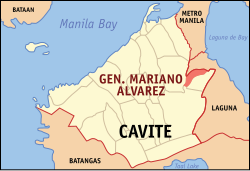 Map of Cavite with General Mariano Alvarez highlighted | |
show OpenStreetMap | |
 General Mariano Alvarez Location within the Philippines | |
| Coordinates: 14°18′N 121°00′E / 14.3°N 121°ECoordinates: 14°18′N 121°00′E / 14.3°N 121°E | |
| Country | Philippines |
| Region | Calabarzon |
| Province | Cavite |
| District | 5th district |
| Founded | March 14, 1981 |
| Named for | Mariano Álvarez |
| Barangays | 27 (see Barangays) |
| Government | |
| • Type | Sangguniang Bayan |
| • Mayor | Maricel E. Torres |
| • Vice Mayor | Angela Lenin E. Paycana |
| • Representative | Dahlia A. Loyola |
| • Municipal Council | show
Members |
| • Electorate | 91,474 voters (2019) |
| Area | |
| • Total | 11.40 km2 (4.40 sq mi) |
| Elevation | 107 m (351 ft) |
| Highest elevation | 243 m (797 ft) |
| Lowest elevation | 11 m (36 ft) |
| Population (2020 census) [3] | |
| • Total | 172,433 |
| • Rank | 12 out of 1,489 Municipalities |
| • Density | 15,000/km2 (39,000/sq mi) |
| • Households | 33,914 |
| Economy | |
| • Income class | 1st municipal income class |
| • Poverty incidence | 9.62% (2015)[4] |
| • Revenue | ₱288,458,823.95 (2016) |
| Service provider | |
| • Electricity | Manila Electric Company (Meralco) |
| Time zone | UTC+8 (PST) |
| ZIP code | 4117 |
| PSGC | |
| IDD : area code | +63 (0)46 |
| Climate type | tropical monsoon climate |
| Native languages | Tagalog |
| Website | www |


General Mariano Alvarez, officially the Municipality of General Mariano Alvarez (Tagalog: Bayan ng Heneral Mariano Alvarez) and often shortened as GMA, is a 1st class municipality in the province of Cavite, Philippines. According to the 2020 census, it has a population of 172,433 people. [3]
The municipality was named after General Mariano Álvarez, a native of the town of Noveleta, Cavite. With an area of just 11.40 square kilometres (4.40 sq mi), it is the second most densely populated municipality in Cavite after Rosario.
History[]
General Mariano Alvarez was formerly a part of Carmona, Cavite. The province's third planned community was previously called Carmona Resettlement Project and was under the direct management of the People's Homesite and Housing Corporation (PHHC). The project started in March 1968 because of the need to clear the Quezon Memorial Park, Diliman, Quezon City of different shanties and other illegal constructions built on it. By 1974, the project lots became part of the full-fledged communities of poor and middle class residents coming from Quezon City, Manila, Makati and Parañaque.
Due to the popular clamor of the residents of the aforementioned resettlement areas towards the conversion of their locality into an independent municipality, the ten (10) Barangay Council of the communities of the then San Gabriel and San Jose, submitted resolution expressing their desire to the Sangguniang Bayan of Carmona which in turn favorably endorsed the idea through Resolutions No. 56-S-1978. By 1979, the idea soon began to speed up as the provincial deputy to the Interim Batasang Pambansa, Helena Benitez, and MP for Eastern Visayas and concurrent Minister of Local Government, Jose Roño, pursued the separation of the growing communities, whose several of their residents were now working in the growing industrial factories in Carmona town and in other parts of the province, as well as in agriculture and small enterprises.
The Municipality of General Mariano Alvarez came into existence upon the ratification by the majority votes cast in a plebiscite at Carmona and its duly constituted barangays within a period of 180 days after the approval of Batas Pambansa 75 and Parliamentary Bill No. 631 after which then President Ferdinand Marcos appointed the first set of local officials for the said town.
Upon the effectivity of the specified legal acts converting Barangays San Jose and San Gabriel into the Municipality of General Mariano Alvarez, its proportional share in the obligation of funds, assets and other properties of Carmona was transferred to the newly created municipality upon the recommendation of the Commission of Audit, which was approved on June 30, 1980. The new municipality's first officials were officially inaugurated on March 14, 1981.
The new town, for the next few years, was composed of the Resettlement areas of Barangays San Jose, San Gabriel and a portion of Cabilang Baybay. Barangay San Jose consisted of areas A and B while Barangay San Gabriel consisted of Areas C, D, E, F, G, H, I, J, and K.
In 2006, the municipality celebrated its 25th anniversary with a line-up of activities participated in by the municipality's residents. Gen. Mariano Alvarez also takes pride in being known as the “Mushroom Capital of Cavite” because of the mushroom culture facilities in the town. Mushrooms have become the town's main product in line with the “One Town, One Product” program of the Philippine national government.[citation needed]
Geography[]
The Municipality of General Mariano Alvarez is at the north-eastern boundaries of Cavite Province with Laguna Province. It is bounded on the north by the City of San Pedro, Laguna on the east by the Municipality of Carmona, on the west by the City of Dasmariñas and on the south by the Municipality of Silang. General Mariano Alvarez is approximately 42 kilometres (26 mi) south of the City of Manila and 17 kilometres (11 mi) east of Trece Martires City, the capital of the province.
Land area[]
General Mariano Alvarez has a total land area of 938.0137 hectares more or less as per Batasang Pambansa Bilang 76 dated June 13, 1980, which created the municipality. These areas are currently occupied by 27 barangays of which five are considered Poblacion barangays and 22 others are regular barangays.
Topography[]
The municipality has elongated shape with a north, north-eastern orientation. It has a total length of about 7,040 meters and a width of about 780 meters at its smallest and 1,720 meters at its widest. The terrain is relatively flat plain from the south starting at the Governor's Drive running north covering about one third of the municipality's length at Poblacion 5. From this point the terrain gradually begin to gently slope in one direction in the middle portion of the municipality, undulating and rolling to more than one direction towards the north-eastern barangay of Epifanio Malia, portion of Francisco de Castro, Francisco Reyes and San Jose.
Inland water bodies serve as natural boundaries with neighboring municipalities and drain its surface waters towards Manila Bay and Laguna Bay. These are Embarcadero River on the western boundaries with Dasmarinas and San Gabriel River on the eastern boundaries with Carmona. A major tributary, of San Gabriel River traverse the inner areas of the municipality from Francisco de Castro and Southwoods to Jacinto Lumbreras. The same tributary branches out at Inocencio Salud to serve as boundaries between the barangay of Col. J.P Elises and Aldiano Olaes, on the eastern side. Small streams crisscross the landscape forming natural drainage where waste drains from Manila Bay and Laguna de Bay. These water bodies run and form deep gullies which gave the land a mass ridge-like formation. Considering the height and mass of the water bodies, the ridge-like formation are highly elevated. Thus, the terrain as described above.
Man-made physical changes, includes the presence of the Congressional Road which stretcher on full length of the municipality from the Governor's Drive or the national highway in the south to Francisco de Castro on the north. It runs parallel to the water bodies mentioned above on the eastern side of the municipality. Structures such as houses, schools, commercial establishments, institutional buildings and industrial firms are located among this road, on gully sides of water bodies and the top flat plain areas of the ridge. Open grasslands and agricultural areas can be found on the western near central portion of the municipality.
Slope[]
The slope of the municipality ranges from 0-3% to 3-8% broad to level nearly level are classified under 0-3% slope. These are generally the flat plain level lands on the southern portion from the Governor's Drive extending inwards covering all Poblacion barangays, Gavino Maderan, Jacinto Lumbreras, Ramon Cruz, San Gabriel and Severino delas Alas, 3-5% slope are gently sloping areas with land sloping in one general direction. This areas compress the central portion of the municipality from Barangay Kapitan Kua, Pantaleon Granados and Marcelino Mimeje to Aldiano Olaes, Col. Jose P. Elises and portion of Foerillo Calimag, Macario Dacon and Benjamin Tirona. These also include Inocencio Salud and Bernardo Pulido.
Areas on the north and north-eastern side have slope of 5-8%. These are gently undulating and rolling lands sloping in more than one general direction. Portion of Baranay Feorillo Calimag, Macario Dacon and Benjamin Tirona and barangay of Francisco de Castro, Francisco Reyes, Epifanio Malia, Tiniente Tiago, Nicolasa Virata, Gregoria de Jesus and San Jose.
Climate[]
| hideClimate data for General Mariano Alvarez, Cavite | |||||||||||||
|---|---|---|---|---|---|---|---|---|---|---|---|---|---|
| Month | Jan | Feb | Mar | Apr | May | Jun | Jul | Aug | Sep | Oct | Nov | Dec | Year |
| Average high °C (°F) | 28 (82) |
29 (84) |
31 (88) |
32 (90) |
31 (88) |
29 (84) |
28 (82) |
28 (82) |
28 (82) |
28 (82) |
28 (82) |
28 (82) |
29 (84) |
| Average low °C (°F) | 19 (66) |
19 (66) |
20 (68) |
21 (70) |
23 (73) |
23 (73) |
23 (73) |
23 (73) |
23 (73) |
22 (72) |
21 (70) |
20 (68) |
21 (70) |
| Average precipitation mm (inches) | 10 (0.4) |
10 (0.4) |
12 (0.5) |
27 (1.1) |
94 (3.7) |
153 (6.0) |
206 (8.1) |
190 (7.5) |
179 (7.0) |
120 (4.7) |
54 (2.1) |
39 (1.5) |
1,094 (43) |
| Average rainy days | 5.2 | 4.5 | 6.4 | 9.2 | 19.7 | 24.3 | 26.9 | 25.7 | 24.4 | 21.0 | 12.9 | 9.1 | 189.3 |
| Source: Meteoblue [5] | |||||||||||||
Barangays[]
General Mariano Alvarez is currently divided into 27 barangays. Five of the current barangays are classified as poblacion barangays, or those that are within the municipality's central area. The 22 others are ordinary barangays.
The 27 barangays are as follows:[6]
- Aldiano Olaes (Area F)
- Poblacion 1 (Area I)
- Poblacion 2 (Area I)
- Poblacion 3 (Area I)
- Poblacion 4 (Area I)
- Poblacion 5 (Area G)
- Benjamin Tirona (Area D)
- Bernardo Pulido (Area H)
- Epifanio Malia (Area D)
- Francisco De Castro (Formerly Area B)
- Francisco Reyes (Formerly Area A)(Metro San Jose)
- Fiorello Calimag (Area C)
- Gavino Maderan (Area J)
- Gregoria De Jesus (Formerly Area A)(Metro San Jose)
- Inocencio Salud (Area F)
- Jacinto Lumbreras (Area J)
- Kapitan Kua (Area F)
- Koronel Jose P. Elises (Area E)
- Macario Dacon (Area D)
- Marcelino Memije (Area H)
- Nicolasa Virata (Formerly Area A)(Metro San Jose)
- Pantaleon Granados (Area G)
- Ramon Cruz Sr. (Area J)
- San Gabriel (Area K)
- San Jose (Formerly Area A)(Metro San Jose)
- Severino De Las Alas (Area J)
- Tiniente Tiago (Formerly Area A)(Metro San Jose)
These Barangays were created out of the former residential areas in 1985. Except for the town proper, many are named after the first area barangay captains and people connected to the life and work of General Alvarez.
Demographics[]
| Year | Pop. | ±% p.a. |
|---|---|---|
| 1990 | 65,977 | — |
| 1995 | 86,824 | +5.28% |
| 2000 | 112,446 | +5.70% |
| 2007 | 136,613 | +2.72% |
| 2010 | 138,540 | +0.51% |
| 2015 | 155,143 | +2.18% |
| 2020 | 172,433 | +2.10% |
| Source: Philippine Statistics Authority [7] [8] [9][10] | ||
In the 2020 census, the population of Gen. Mariano Alvarez was 172,433 people, [3] with a density of 15,000 inhabitants per square kilometre or 39,000 inhabitants per square mile.
Religion[]
The majority of the inhabitants are Roman Catholics and Protestants. There are some such as: Iglesia Ni Cristo, United Pentecostal Church Int'l., Apostolic Church of Jesus Christ Phils. Inc., Family Tabernacle of Jesus Christ Int'l. , Members Church of God International, Seventh Day Adventist and many others.
Economy[]
| Poverty Incidence of General Mariano Alvarez | |
| Source: Philippine Statistics Authority[11][12][13][14][15][16] | |
List of local chief executives[]
- Leoniso G. Virata (1981–1986; 1988–1998)
- Tomas E. Abueg (officer-in-charge, 1986–1987)
- Severino P. Tamala (officer-in-charge, 1987–1988)
- Antonio G. Virata (1998–2001)
- Walter D. Echevarria, Jr. (2001–2010; 2013-2021)
- Leonisa Joana B. Virata (June 30, 2010 – 2013)
- Maricel E. Torres (officer-in-charge, 2020-2021,) (assumed office, August 3, 2021-present)
References[]
- ^ Municipality of General Mariano Alvarez | (DILG)
- ^ "2015 Census of Population, Report No. 3 – Population, Land Area, and Population Density" (PDF). Philippine Statistics Authority. Quezon City, Philippines. August 2016. ISSN 0117-1453. Archived (PDF) from the original on May 25, 2021. Retrieved July 16, 2021.
- ^ Jump up to: a b c Census of Population (2020). "Region IV-A (Calabarzon)". Total Population by Province, City, Municipality and Barangay. PSA. Retrieved 8 July 2021.
- ^ https://psa.gov.ph/sites/default/files/City%20and%20Municipal-level%20Small%20Area%20Poverty%20Estimates_%202009%2C%202012%20and%202015_0.xlsx; publication date: 10 July 2019; publisher: Philippine Statistics Authority.
- ^ "General Mariano Alvarez: Average Temperatures and Rainfall". Meteoblue. Retrieved 12 May 2020.
- ^ "Municipality: GEN. MARIANO ALVAREZ". Philippine Statistics Authority (National Statistical Coordination Board). Archived from the original on December 24, 2016. Retrieved May 24, 2016.
- ^ Census of Population (2015). "Region IV-A (Calabarzon)". Total Population by Province, City, Municipality and Barangay. PSA. Retrieved 20 June 2016.
- ^ Census of Population and Housing (2010). "Region IV-A (Calabarzon)". Total Population by Province, City, Municipality and Barangay. NSO. Retrieved 29 June 2016.
- ^ Censuses of Population (1903–2007). "Region IV-A (Calabarzon)". Table 1. Population Enumerated in Various Censuses by Province/Highly Urbanized City: 1903 to 2007. NSO.
- ^ "Province of Cavite". Municipality Population Data. Local Water Utilities Administration Research Division. Retrieved 17 December 2016.
- ^ "Poverty incidence (PI):". Philippine Statistics Authority. Retrieved 28 December 2020.
- ^ https://psa.gov.ph/sites/default/files/NSCB_LocalPovertyPhilippines_0.pdf; publication date: 29 November 2005; publisher: Philippine Statistics Authority.
- ^ https://psa.gov.ph/sites/default/files/2003%20SAE%20of%20poverty%20%28Full%20Report%29_1.pdf; publication date: 23 March 2009; publisher: Philippine Statistics Authority.
- ^ https://psa.gov.ph/sites/default/files/2006%20and%202009%20City%20and%20Municipal%20Level%20Poverty%20Estimates_0_1.pdf; publication date: 3 August 2012; publisher: Philippine Statistics Authority.
- ^ https://psa.gov.ph/sites/default/files/2012%20Municipal%20and%20City%20Level%20Poverty%20Estima7tes%20Publication%20%281%29.pdf; publication date: 31 May 2016; publisher: Philippine Statistics Authority.
- ^ https://psa.gov.ph/sites/default/files/City%20and%20Municipal-level%20Small%20Area%20Poverty%20Estimates_%202009%2C%202012%20and%202015_0.xlsx; publication date: 10 July 2019; publisher: Philippine Statistics Authority.
- Fontanilla, M. et al. (2001). Comprehensive Land Use Plan of the Municipality of Gen. Mariano Alvarez, Cavite. (Unpublished report.) Cavite: Municipal Government of Gen. Mariano Alvarez.
- Commission on Elections (2007, October 30). List of Winning Candidates in the October 29, 2007 Synchronized Barangay and Sangguniang Kabataan Elections. (Unpublished report._ Cavite: Office of the Election Officer, COMELEC-Gen. Mariano Alvarez.
External links[]
| Wikimedia Commons has media related to General Mariano Alvarez, Cavite. |
- General Mariano Alvarez Profile at PhilAtlas.com
- Official website
- Official Website of the Provincial Government of Cavite
- Philippine Standard Geographic Code
- Philippine Census Information
| show Places adjacent to General Mariano Alvarez |
|---|
| show Articles Related to General Mariano Alvarez, Cavite |
|---|
- Municipalities of Cavite