Nagcarlan
Nagcarlan | |
|---|---|
| Municipality of Nagcarlan | |
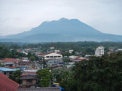 Mount San Cristobal and Nagcarlan Town Proper | |
 Seal | |
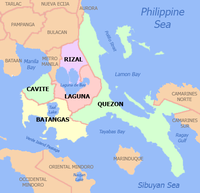
 Map of Laguna with Nagcarlan highlighted | |
show OpenStreetMaNagcap | |
 Nagcarlan Location within the Philippines | |
| Coordinates: 14°08′11″N 121°24′59″E / 14.1364°N 121.4165°ECoordinates: 14°08′11″N 121°24′59″E / 14.1364°N 121.4165°E | |
| Country | Philippines |
| Region | Calabarzon |
| Province | Laguna |
| District | 3rd district |
| Founded | August 24, 1583 [1] |
| Barangays | 52 (see Barangays) |
| Government | |
| • Type | Sangguniang Bayan |
| • Mayor | Lourdes J. Arcasetas |
| • Vice Mayor | Rexon V. Arevalo |
| • Representative | Marisol A. Sampelo |
| • Municipal Council | show
Members |
| • Electorate | 40,988 voters (2019) |
| Area | |
| • Total | 78.10 km2 (30.15 sq mi) |
| Elevation | 333 m (1,093 ft) |
| Highest elevation | 2,167 m (7,110 ft) |
| Lowest elevation | 5 m (16 ft) |
| Population (2020 census) [4] | |
| • Total | 64,866 |
| • Density | 830/km2 (2,200/sq mi) |
| • Households | 15,212 |
| Demonym(s) | Nagcarlangin |
| Economy | |
| • Income class | 2nd municipal income class |
| • Poverty incidence | 5.60% (2015)[5] |
| • Revenue | ₱138,096,175.86 (2016) |
| Service provider | |
| • Electricity | Manila Electric Company (Meralco) |
| Time zone | UTC+8 (PST) |
| ZIP code | 4002 |
| PSGC | |
| IDD : area code | +63 (0)49 |
| Climate type | tropical monsoon climate |
| Native languages | Tagalog |


Nagcarlan, officially the Municipality of Nagcarlan (Tagalog: Bayan ng Nagcarlan), is a 2nd class municipality in the province of Laguna, Philippines. According to the 2020 census, it has a population of 64,866 people. [4]
It is 16 kilometres (9.9 mi) northeast of San Pablo City, or 103 kilometres (64 mi) south of Manila. The town is home to the Nagcarlan Underground Cemetery, one of the most important cemeteries in the Philippines which has been declared as a National Historical Landmark by virtue of Presidential Decree no. 260, dated August 1, 1973 with amendments by Administrative Order 1505, dated June 11, 1978. Since the declaration, no more burials were allowed in the cemetery. It underwent renovations before it was again opened to the public during the unveiling of the marker on October 24, 1981. The oldest tomb is dated 1886 while the last interment was in 1982 when it was formally declared as a National Historical Landmark.
Etymology[]
According to origin, the name Nagcarlan came from the name of a famous rich and generous woman by Ana Kalang or Ana Panalangin was a native woman who was known for her golden salakot and cane which she always carried when walking around town. She was well-respected by the townfolk not just for her wealth but also for the help she extends to those in need.One day, a Spaniard came to her house and upon looking out of the window, he saw branches swaying and hitting one another, and so he asked what was going on. Ana Kalang answered and said "nagkakalang sila". The word was repeatedly mispronounced by the Spaniards until it became Nagcarlan, which is now the name of the town. It was also said that saw the Virgin Sta. Ana who took the poison out of the lanzones fruits to make them edible. There is a popular legend about how the town got its name.
The Legend of the Hidden Tunnel of Nagcarlan[]
Nagcarlan was first colonized in 1571 by Juan de Salcedo, grandson of Miguel López de Legazpi. It was founded by Franciscan priests Juan de Plasencia and in 1578. The church of Nagcarlan was first built from light materials such as nipa and wood in 1583 under the chaplaincy of its first priest, Father Tomas de Miranda who also pioneered the cultivation of wheat in the country and was dedicated to Saint Bartholomew.Fr. Vicente Velloc supervised the establishment of a cemetery in Nagcarlan in 1845 below Mt. San Cristobal. Unlike the traditional Spanish cemeteries at that time, Fr. Velloc decided to build it away from the town's center. The cemetery is planned to serve as a public resting place for the people of the town while the underground chamber below the chapel of the cemetery will only house remains of Spanish friars and prominent people. It was built together with the construction of the expanded St. Bartholomew Parish Church and rectory. The cemetery is built with a chapel where funeral masses were held and directly below it is an underground crypt. Pilgrims flock to the Nagcarlan Church to pray before the images of St. Bartholomew and San Diego de Alcala known for their miraculous healing. However, there is also one interesting belief among the locals about a hidden tunnel which is referred to as "the Jewel of Nagcarlan" the stories about the existence of a "hidden tunnel of the Nagcarlan Underground Cemetery" circulated and never ceased to depart from the minds of the believers. This legend has been passed from generations after generations of Nagcarleños about the hidden tunnel somewhere in the very heart of Nagcarlan Underground Cemetery that is believed to be connected behind the church's Altar. Stories unendingly chronicled that the Franciscan who supposedly had the first hand knowledge of the secret tunnel, protectively carried the secret of the underground tunnel to his grave.To this date, many in Nagcarlan still believe and adhere to the "hearsays" that if one can locate "the Jewel of Nagcarlan", "the Hidden Tunnel of Nagcarlan Underground Cemetery that connects below the Altar of Nagcarlan Catholic Church, he might also be tracking his way up to the summit of the Legendary Mount Banahaw.
History[]
One hundred one (101) kilometers south of Manila, cradled at the foot of Mt. Banahaw and Mt. Cristobal, and encompassed by mountains, i.e., Mt. Atimla, Mt. Mabilog, Mt. Nagcarlan, Mt. Mauban, Mt. Lansay, and Mt. Bayaquitos, lies the historic town of Nagcarlan, considered as the biggest of the upland towns of Laguna. Some rivers and waterfalls are spread within the area, famous among them are Talahibing River, Lake Yambo and Bunga Falls . The town has around 12,000, hectares of land area with a population of approximately 43,500. The weather is cool and just slightly higher than Baguio City. Chief economic sources are agricultural products, vegetables and fruits such as lanzones, coconuts, sweets, bottled water, resorts and other commodities. Before the Spanish conquest of the area, it was headed by Gat Lakilaw. Christianity was propagated to the area in 1578 through Fr. Juan de Plasencia and Fr. Diego Oropesa, both missionaries of Franciscan Order. The area became a formal town in 1583 under Fr. Tomas de Miranda, who brought to Nagcarlan the first wheat seeds ever on our country's soil. The very first Gobernadorcillo was Gaspar Cahupa, a Nagcarleno who served until 1687. The first church was built in 1752 by Fr. Cristobal Torres. In 1851, Fr. Vicente Velloc, a Franciscan Missionary built the Underground Cemetery, the first of its kind in the Philippines. According to Literature, this is where the historic pact was planned by Pedro Paterno and General Severino Taino in 1897. It was also in Nagcarlan, where the Brain of the Katipunan General Emilio Jacinto , coming from Majayjay and wounded, was captured. According to origin, the name Nagcarlan came from the name of a famous rich and generous woman by the name Nanang Clara which later on became Ana Kalang. "Pestibal ni Ana Kalang" This started, in 1987 and features the different agro trade fair booths and Giant Statues (usually 10 ft high) commonly called in Nagcarlan as "kalang kalangs", competing for a big prize given by the municipal government. Ana Kalang was known for her generosity and kindness, and she was well loved not only by the locals but by the Spaniards as well.
Geography[]
Barangays[]
Nagcarlan is subdivided into 52 barangays. [6]
- Abo
- Alibungbungan
- Alumbrado
- Balayong
- Balimbing
- Balinacon
- Bambang
- Banago
- Banca-banca
- Bangcuro
- Banilad
- Bayaquitos
- Buboy
- Buenavista
- Buhanginan
- Bukal
- Bunga
- Cabuyew
- Calumpang
- Kanluran Kabubuhayan
- Silangan Kabubuhayan
- Labangan
- Lawaguin
- Kanluran Lazaan
- Silangan Lazaan
- Lagulo
- Maiit
- Malaya
- Malinao
- Manaol
- Maravilla
- Nagcalbang
- Poblacion I (Poblacion)
- Poblacion II (Poblacion)
- Poblacion III (Poblacion)
- Oples
- Palayan
- Palina
- Sabang
- San Francisco
- Sibulan
- Silangan Napapatid
- Silangan Ilaya
- Sinipian
- Santa Lucia
- Sulsuguin
- Talahib
- Talangan
- Taytay
- Tipacan
- Wakat
- Yukos
Climate[]
| hideClimate data for Nagcarlan, Laguna | |||||||||||||
|---|---|---|---|---|---|---|---|---|---|---|---|---|---|
| Month | Jan | Feb | Mar | Apr | May | Jun | Jul | Aug | Sep | Oct | Nov | Dec | Year |
| Average high °C (°F) | 26 (79) |
27 (81) |
29 (84) |
31 (88) |
30 (86) |
29 (84) |
28 (82) |
28 (82) |
28 (82) |
28 (82) |
27 (81) |
26 (79) |
28 (83) |
| Average low °C (°F) | 19 (66) |
19 (66) |
20 (68) |
21 (70) |
23 (73) |
23 (73) |
23 (73) |
23 (73) |
23 (73) |
22 (72) |
21 (70) |
20 (68) |
21 (70) |
| Average precipitation mm (inches) | 52 (2.0) |
35 (1.4) |
27 (1.1) |
27 (1.1) |
82 (3.2) |
124 (4.9) |
163 (6.4) |
144 (5.7) |
145 (5.7) |
141 (5.6) |
100 (3.9) |
102 (4.0) |
1,142 (45) |
| Average rainy days | 12.0 | 8.1 | 8.8 | 9.7 | 17.9 | 22.6 | 26.2 | 24.5 | 24.6 | 22.0 | 16.7 | 14.9 | 208 |
| Source: Meteoblue [7] | |||||||||||||
Distances[]
Based on the great-circle distance (the shortest distance between two points over the surface of the Earth), the cities closest to Nagcarlan are San Pablo, Tayabas, Calamba, Tanauan, Lucena, and Lipa. The nearest municipalities are Liliw, Rizal, Majayjay, Magdalena, Calauan, and Luisiana. Its distance from the national capital is 68.58 kilometers (42.62 miles). The following list delineates such distance measurements.
- Nearest towns
- Liliw, Laguna, 2.65 kilometers (1.65 miles) to the East‑Southeast (S76°E)Rizal, Laguna, 3.25 kilometers (2.02 miles) to the Southwest (S40°W)Majayjay, Laguna, 6.53 kilometers (4.06 miles) to the East (N81°E) Magdalena, Laguna, 7.21 kilometers (4.48 miles) to the North‑Northeast (N14°E) Calauan, Laguna, 10.55 kilometers (6.55 miles) to the West (N83°W)Luisiana, Laguna, 11.74 kilometers (7.29 miles) to the East‑Northeast (N63°E)
- Nearest cities
- San Pablo, Laguna, 11.95 kilometers (7.43 miles) to the Southwest (S52°W) Tayabas, Quezon, 22.86 kilometers (14.21 miles) to the East‑Southeast (S58°E) Calamba, Laguna, 28.09 kilometers (17.46 miles) to the West‑Northwest (N73°W) Tanauan, Batangas, 28.63 kilometers (17.79 miles) to the West‑Southwest (S79°W)Lucena, 31.02 kilometers (19.28 miles) to the Southeast (S44°E) Lipa, Batangas, 34.44 kilometers (21.40 miles) to the Southwest (S51°W)
- From national capital
- Distance from Manila: 68.58 kilometers (42.62 miles) to the Northwest (N43°W)
Demographics[]
| Year | Pop. | ±% p.a. |
|---|---|---|
| 1903 | 10,212 | — |
| 1918 | 14,854 | +2.53% |
| 1939 | 14,762 | −0.03% |
| 1948 | 15,335 | +0.42% |
| 1960 | 18,227 | +1.45% |
| 1970 | 25,057 | +3.23% |
| 1975 | 27,493 | +1.88% |
| 1980 | 30,637 | +2.19% |
| 1990 | 37,696 | +2.10% |
| 1995 | 43,679 | +2.80% |
| 2000 | 48,727 | +2.37% |
| 2007 | 57,070 | +2.20% |
| 2010 | 59,726 | +1.67% |
| 2015 | 63,057 | +1.04% |
| 2020 | 64,866 | +0.56% |
| Source: Philippine Statistics Authority [8] [9] [10][11] | ||
In the 2020 census, the population of Nagcarlan, Laguna, was 64,866 people, [4] with a density of 830 inhabitants per square kilometre or 2,100 inhabitants per square mile.
Economy[]
| Poverty Incidence of Nagcarlan | |
| Source: Philippine Statistics Authority[12][13][14][15][16][17] | |
Transportation[]
Tricycles and jeepneys are popular modes of transportation in Nagcarlan.
Tourism[]
This section contains content that is written like an advertisement. (October 2020) |

Nagcarlan has clean flowing rivers, gushing water falls, calm lakes and lush hills and mountains, historic Spanish colonial sites, restaurants with competitive and affordable dishes, resorts and vacation houses.
Along Rizal Avenue, leading from the market to the municipio still stands many old Art Deco buildings built during the 1920s to the 1930s. The presence of many narrow three-story buildings where the ground floors are rented out to commercial establishments in Nagcarlan is an indication that the town may have played the role of the central trading center early in the previous century.
There are also many natural attractions within Nagcarlan. The little known Bunga Falls is a favorite getaway among the locals, while the hidden Yambo Lake can be accessed through the back roads going to Calauan. The "baby" mountains can be climbed in a day, the assistance of a local guide is usually required, as the trails are usually covered with vegetation. Another interesting attraction is the . Located on an elevated ground overlooking the rest of the town, the 18th century church built by the Franciscans has an elegant stone and red clay façade with an imposing bell-tower on the right and an attractive convento on the left. The parish officials still allow visitors to climb up to the top of the bell tower to see where Anne Curtis shot most of her scenes in the famous TV series Kampanerang Kuba.[citation needed]
Nagcarlan's best known attraction is Nagcarlan Underground Cemetery. This one of its kind cemetery in the Philippines, where there are 240 niches laying above ground and 36 niches underground. Members of the town's elite were buried underground below the funeral chapel. It is said that the underground cemetery was used by the Katipuneros to hold their secret meetings.
Notable people from Nagcarlan[]
- Esteban Baldivia - (September 2, 1928 – October 10, 1997), better known as Dencio Padilla or Tata Dens, was a veteran Filipino actor and comedian.he is a famous actor from Nagcarlan, Laguna, Philippines.
He appeared in films as the favorite sidekick of the King of Filipino movies Fernando Poe, Jr. Known for his Batangueño accent when speaking, Padilla also played supporting roles for other Filipino movie stars, like Ace Vergel, Rudy Fernandez, Phillip Salvador, Vilma Santos, Nora Aunor, Sharon Cuneta, Maricel Soriano and other big stars. He was married to Catalina Baldivia, a housewife and they had 8 kids; Dennis, Samuel, Glenn, Jennifer, Gene, Richard, Ched, and Rot. They lived their entire life in P.Jacinto Street corner, Biglang Awa and EDSA, Caloocan city. Dennis is also an actor as well as a politician; Samuel is an OFW Seaman; Glenn is OFW in Middle East places such as Kuwait, Jeddah, Riyadh, Dubai, and is presently in the USA; Jennifer is OFW in Dubai; Gene Padilla also a comedian and actor; Richard died in 1999; Ched is OFW in Singapore; and youngest Rot is in Baldivia. The 5 boys were products of Notre Dame of Manila, and the 3 girls of Our Lady of Grace Academy, both in Caloocan city, a walking distance from their home. All 8 attended college in UST/San Sebastián/Centro Escolar/UE. All 8 appeared in movies and commercials during their childhood. Padilla was rushed to the hospital on September 30, 1997, after complaining of chest pains. About to be checked out from the hospital, Padilla died of cardiac arrest on October 10, 1997, at Quezon City, Philippines. Apart from his son Dennis Padilla who followed his footsteps to become a comedian, Dencio Padilla has other children.
- Jak Roberto - Jan Rommel "Jak" Osuna Roberto (born December 2, 1993) is a Filipino actor, model and singer. He was a member of the trio boy band 3LOGY alongside Jeric Gonzales and Abel Estanislao. Roberto is currently working as an exclusive artist of GMA Network, and is known for his role as Andres "Andoy" dela Cruz in the 2017 television series Meant to Be. Roberto is brother to fellow GMA artist Sanya Lopez.
Jak Roberto was born as Jan Rommel Osuna Roberto on December 2, 1993, in Nagcarlan, Laguna, Philippines of parents Ramil Roberto and Marlyn Osuna. He has a younger sister named Shaira Lenn Osuna Roberto, popularly known under the stage name Sanya Lopez. Roberto currently resides in Tandang Sora, Quezon City with sister Sanya.
- Sanya Lopez - Shaira Lenn Osuna Roberto (born August 9, 1996, in Nagcarlan, Laguna), professionally known as Sanya Lopez, is a Filipina actress known for portrayal in the afternoon series, The Half Sisters, as Lorna. In 2016, Lopez gained media attention and rose to fame after being announced as the new Hara Danaya of the 2016 television remake of GMA Network's Encantadia.Sanya Lopez was born Shaira Lenn Osuna Roberto on August 9, 1996, and raised in Malolos, Bulacan. She is the daughter of Marlyn Roberto and Ramil Roberto, who died when Lopez was two years old. She is the younger sister of actor Jak Roberto. At the age of 14, Lopez met German Moreno and came to see him as a father figure; she dedicates her performance both to Moreno and her father. She was given the name Sanya, of Indian origin, by her manager.
Lopez currently resides in Quezon City with her brother Jak.
References[]
- ^ https://www.flickr.com/groups/474900@N22/discuss/72157601652798206/
- ^ Municipality of Nagcarlan | (DILG)
- ^ "2015 Census of Population, Report No. 3 – Population, Land Area, and Population Density" (PDF). Philippine Statistics Authority. Quezon City, Philippines. August 2016. ISSN 0117-1453. Archived (PDF) from the original on May 25, 2021. Retrieved July 16, 2021.
- ^ Jump up to: a b c Census of Population (2020). "Region IV-A (Calabarzon)". Total Population by Province, City, Municipality and Barangay. PSA. Retrieved July 8, 2021.
- ^ https://psa.gov.ph/sites/default/files/City%20and%20Municipal-level%20Small%20Area%20Poverty%20Estimates_%202009%2C%202012%20and%202015_0.xlsx; publication date: 10 July 2019; publisher: Philippine Statistics Authority.
- ^ "Province: Laguna". PSGC Interactive. Quezon City, Philippines: Philippine Statistics Authority. Retrieved November 12, 2016.
- ^ "Nagcarlan: Average Temperatures and Rainfall". Meteoblue. Retrieved May 11, 2020.
- ^ Census of Population (2015). "Region IV-A (Calabarzon)". Total Population by Province, City, Municipality and Barangay. PSA. Retrieved June 20, 2016.
- ^ Census of Population and Housing (2010). "Region IV-A (Calabarzon)". Total Population by Province, City, Municipality and Barangay. NSO. Retrieved June 29, 2016.
- ^ Censuses of Population (1903–2007). "Region IV-A (Calabarzon)". Table 1. Population Enumerated in Various Censuses by Province/Highly Urbanized City: 1903 to 2007. NSO.
- ^ "Province of Laguna". Municipality Population Data. Local Water Utilities Administration Research Division. Retrieved December 17, 2016.
- ^ "Poverty incidence (PI):". Philippine Statistics Authority. Retrieved December 28, 2020.
- ^ https://psa.gov.ph/sites/default/files/NSCB_LocalPovertyPhilippines_0.pdf; publication date: 29 November 2005; publisher: Philippine Statistics Authority.
- ^ https://psa.gov.ph/sites/default/files/2003%20SAE%20of%20poverty%20%28Full%20Report%29_1.pdf; publication date: 23 March 2009; publisher: Philippine Statistics Authority.
- ^ https://psa.gov.ph/sites/default/files/2006%20and%202009%20City%20and%20Municipal%20Level%20Poverty%20Estimates_0_1.pdf; publication date: 3 August 2012; publisher: Philippine Statistics Authority.
- ^ https://psa.gov.ph/sites/default/files/2012%20Municipal%20and%20City%20Level%20Poverty%20Estima7tes%20Publication%20%281%29.pdf; publication date: 31 May 2016; publisher: Philippine Statistics Authority.
- ^ https://psa.gov.ph/sites/default/files/City%20and%20Municipal-level%20Small%20Area%20Poverty%20Estimates_%202009%2C%202012%20and%202015_0.xlsx; publication date: 10 July 2019; publisher: Philippine Statistics Authority.
External links[]
| Wikimedia Commons has media related to Nagcarlan. |
- Nagcarlan Profile at PhilAtlas.com
- Philippine Standard Geographic Code
- Philippine Census Information
- Local Governance Performance Management System
| show Places adjacent to Nagcarlan |
|---|

| Authority control |
|
|---|
- Municipalities of Laguna (province)