Binangonan
Binangonan | |
|---|---|
Municipality | |
| Municipality of Binangonan | |
 Aerial view near town proper (right) | |
 Seal | |
| Motto(s): Center of Education and Good Governance | |
| Anthem: Binangonan March | |
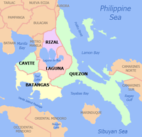
 Map of Rizal with Binangonan highlighted | |
show OpenStreetMap | |
 Binangonan Location within the Philippines | |
| Coordinates: 14°27′05″N 121°11′31″E / 14.4514°N 121.1919°ECoordinates: 14°27′05″N 121°11′31″E / 14.4514°N 121.1919°E | |
| Country | Philippines |
| Region | Calabarzon |
| Province | Rizal |
| District | 1st district |
| Founded | March 29, 1900 |
| Barangays | 40 (see Barangays) |
| Government | |
| • Type | Sangguniang Bayan |
| • Mayor | Cesar M. Ynares |
| • Vice Mayor | Cecilio M. Ynares |
| • Representative | Michael John R. Duavit |
| • Municipal Council | show
Members |
| • Electorate | 144,523 voters (2019) |
| Area | |
| • Total | 66.34 km2 (25.61 sq mi) |
| Elevation | 21 m (69 ft) |
| Highest elevation | 186 m (610 ft) |
| Lowest elevation | 2 m (7 ft) |
| Population (2020 census) [3] | |
| • Total | 313,631 |
| • Density | 4,700/km2 (12,000/sq mi) |
| • Households | 66,734 |
| Economy | |
| • Income class | 1st municipal income class |
| • Poverty incidence | 6.46% (2015)[4] |
| • Revenue | ₱515,970,251.68 (2016) |
| Service provider | |
| • Electricity | Manila Electric Company (Meralco) |
| Time zone | UTC+8 (PST) |
| ZIP code | 1940 |
| PSGC | |
| IDD : area code | +63 (0)2 |
| Climate type | tropical monsoon climate |
| Native languages | Tagalog |
| Website | www |


Binangonan, officially the Municipality of Binangonan (Tagalog: Bayan ng Binangonan) is a 1st class municipality in the province of Rizal, Philippines. According to the 2020 census, it has a population of 313,631 people. [3]
A thriving fish port and fishing industry is found in Binangonan, having a long coast line facing the Laguna de Bay, including the western part of Talim Island. The plant of Rizal Cement and Grandspan are in Binangonan as well. Their main livelihood are fishing and farming.
With the continuous expansion of Metro Manila, the municipality is now part of Manila's conurbation which reaches Cardona in its easternmost part.
Etymology[]
It is claimed that the binañgonan means “the first town established along the lake”, in reference to a legend that tells of how the towns around Laguna de Baý were named. More likely however is that binañgonan refers to a place from where someone or something rose, based on the definition of binangunan in Tagalog. The name of the town in the colonial era (as of 18th c.) was "Binangonan de los Ferros" (Binangonan of the Dogs),[5] that etymology might have something to do with dog breeding or hunting.
History[]
The Neolithic stone engravings of the Angono Petroglyphs archaeological site represent the earliest evidence of human settlement in the region. The site contains earthenware fragments and remains of animals such as turtles and Elephas sp.[6] The area was inhabited by both Tagalog and Aeta peoples before the arrival of the Spanish.[7]
Spanish Period[]
Binangonan was initially a visita of the pueblo (town) of Moron,[8] until it was separated and became an independent parish in 1621 through the initiatives of Franciscan missionaries. The town was established in 1737 and conquered by the Spaniards in 1763. Originally, it was organized under the province of La Laguna, until it was transferred to the newly established Distrito de Morong on 23 February 1853.[8] The Santa Ursula Parish Church dates from this time, built from 1792 to 1800. It became a town in 1900 during the American colonial period.
Japanese occupation[7][]
During World War II, Binangonan was one of the evacuation centers for the residents of Manila and neighboring suburbs. People hid in the mountains and in Talim Island. The war brought untold difficulties and sufferings. Schools were temporarily closed; professionals turned to fishing, buy and sell for living. Many died of starvation, malnutrition and diseases while others survived by eating camote tops, papaya, corn, coconut and vegetables.
Months after the Japanese occupied the town, Faustino Antiporda organized Bantay Sunog, a brigade tasked in maintaining peace and order by providing volunteer males as nightly guards against looters and trouble makers.
In April 1942, Marcos Villa Agustin founded Marking's Guerrillas, and recruited heavily in Binangonan area. During the summer of 1942, the Rizal Cement Factory employees took action against the Japanese in the area. Led by Trinidad Diaz, the factory cashier and Home Guard lieutenant, they killed five Japanese, including a naval architect, and turned their launch over to Marking's Guerrillas. The Japanese took revenge, killing known resisters in the area, and torturing Diaz for 32 days, but she did not divulge the guerrilla's locations.[9][10]
Major Teofilo Cenido was appointed mayor of the provost marshal of military police. Weapons available then were one Springfield Rifle and five Granadora from five USAFFE soldiers who escaped from Bataan.
Talim Island was also subjected to Japanese sona. On August 7, 1942, bombs were dropped in the neighboring towns killing four in Janosa and claiming a number of casualties in Cardona. Suspected guerillas were brought to Santa Cruz, Laguna. Even the parish priest at that time, a Columbian Fr. Martin Strong, was held in Los Baños concentration camp.
Late in 1944, the Makapilis identified mostly as Kapampangan's, a group of pro-Japanese Filipinos, occupied the convent and served as Japanese interpreters. They were instruments in the cruelties suffered by the Filipinos.
In January 1945, the Japanese took the convent from the Makapilis and put up their headquarters. But they only stayed there for one week, scared of the nightly apparitions of a white lady believed to be the ghost haunting the convent.
Mayor Emerenciano Unida was killed by the Japanese when he refused to reveal the guerrilla organization.
Period of independence[7][]
Binangonan was liberated from the Japanese forces on February 25, 1945, the feast day of the patroness of the town, Santa Ursula. The Japanese' plan to burn the town was prevented by the timely arrival of American forces on the eve of the feast day. The local guerillas, with Major Ceñido deploying his men in Bunot Mountain, prevented the escape of Japanese forces. The Japanese peacefully retreated and pulled their forces out.
The liberation was quite peaceful for no fighting ever took place. It was also a glorious celebration as barrio folks rode on top of tanks and jeepneys with the soldiers of the combined Filipinos and Americans. People lined along the streets, jumping with glee, weeping tears of joy while shouting "Victory". The American and Filipino military commander instructed the guerillas led by Major Ceñido to set up temporary headquarters in poblacion and to do surveillance work. When the combined Filipino and American troops proceeded to Angono, they left the command under the local Military Police, composed of all units in Binangonan.
Napoleon Antazo, the town commander of the Hunters ROTC guerillas, was appointed mayor through the orders of the 43rd Infantry Division of the U.S. Army. Next to be appointed town mayor from 1945 to 1946 was Casimiro Ynares Sr., son of Don Jose Ynares. When the Philippines became a Republic in 1946, the municipal government was allowed greater autonomy.
Post-war accomplishments 1946-1951[]
The first mayor after World War II was Dr. Jose Pacis. Among his accomplishments were as follows.
- Construction of wharf linking the Muella de Santa Ursula to Pritil.
- Construction of a modern public market, a self-liquidating project funded by the Rehabilitation Finance Corporation.
- Construction of combined basketball courts and tennis courts in the town's plaza.
- Beautification of the Kalbaryo.
- Additional artesian wells.
- Construction of a new street extending from Munting Bundok to M. H. del Pilar Street, the only one in eastern Rizal at that time, which was completed with the P25,000.00 funds donated by ex-Senator Vicente Madrigal to Mayor Jose Pacis.
Cityhood[]
As early as January 18, 2016, the town's Sangguniang Bayan approved Resolution No. 78, Series of 2016 requesting the Senate of the Philippines thru its president Franklin Drilon and the House of Representatives thru its speaker Feliciano Belmonte Jr. to co-sponsor a bill for Binangonan's conversion into a city and creation of a lone legislative district.
Geography[]
Binangonan is bounded to the north-northwest by Angono, the north-northeast by Teresa and Morong, and to the east by Cardona. It is divided between two regions, the mainland and the insular areas. The mainland is on the western side of the Morong Peninsula, and is characterized by small steep hills surrounded by lowlands. It is cut off by an escarpment to the east, which forms the boundary with Cardona. Short streams predominantly drain westward into Laguna de Bay.
Talim Island contains a narrow coastal plain that readily ascends into its mountainous interior, with Mount Tagapo (438 m) as its highest peak. It is separated from the mainland by the 240-m Diablo pass.
Climate[]
Binangonan features two climate types under the Köppen-Geiger climate classification: tropical monsoon with a short dry season and a prolonged wet season, and tropical savanna with more pronounced wet and dry season. The dry season runs from January through April while the wet season covers the remaining eight months of the year. Binangonan is consistently hot throughout the year, usually reaching its highest temperatures just before the onset of the monsoon. The town's coolest temperatures are typically experienced at night during the earliest portions of the dry season. Temperatures are relatively constant throughout the year with the average high of about 31 °C (88 °F) and an average low of about 23 °C (73 °F).
| hideClimate data for Binangonan, Rizal | |||||||||||||
|---|---|---|---|---|---|---|---|---|---|---|---|---|---|
| Month | Jan | Feb | Mar | Apr | May | Jun | Jul | Aug | Sep | Oct | Nov | Dec | Year |
| Average high °C (°F) | 26 (79) |
27 (81) |
29 (84) |
31 (88) |
31 (88) |
30 (86) |
29 (84) |
29 (84) |
29 (84) |
29 (84) |
28 (82) |
26 (79) |
29 (84) |
| Average low °C (°F) | 22 (72) |
22 (72) |
22 (72) |
23 (73) |
24 (75) |
25 (77) |
24 (75) |
24 (75) |
24 (75) |
24 (75) |
24 (75) |
23 (73) |
23 (74) |
| Average precipitation mm (inches) | 58 (2.3) |
41 (1.6) |
32 (1.3) |
29 (1.1) |
91 (3.6) |
143 (5.6) |
181 (7.1) |
162 (6.4) |
172 (6.8) |
164 (6.5) |
113 (4.4) |
121 (4.8) |
1,307 (51.5) |
| Average rainy days | 13.4 | 9.3 | 9.1 | 9.8 | 19.1 | 22.9 | 26.6 | 24.9 | 25.0 | 21.4 | 16.5 | 16.5 | 214.5 |
| Source: Meteoblue [11] | |||||||||||||
Barangays[]

Binangonan is politically subdivided into 40 barangays, [12] of which 23 are on the mainland and 17 are island barangays.
| Barangay | Location | Population | Land Area[7] | Density (2020) | ||
|---|---|---|---|---|---|---|
| (2020)[13] | (2015)[14] | (2010)[15] | ||||
| Bangad | Island | 1,478 | 1,563 | 1,505 | 1.10 | 1,343.64 |
| Batingan | Mainland | 16,280 | 13,931 | 12,999 | 1.10 | 14,800.00 |
| Bilibiran | Mainland | 18,577 | 16,905 | 15,490 | 2.47 | 7,521.05 |
| Binitagan | Island | 572 | 598 | 680 | 0.42 | 1,361.90 |
| Bombong | Island | 3,275 | 3,256 | 2,697 | 0.99 | 3,308.08 |
| Buhangin | Island | 2,000 | 1,871 | 2,086 | 1.10 | 1,818.18 |
| Calumpang | Mainland | 19,092 | 18,596 | 15,793 | 1.59 | 12,007.55 |
| Ginoong Sanay | Island | 1,745 | 1,638 | 1,588 | 0.88 | 1,982.95 |
| Gulod | Island | 1,216 | 1,197 | 1,184 | 0.71 | 1,712.68 |
| Habagatan | Island | 1,397 | 1,275 | 1,587 | 0.66 | 2,116.67 |
| Ithan | Mainland | 3,757 | 3,090 | 2,907 | 1.02 | 3,683.33 |
| Janosa | Island | 3,087 | 2,917 | 2,606 | 1.74 | 1,774.14 |
| Kalawaan (Darangan) | Mainland | 39,677 | 36,853 | 28,611 | 4.63 | 8,569.55 |
| Kalinawan | Mainland | 2,106 | 2,062 | 2,023 | 0.65 | 3,240.00 |
| Kasile | Island | 470 | 475 | 502 | 0.31 | 1,516.13 |
| Kaytome | Island | 2,403 | 2,296 | 2,241 | 0.79 | 3,041.77 |
| Kinaboogan | Island | 1,267 | 1,370 | 1,164 | 1.14 | 1,111.40 |
| Kinagatan | Island | 1,470 | 1,466 | 1,442 | 0.55 | 2,672.73 |
| Layunan (Poblacion) | Mainland | 2,575 | 2,491 | 3,370 | 2.54 | 1,013.78 |
| Libid (Poblacion) | Mainland | 8,068 | 7,089 | 7,085 | 2.53 | 3,188.93 |
| Libis (Poblacion) | Mainland | 5,905 | 6,738 | 6,668 | 2.35 | 2,512.77 |
| Limbon-limbon | Mainland | 1,702 | 1,590 | 1,457 | 0.31 | 5,490.32 |
| Lunsad | Mainland | 11,748 | 10,800 | 10,375 | 2.53 | 4,643.48 |
| Macamot | Mainland | 10,301 | 9,221 | 8,168 | 2.35 | 4,383.40 |
| Mahabang Parang | Mainland | 11,052 | 8,935 | 7,228 | 3.13 | 3,530.99 |
| Malakaban | Island | 1,149 | 1,216 | 1,197 | 1.04 | 1,104.81 |
| Mambog | Mainland | 11,372 | 9,988 | 7,614 | 1.33 | 8,550.38 |
| Pag-asa | Mainland | 19,476 | 16,848 | 15,392 | 0.89 | 21,883.15 |
| Palangoy | Mainland | 17,865 | 14,038 | 13,505 | 4.71 | 3,792.99 |
| Pantok | Mainland | 16,800 | 15,116 | 13,110 | 3.96 | 4,242.42 |
| Pila-Pila | Mainland | 9,437 | 9,190 | 8,247 | 2.79 | 3,382.44 |
| Pinagdilawan | Island | 813 | 778 | 664 | 0.33 | 2,463.64 |
| Pipindan | Mainland | 1,928 | 2,429 | 2,841 | 0.50 | 3,856.00 |
| Rayap | Island | 2,164 | 2,001 | 1,886 | 0.79 | 2,739.24 |
| San Carlos | Mainland | 14,090 | 11,983 | 10,428 | 1.13 | 12,469.03 |
| Sapang | Island | 2,249 | 2,265 | 2,050 | 1.12 | 2,008.04 |
| Tabon | Island | 617 | 823 | 834 | 0.81 | 761.73 |
| Tagpos | Mainland | 15,999 | 15,560 | 12,332 | 1.31 | 12,212.98 |
| Tatala | Mainland | 16,152 | 10,773 | 7,256 | 3.56 | 4,537.08 |
| Tayuman | Mainland | 12,300 | 11,243 | 10,825 | 5.19 | 2,369.94 |
| Mainland | 286,259 | 255,469 | 223,724 | 52.55 | 5,447.36 | |
| Island | 27,372 | 27,005 | 25,913 | 14.46 | 1,892.95 | |
| Total | 40 barangays | 313,631 | 282,474 | 249,637 | 67.02 | 4,680.36 |
Demographics[]
| Year | Pop. | ±% p.a. |
|---|---|---|
| 1903 | 9,096 | — |
| 1918 | 14,379 | +3.10% |
| 1939 | 16,588 | +0.68% |
| 1948 | 20,422 | +2.34% |
| 1960 | 31,274 | +3.61% |
| 1970 | 52,296 | +5.27% |
| 1975 | 63,215 | +3.88% |
| 1980 | 80,980 | +5.08% |
| 1990 | 127,561 | +4.65% |
| 1995 | 140,700 | +1.85% |
| 2000 | 187,691 | +6.37% |
| 2007 | 238,931 | +3.39% |
| 2010 | 249,872 | +1.64% |
| 2015 | 282,474 | +2.36% |
| 2020 | 313,631 | +2.08% |
| Source: Philippine Statistics Authority [16] [17] [18][19] | ||
In the 2020 census, the population of Binangonan, was 313,631 people, [3] with a density of 4,700 inhabitants per square kilometre or 12,000 inhabitants per square mile.
Economy[]


Binangonan's major source of income comes from agriculture, where 49 percent of its total land area are devoted to agriculture and livestock industries, while the source of income of residents in its coastal barangays are mainly artisanal fishing and the aquaculture industry.[7] Binangonan is a major supplier of freshwater fishes from Laguna de Bay like dulong, ayungin, biya, kanduli, and gurami to Metro Manila, Laguna, Cavite and Batangas. A research station of the Southeast Asian Fisheries Development Center is located at Tapao Point in Barangay Pipindan.[26]
The municipality formerly hosted the Rizal Cement plant in Calumpang and its associated quarry. This plant was the oldest in the Philippines, established in 1914 by Augustinians and eventually acquired by Vicente Madrigal.[27] A limestone quarry in Pantok supplied the plant through a cable car system. The plant was shut down in 2000 and subsequently transformed into a subdivision.
Other sources of income come from manufacturing, commercial establishments, real estate, and public utility services.
Binangonan's economy remained docile for almost four decades, subsisting only with fair performance in the aquaculture and agricultural ventures with no new developments in-place to create job opportunities in the commercial sector. Tourism industry's growth remains to be seen in the long-term. Industries relative interests to the town has to be developed and the corresponding infrastructure must be funded and implemented accordingly to create and sustain future development.
Overall expectations to encourage investment must be prioritized rather than enticing the growth of informal settlers (squatters) in the area which was perceived by many to be more of strategic political undertakings.
Tourism[]

Tourist Attractions
- East Ridge Golf and Country Club
- Thunderbird Resorts and Fiesta Casino
- Talim Island
- Mount Tagapo Nature Park
- Vicente Manansala Shrine
- Santa Ursula Parish Church
- Mount Calvary (Kalbaryo)
- Marian Hill
- Tabon
- Binangonan Recreation and Conference Center
- Puente Del Diablo
- Angono-Binangonan Petroglyphs
- The Lighthouse at Santorini Estates
Festival and Traditions
- Caru-Caruhan de Binangonan
- Annual Traditional Ball
- Brgy. Libid Grand Santacruzan
- Binalayan Festival
- Sunduan
- Giwang-Giwang
Government[]

Current Officials[28][]
| Title | Name |
|---|---|
| Mayor | Cesar M. Ynares |
| Vice Mayor | Cecilio M. Ynares |
| Councilor | Fidelito C. Ceñidoza |
| James Michael A. Paralejas | |
| Michael Reynan C. Dela Cuesta | |
| Ma. Cristina E. Cerda | |
| Nicanor C. Del Mundo | |
| Jesus M. Añis | |
| Oscarlito C. Cequeña | |
| Eric J. Vital | |
| Virgilio B. Cerda | |
| Antonio Ma. B. Reyes IV |
List of former mayors[7][]
American period[]
- Jose G. Ynares – (1901–1905) First appointed executive of the municipality in 1901 and elected Presidente the following year.
- Manuel Y. Ison – (1906–1907) He raised funds for the construction of the first municipal building.
- Clemente Antiporda – (1908–1912) During his term, a permanent municipal building was constructed.
- Antonio Sisante – (1913–1915) His achievement was the construction of three artesian wells.
- Lorenzo Flores – (1916–1922) Roads and bridges were built and the old market was repaired during his term.
- Valentin Antazo – (1922–1928) He purchased the present Binangonan Central Elementary School site; built the H.E. Building and the Puericulture Center for the Women's Club.
- Julio Antiporda – (1928–1936) He planned the establishment of a public market in Pila-pila.
Japanese period[]
- Felix Katipunan -- (1936–1942) He built roads and artesian wells and added rooms to the municipal building.
- Emerenciano M. Unida -- (1942–1945) He was the deputy mayor when Katipunan got ill. He supplied starving residents with foods and worked for the release of captured Filipinos.
- Juan Jerusalem - (1945) Took over aster the death of Unida until his shooting.
Post-war to present[]
- Napoleon Antazo (1945) - Appointed by the U.S. Army 43rd Infantry Division
- Casimiro Ynares, Sr. (1945-1946) - Appointed
- Jose Pacis (1946-1951) Elected after resumption of election following Philippine independence in 1946. Presided over many construction efforts, including roads, wharves and the public market.
- Casimiro Ynares Sr. - (1952-1956)
- Jose Pacis - (1957-1962)
- Pedro Fineza - (1963-1970)
- Casimiro Ynares, Jr. - (1971-1986) Due to the declaration of Martial Law by President Ferdinand Marcos, he remained as mayor owing to the lack of elections. He was deposed following the 1986 People Power Revolution.
- Mariano Cervo - (1986-1988) Officer-in-charge following the revolution.
- Casimiro Ynares, Jr. (1988-1992)
- Isidro B. Pacis - (1992-1998)
- Cesar M. Ynares - (1998-2007)
- Cecilio M. Ynares - (2007-2016)
- Cesar M. Ynares - (2016–present)
Health institutions[]
- Binangonan Municipal Community Health Center, Libis
- Binangonan Lakeview Hospital, Tagpos
- Pag-asa Hospital, Pag-asa
- Margarito A. Duavit Memorial Hospital - Rizal Provincial Hospital System, Binangonan (Annex)
- St. Bernard Infirmary and Multi-Specialty Clinic, Pantok
Barangay Health Centers are present in all 40 barangays[7]
Education[]
The Department of Education operates 36 elementary and 9 secondary schools in the municipality. A campus of the University of Rizal System is present. A Technical Education Skills Development Authority (TESDA) center established in the municipality provides technical and vocational courses. Over 50 private schools are also found within the municipality,[7]
Public[]
Tertiary
Secondary
- Rizal National Science High School
- Vicente Madrigal National High School
- Guronasyon Foundation Inc. National High School
- Don Jose M. Ynares Sr. Memorial National High School
- Margarito A. Duavit Memorial National High School
- Janosa National High School
- Talim National High School
- Pag-asa National High School
Elementary
DISTRICT I
- Binangonan Elementary School
- Calumpang Elementary School
- Darangan Elementary School
- Mahabang Parang Elementary School
- Libis Elementary School
- Libid Elementary School
- Macamot Elementary School
- Tatala Elementary School
- Casimiro Ynares Elementary School
- Pila-Pila Elementary School
DISTRICT II
- Lunsad Elementary School
- Limbon-Limbon Elementary School
- Ithan Elementary School
- Kalinawan Elementary School
- Pipindan Elementary School
- Kasile Elementary School
- Bombong Elementary School
- Kinagatan Elementary School
- Kinaboogan Elementary School
- Bangad Elementary School
- Buhangin Elementary School
- Janosa Elementary School
- Kaytome/Gulod Elementary School
- Sapang Elementary School
- Malakaban Elementary School
- Pinagdilawan Elementary School
- Tabon Elementary School
- Talim Elementary School
- Banaba(Rayap) Elementary School
DISTRICT III
- Tayuman Elementary School
- Tagpos Elementary School
- Pag-asa Elementary School
- Doña Susana Memorial Elementary School
- Bilibiran Elementary School
- Mabuhay Homes Elementary School
- Don Jose Ynares Sr. Elementary School
- Sitio Mata Elementary School
Private[]
Tertiary
- ICCT Colleges
- PBTS Academy
Secondary
- Southwell School
- Genesis De Rizal School
- Tres Niños School Inc
- Bilibiran Christian School
- Child Jesus Prague School
- Child's Place Developmentally Appropriate Program School
Elementary
- Right Step School of Learning
- Child's Place D.A.P School Inc.
- Bilibiran Christian School Inc.
- Palm Mary Private School.
- Little Children of Isaac
- SMA Lerning School(Pantok)
- SMA Lerning School(San Carlos)
- Binangonan Catholic College
- Child Jesus of Prague School Inc.
- Tres Ninos Learning Center Macee Academy
- Gain Knowledge Learning Center
- Shining Light Christian Academy
- Binangonan Garden of Learners
- Sanlex Divine Grace Academy
- PBTS Academy(Macamot)
- PBTS Academy(Pantok)
- PBTS Academy(Bilibiran)
- PBTS Academy(Tagpos)
- Niña Maria Learning Center
- Southwell School
- Raises Montessori Academy(Calumpang)
- Raises Montessori Academy(Pantok)
- Raises Montessori Academy(Pag-asa)
- Claremont School.
- Zion Hills Christian Academy Inc.
- Knights & Archers Montessori
- Children's Brighter Educ.Learning
- Throne of Wisdom Christian Academy
- Remi Andrea School
- Sunnyvale Christian School
- Early Bird Learning Academy Inc.
- Maries Christian School
- Optimus Center for Development(Bilibiran)
- Optimus Center for Development(Tayuman)
- Angono Spring Academy School Inc.
- Bridge of Light Grace Christian Academy Inc.
- Growth for Knowledge Learning Center Inc.
Cultural properties[]
| Cultural Property wmph identifier |
Site name | Description | Province | City/municipality | Address | Coordinates | Image |
|---|---|---|---|---|---|---|---|
| Santa Ursula Parish Church | Rizal | Binangonan, Rizal |  | ||||
| Alvarez Clinic | Walls of the structure came from the stones used to build Santa Ursula Church. | Rizal | Binangonan, Rizal |  | |||
| Oldest Bakery in Binangonan | Has the oldest pugon dated 1960's and is still being used | Rizal | Binangonan, Rizal | 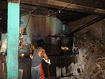 |
- Gloc-9, rap artist, musician, songwriter
References[]
- ^ Municipality of Binangonan | (DILG)
- ^ "2015 Census of Population, Report No. 3 – Population, Land Area, and Population Density" (PDF). Philippine Statistics Authority. Quezon City, Philippines. August 2016. ISSN 0117-1453. Archived (PDF) from the original on May 25, 2021. Retrieved July 16, 2021.
- ^ Jump up to: a b c Census of Population (2020). "Region IV-A (Calabarzon)". Total Population by Province, City, Municipality and Barangay. PSA. Retrieved 8 July 2021.
- ^ https://psa.gov.ph/sites/default/files/City%20and%20Municipal-level%20Small%20Area%20Poverty%20Estimates_%202009%2C%202012%20and%202015_0.xlsx; publication date: 10 July 2019; publisher: Philippine Statistics Authority.
- ^ Blair, Emma (1906). The Philippine Islands, 1493-1898 Vol. 40. Arthur H. Clark Company. p. 142url=http://mirrors.aggregate.org/gutenberg/2/5/9/3/25930/25930-h/25930-h.htm#app.5.
- ^ "Angono Petroglyphs". National Museum of the Philippines. Retrieved 15 August 2019.
- ^ Jump up to: a b c d e f g h "Socio-Economic Profile of the Municipality of Binangonan" (PDF). Binangonan Municipal Government.
- ^ Jump up to: a b Pascual, Timoteo; Guillermo, Liwayway (1978). Morong's 400 Years. University of Santo Tomas Press.
- ^ Kaminski, Theresa (2016). Angels of the Underground. New York: Oxford University Press. pp. 239–240, 243. ISBN 9780199928248.
- ^ Panlilio, Yay (1950). The Crucible: An Autobiography by Colonel Yay, Filipina American Guerrilla. New Brunswick: Rutgers University Press. pp. 30-32. ISBN 9780813546827.
- ^ "Binangonan: Average Temperatures and Rainfall". Meteoblue. Retrieved 11 May 2020.
- ^ "Province: Rizal". PSGC Interactive. Quezon City, Philippines: Philippine Statistics Authority. Retrieved 12 November 2016.
- ^ "2020 Census of Population and Housing (2020 CPH) Population Counts Declared Official by the President". Philippine Statistics Authority. July 7, 2021.
- ^ Census of Population (2015). "Region IV-A (Calabarzon)". Total Population by Province, City, Municipality and Barangay. PSA. Retrieved 16 August 2019
- ^ Census of Population and Housing (2010). "Region IV-A (Calabarzon)". Total Population by Province, City, Municipality and Barangay. NSO. Retrieved 16 August 2019.
- ^ Census of Population (2015). "Region IV-A (Calabarzon)". Total Population by Province, City, Municipality and Barangay. PSA. Retrieved 20 June 2016.
- ^ Census of Population and Housing (2010). "Region IV-A (Calabarzon)". Total Population by Province, City, Municipality and Barangay. NSO. Retrieved 29 June 2016.
- ^ Censuses of Population (1903–2007). "Region IV-A (Calabarzon)". Table 1. Population Enumerated in Various Censuses by Province/Highly Urbanized City: 1903 to 2007. NSO.
- ^ "Province of Rizal". Municipality Population Data. Local Water Utilities Administration Research Division. Retrieved 17 December 2016.
- ^ "Poverty incidence (PI):". Philippine Statistics Authority. Retrieved 28 December 2020.
- ^ https://psa.gov.ph/sites/default/files/NSCB_LocalPovertyPhilippines_0.pdf; publication date: 29 November 2005; publisher: Philippine Statistics Authority.
- ^ https://psa.gov.ph/sites/default/files/2003%20SAE%20of%20poverty%20%28Full%20Report%29_1.pdf; publication date: 23 March 2009; publisher: Philippine Statistics Authority.
- ^ https://psa.gov.ph/sites/default/files/2006%20and%202009%20City%20and%20Municipal%20Level%20Poverty%20Estimates_0_1.pdf; publication date: 3 August 2012; publisher: Philippine Statistics Authority.
- ^ https://psa.gov.ph/sites/default/files/2012%20Municipal%20and%20City%20Level%20Poverty%20Estima7tes%20Publication%20%281%29.pdf; publication date: 31 May 2016; publisher: Philippine Statistics Authority.
- ^ https://psa.gov.ph/sites/default/files/City%20and%20Municipal-level%20Small%20Area%20Poverty%20Estimates_%202009%2C%202012%20and%202015_0.xlsx; publication date: 10 July 2019; publisher: Philippine Statistics Authority.
- ^ rossea.ledesma. "Binangonan Freshwater Station". SEAFDEC/AQD. Retrieved 2019-08-15.
- ^ "Cement History | Cement Manufacturers' Association of the Philippines". 2016-07-25. Archived from the original on 2016-07-25. Retrieved 2019-08-18.
- ^ "Municipality of Binangonan - Government". www.binangonan.gov.ph. Retrieved 2019-08-18.
External links[]
| Wikimedia Commons has media related to Binangonan. |
- Official website
- Binangonan Profile at PhilAtlas.com
- Taga-Binangonan Ako!
- Binangonan Rizal
- Philippine Standard Geographic Code
- Philippine Census Information
- Local Governance Performance Management System
| show Places adjacent to Binangonan |
|---|
| show Articles Related to Binangonan, Rizal |
|---|

| Authority control |
|---|
- Municipalities of Rizal
- Populated places on Laguna de Bay