Charlotte metropolitan area
Charlotte metropolitan area | |
|---|---|
Metropolitan area | |
| Charlotte–Concord–Gastonia, NC-SC MSA | |
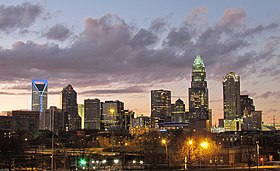 Uptown Charlotte Skyline | |
 Counties most commonly associated with Metrolina are in dark red, counties often included are light red, and counties sometimes included are in orange. The NC/SC state line is shown in yellow. | |
| Country | |
| States | |
| Core city | |
| Principal cities | - Concord - Gastonia - Rock Hill |
| Area | |
| • Metropolitan area | 3,198 sq mi (8,280 km2) |
| • Land | 3,149 sq mi (8,160 km2) |
| • Water | 49 sq mi (130 km2) |
| Elevation | 305–2,560 ft (93–780 m) |
| Population (2019 US Census Bureau estimate) | |
| • Metro | 2,636,883 |
| • Metro density | 825/sq mi (319/km2) |
| • CSA | 2,797,636 |
| Time zone | EST |
| • Summer (DST) | EDT |
| Zip Codes | 280xx,281xx,282xx,286xx,297xx |
| Area code(s) | 704,803,828,980 |
The Charlotte metropolitan area or Metrolina is a metropolitan area of North and South Carolina within and surrounding the city of Charlotte. The metropolitan area also includes the cities of Gastonia, Concord, Huntersville, and Rock Hill as well as the large suburban area in the counties surrounding Mecklenburg County, which is at the center of the metro area. Located in the Piedmont, it is the largest metropolitan area in the Carolinas, and the fourth largest in the Southeastern United States. The Charlotte metropolitan area is one of the fastest growing metropolitan areas in the United States.[1]
There are two official metropolitan boundaries for the Charlotte metropolitan area: the Charlotte-Concord-Gastonia Metropolitan Statistical Area (MSA)[2] and the Charlotte-Concord Combined Statistical Area (CSA).[3] The two regions are identical except for the addition of two micropolitan areas, Shelby and Albemarle to the Charlotte-Concord CSA that are not included in the Charlotte-Concord-Gastonia MSA. The population of the MSA was 2,636,883 and the population of the CSA was 2,797,636 as of 2019 Census estimates.[4] The metropolitan area is slightly larger than 3,000 square miles (7,800 km2).
The Charlotte metro area is a global financial center, transportation hub, and entertainment destination. Charlotte is the second largest financial hub in the United States behind New York City, being the headquarters for Bank of America and Truist Financial as well as housing the East Coast headquarters and largest employment hub of Wells Fargo. Other Fortune 500 companies headquartered in the metro area include Brighthouse Financial, Duke Energy, Honeywell, Lowe's, and Nucor. The Charlotte metro area is the largest manufacturing region in the Carolinas. The estimated gross metropolitan product (GMP) of the metro area is over $170 billion.[5] Located in Mecklenburg County, Charlotte Douglas International Airport is the sixth-largest airport in the world by aircraft movements and the city's location at the junction of I-85 and I-77 makes it a highway logistics center. The Charlotte metro is also the center of American auto racing and is home to the Carolina Panthers, Charlotte Hornets, and Charlotte FC.
The Charlotte metro is home to a number of prominent higher education institutions, including the University of North Carolina at Charlotte, Queens University of Charlotte, Davidson College, Belmont Abbey College, and many more. The primary community college for the area is Central Piedmont Community College, which has several campuses throughout Charlotte and the surrounding region.
Nicknames and regional identity[]
The regional area around the city was at one time called Metrolina, a portmanteau of Metropolis and Carolina. The term has fallen out of widespread general use, though it still maintains a presence and is used by the North Carolina Department of Transportation. The term does retain a marketing value, and is thus also used by many businesses in the area. Metrolina refers to the region that includes the cities of Charlotte, Concord, Gastonia and Rock Hill. The name Metrolina came into fashion when North Carolina's other two large metropolitan areas took on nicknames—the Triangle for Raleigh/Durham/Cary/Chapel Hill and the Triad for Greensboro/Winston-Salem/High Point. (The Triad now goes by the name Piedmont Triad to distinguish it from other tri-cities.)
Charlotte's most common nickname is the Queen City, often abbreviated as Q.C., a name derived from the city's namesake, Queen Charlotte of Mecklenburg-Strelitz.
The term "Charlotte USA" referred to the 16-county region, which includes 12 counties in North Carolina and 4 counties in South Carolina. The term was championed during a marketing campaign by the Charlotte Regional Partnership, a non-profit organization made up of both private- and public-sector members from throughout the Charlotte region. This organization represents one of seven officially designated economic development regions in North Carolina.[6]
Region J of the North Carolina Councils of Government, of which a majority of the Charlotte area municipalities and counties belong, uses the term Centralina in its body's name, Centralina Council of Governments. This term, however, is used only sparingly among locals.
Geography[]
| Historical populations | |||
|---|---|---|---|
| Census | Pop. | %± | |
| 1900 | 55,268 | — | |
| 1910 | 67,031 | 21.3% | |
| 1920 | 80,695 | 20.4% | |
| 1930 | 127,971 | 58.6% | |
| 1940 | 151,826 | 18.6% | |
| 1950 | 197,052 | 29.8% | |
| 1960 | 615,714 | 212.5% | |
| 1970 | 741,118 | 20.4% | |
| 1980 | 855,482 | 15.4% | |
| 1990 | 1,024,643 | 19.8% | |
| 2000 | 1,330,448 | 29.8% | |
| 2010 | 2,217,012 | 66.6% | |
| 2020 | 2,660,329 | 20.0% | |
| U.S. Decennial Census[7] 1790–1960[8] 1900–1990[9] 1990–2000[10] | |||
Counties[]
The official Charlotte metropolitan area includes the Charlotte–Concord–Gastonia MSA (Anson, Cabarrus, Gaston, Iredell, Lincoln, Mecklenburg, Rowan, and Union counties in North Carolina; Chester, Lancaster and York counties in South Carolina). The Charlotte CSA includes all the MSA counties along with the following micropolitan areas in North Carolina: Albemarle (Stanly County) and Shelby (Cleveland County). (Census Bureau definition for CSA)[11]
The Charlotte Regional Partnership also identifies three additional counties to the what they refer to as the 'Charlotte Region'-Alexander and Catawba counties in North Carolina, and Chesterfield County, South Carolina. Catawba and Alexander counties are currently part of the Hickory–Lenoir–Morganton Metropolitan Statistical Area or 'The Unifour'. Factoring in the Unifour, as well as Chesterfield County, if one considers these regions to be part of the Charlotte area, as many in the area regard them as such, the population according to 2018 Census estimates, increases to 3,190,390. If this population was officially used, the Charlotte Area would become the 20th largest CSA, overtaking the St. Louis, Missouri area, and placing it behind Portland, Oregon.
| County | 2020 Census | 2010 Census | Change |
|---|---|---|---|
| Mecklenburg County | 1,115,482 | 919,628 | +21.30% |
| York County | 282,090 | 226,073 | +24.78% |
| Union County | 238,267 | 201,292 | +18.37% |
| Gaston County | 227,943 | 206,086 | +10.61% |
| Cabarrus County | 225,804 | 178,011 | +26.85% |
| Iredell County | 186,693 | 159,437 | +17.10% |
| Rowan County | 146,875 | 138,428 | +6.10% |
| Cleveland County | 99,519 | 98,078 | +1.47% |
| Lancaster County | 96,016 | 76,652 | +25.26% |
| Lincoln County | 86,810 | 78,256 | +10.93% |
| Stanly County | 62,504 | 60,585 | +3.17% |
| Chester County | 32,294 | 33,140 | −2.55% |
| Anson County | 22,055 | 26,948 | −18.16% |
| Total | 2,822,352 | 2,402,614 | +17.47% |
| County | 2020 Estimate | 2010 Census | Change |
|---|---|---|---|
| Catawba County | 160,610 | 154,358 | +4.05% |
| Chesterfield County | 43,273 | 46,734 | −7.41% |
| Alexander County | 36,444 | 37,198 | −2.03% |
| Total for Alexander, Catawba, and Chesterfield counties | 240,327 | 238,290 | +0.85% |
| Total for entire Charlotte region | 3,062,679 | 2,641,534 | +15.94% |
Largest cities and towns[]
| Rank | City / town | County | 2020 Census | 2010 Census | Change |
|---|---|---|---|---|---|
| 1 | Charlotte | Mecklenburg County | 874,579 | 731,424 | +19.57% |
| 2 | Concord | Cabarrus County | 105,240 | 79,066 | +33.10% |
| 3 | Gastonia | Gaston County | 80,411 | 71,741 | +12.09% |
| 4 | Rock Hill | York County | 74,372 | 66,154 | +12.42% |
| 5 | Huntersville | Mecklenburg County | 61,376 | 46,773 | +31.22% |
| 6 | Kannapolis | Cabarrus County / Rowan County | 53,114 | 42,625 | +24.61% |
| 7 | Mooresville | Iredell County | 50,193 | 32,711 | +53.44% |
| 8 | Indian Trail | Union County | 39,997 | 33,518 | +19.33% |
| 9 | Salisbury | Rowan County | 35,540 | 33,662 | +5.58% |
| 10 | Monroe | Union County | 34,562 | 32,797 | +5.38% |
| 11 | Cornelius | Mecklenburg County | 31,412 | 24,866 | +26.33% |
| 12 | Matthews | Mecklenburg County / Union County | 29,435 | 27,198 | +8.22% |
| 13 | Statesville | Iredell County | 28,419 | 24,532 | +15.84% |
| 14 | Mint Hill | Mecklenburg County / Union County | 26,450 | 22,722 | +16.41% |
| 15 | Fort Mill | York County | 24,521 | 10,811 | +126.82% |
| 16 | Shelby | Cleveland County | 21,918 | 20,323 | +7.85% |
| 17 | Waxhaw | Union County | 20,534 | 9,859 | +108.28% |
| 18 | Harrisburg | Cabarrus County | 18,967 | 11,526 | +64.56% |
| 19 | Mount Holly | Gaston County | 17,703 | 13,656 | +29.64% |
| 20 | Albemarle | Stanly County | 16,432 | 15,903 | +3.33% |
| 21 | Stallings | Union County/ Mecklenburg County | 16,112 | 13,831 | +16.49% |
| 22 | Davidson | Mecklenburg County / Iredell County | 15,106 | 10,944 | +38.03% |
| 23 | Belmont | Gaston County | 15,010 | 10,076 | +48.97% |
| 24 | Weddington | Mecklenburg County / Union County | 13,181 | 9,459 | +39.35% |
| 25 | Tega Cay | York County | 12,832 | 7,620 | +68.40% |
| 26 | Kings Mountain | Cleveland County / Gaston County | 11,142 | 10,296 | +8.22% |
| 27 | Lincolnton | Lincoln County | 11,091 | 10,486 | +5.77% |
| 28 | Pineville | Mecklenburg County | 10,602 | 7,479 | +41.76% |
Cities and Towns: 5,000 to 10,000 in Population[]
| Rank | City / Town | County | 2020 Estimate | 2010 Census | Change |
|---|---|---|---|---|---|
| 1 | Wesley Chapel | Union County | 8,681 | 7,463 | +16.32% |
| 2 | York | York County | 8,503 | 7,736 | +9.91% |
| 3 | Lancaster | Lancaster County | 8,460 | 8,526 | −0.77% |
| 4 | Clover | York County | 6,671 | 5,094 | +30.96% |
| 5 | Unionville | Union County | 6,643 | 5,929 | +12.04% |
| 6 | Marvin | Union County | 6,358 | 5,579 | +13.96% |
| 7 | Cherryville | Gaston County | 6,078 | 5,760 | +5.52% |
| 8 | Dallas | Gaston County | 5,927 | 4,488 | +32.06% |
| 9 | Bessemer City | Gaston County | 5,428 | 5,340 | +1.65% |
| 10 | Cramerton | Gaston County | 5,296 | 4,165 | +27.15% |
| 11 | Chester | Chester County | 5,269 | 5,607 | −6.03% |
| 12 | Wadesboro | Anson County | 5,008 | 5,813 | −13.85% |
Suburban towns and cities under 5,000 in population[]
|
|
|
Unincorporated communities[]
|
|
|
|
Changes in house prices for the area are publicly tracked on a regular basis using the Case–Shiller index; the statistic is published by Standard & Poor's and is also a component of the S&P 20-city composite index of the value of the U.S. residential real estate market.
Transportation[]
Mass transit[]
The Charlotte Area Transit System (CATS) is the mass transit agency that operates local, express, bus rapid services that serves Charlotte and its immediate suburban communities in both North and South Carolina. CATS also operates light rail and streetcar lines. CATS is also building a commuter, light rail, streetcar network as a supplement to its established bus transit throughout the region. The LYNX Blue Line runs from Interstate 485, through SouthEnd, Uptown Charlotte, to the University of North Carolina at Charlotte. Plans are for it to stretch initially to Mooresville, Pineville, and Matthews. Charlotte-Douglas International Airport will be connected to the system by light rail.
Roads[]
The Charlotte region is also served by 2 major interstate highways (I-85 and I-77), and their 2 spurs (I-277, and I-485). I-40 also passes through the center of Iredell County, which is the northern region of the Charlotte metro. Other major freeways include Independence Boulevard (east Charlotte to I-277), a portion of US 321 between Hickory and Gastonia, and Monroe Connector / Bypass, each projected to cost over $1 billion per project.
Other important US highways in the region include: US 74 (east to Wilmington, west to Asheville and Chattanooga), US 52 (through the far eastern part of the region), US 321 (through Chester, York, Gastonia, Dallas, Lincolnton and Hickory), US 601 (passing east of Charlotte) and US 70 (through Salisbury, Statesville and Hickory).
Primary state routes include NC/SC 49, NC 16 (which extends north to West Virginia), NC 73, NC 150, NC 18, NC 24, NC 27, SC 9 and SC 5.
Air[]
Charlotte Douglas International Airport is the main airport in the Charlotte area and the 6th busiest in the country. In April 2007, Charlotte was the fastest growing airport in the US.[12] The airport went on to surpass its sister US Airways hub in Philadelphia, Pennsylvania as one of the 30 busiest airports in the world in terms of passenger traffic.[citation needed] A new terminal to the northwest of the center of the airport will be built in the near future, possibly as a Caribbean/Latin America international terminal. CLT is also supplemented by regional airports in Concord, Gastonia, Hickory, Monroe, Statesville, in North Carolina, as well as Rock Hill in South Carolina.
Higher education[]
Four-year institutions[]
- North Carolina
|
|
- South Carolina
- Clinton College
- Winthrop University
- University of South Carolina-Lancaster
Two-year institutions[]
- North Carolina
|
|
- South Carolina
- York Technical College
Defunct institutions[]
- Charlotte School of Law (2006–2017, private for-profit law school)
- King's College (1901–2018, private for-profit two-year college)
Healthcare[]
- Hospitals of the Atrium Health system
- Carolinas Medical Center (Charlotte)
- Levine Children's Hospital (Charlotte)
- Carolinas Medical Center-Mercy (Charlotte)
- Atrium Health Cabarrus (Concord)
- Atrium Health Pineville (Pineville)
- Atrium Health University City (Charlotte)
- Atrium Health Union (Monroe)
- Atrium Health Kings Mountain (Kings Mountain)
- Hospitals of the Novant Health system
- Novant Health Presbyterian Medical Center (Charlotte)
- Novant Health Hemby Children's Hospital (Charlotte)
- Novant Health Rowan Medical Center (Salisbury)
- Novant Health Charlotte Orthopedic Hospital (Charlotte)
- Novant Health Matthews Medical Center (Matthews)
- Novant Health Mint Hill Medical Center (Mint Hill)
- Novant Health Huntersville Medical Center (Huntersville)
- Other hospitals
- CaroMont Regional Medical Center (Gastonia)
- Lake Norman Regional Medical Center (Mooresville)
- Piedmont Medical Center (Rock Hill)
Attractions[]
Nature and geography[]
The foothills of the Blue Ridge Mountains begin along the western edge of the region; the descent (the Fall Line) to the coastal plain begins along the eastern edge. Amid this varied topography, the Daniel Stowe Botanical Garden and several state parks (Morrow Mountain, Crowders Mountain, South Mountains, Duke Power, Landsford Canal, Andrew Jackson) offer recreational possibilities, along with the Uwharrie National Forest just east and northeast of Albemarle, and the Sumter National Forest at the southwest corner of the area. Kings Mountain National Military Park is partially located in York County and in Cherokee County near Blacksburg, South Carolina.
Cultural attractions[]

Attractions in Charlotte include the Harvey B. Gantt Center for African-American Arts + Cultural, Carowinds theme park, Discovery Place, Spirit Square, NASCAR Hall of Fame, the North Carolina Blumenthal Performing Arts Center, Children's Theatre of Charlotte, , Carolina Actors Studio Theatre, , the Charlotte Museum of History, Levine Museum of the New South, the McGill Rose Garden, and the . The Bechtler Museum of Modern Art and the Mint Museum in Uptown Charlotte are expanding the art venues in Charlotte.
Other places of interest in the surrounding area include the (in Gastonia), Charlotte Motor Speedway (in Concord), the (in Huntersville), Daniel Stowe Botanical Garden (in Belmont), Latta Plantation (in Huntersville), Brattonsville Historic District (in McConnells), the North Carolina Transportation Museum (in Spencer), Fort Dobbs historical site (in Statesville), Catawba County Firefighters Museum (in Conover), the Arts & Science Center of Catawba Valley/Millholland Planetarium (in Hickory) the (in Rock Hill), James K. Polk historical site (in Pineville), the (in York County), the (in Waxhaw), (in Rock Hill), and the Reed Gold Mine (in Locust).
Entertainment[]
The PNC Music Pavilion is located in the University City area of Charlotte. The performing arts amphitheatre has hosted many popular music concerts. The U.S. National Whitewater Center (USNWC) is the world's premier outdoor recreation and environmental education center. Alongside mountain-biking and running trails, a climbing center, and challenge course, the park's unique feature is a multiple-channel, customized whitewater river for rafting and canoe/kayak enthusiasts of all abilities.
The USNWC is only 10 minutes from downtown Charlotte and provides roughly 400 acres (1.6 km2) of woodlands along the scenic Catawba River. Olympic-caliber athletes, weekend warriors and casual observers share this world-class sports and training center.
Inspired by the successful Penrith Whitewater Stadium built for the 2000 Olympics and the stadium built for the 2004 Athens Games, the USNWC is the world's largest multi-channel recirculating whitewater river. The USOC has designated the USNWC an official Olympic Training Site.
Shopping[]
SouthPark Mall is one of the Southern United States' most upscale malls, including stores such as Louis Vuitton, Tiffany & Co., Burberry, Hermès, Neiman Marcus, and American Girl. SouthPark mall is also the largest mall in the Carolinas and one of the most-profitable malls in the United States.
Other large regional-scale Shopping malls include Northlake Mall, Carolina Place Mall, Concord Mills, Charlotte Premium Outlets, Phillips Place (across from SouthPark), , Westfield Eastridge, Rock Hill Galleria, Plaza Fiesta, Carolina Mall, Monroe Crossing Mall, Signal Hill Mall, and Valley Hills Mall.
Concord Mills is unique in that it does not feature the typical anchor stores found at other malls; it focuses more on attracting outlet store tenants. The mall is visited by over 15 million annually.
Alongside enclosed malls and strip centers are several other shopping districts. Several downtowns can claim an abundance of shopping options, along with restaurants and other entertainment, and a few other specific districts have emerged: Central Avenue, especially in the Plaza-Midwood area; the NoDa area of North Charlotte; and the Arboretum in southeast Charlotte (geographically, south), to offer a handful of examples. Several of these areas are at the center of the area's growing immigrant business communities.
Sports[]

In addition to Charlotte Motor Speedway, there are plenty of other sports venues, including the BB&T Ballpark (home of the Charlotte Knights, the Triple-A affiliate of the Chicago White Sox), Bank of America Stadium (home of the NFL's Carolina Panthers and the MLS's Charlotte FC), and Spectrum Center (home of the NBA's Charlotte Hornets, and the American Hockey League's Charlotte Checkers). The Charlotte Eagles of the United Soccer Leagues call the area home, and the Kannapolis Intimidators and Hickory Crawdads are Single-A Minor-League Baseball teams located in this region.
Economy[]

| Name | Industry | Based in | Number of employees |
|---|---|---|---|
| 1. Atrium Health | Health Care and Social Assistance | Charlotte | 35,700 |
| 2. Wells Fargo | Finance and Insurance | San Francisco | 26,000 |
| 3. Charlotte-Mecklenburg Schools | Educational Services | Mecklenburg County | 18,495 |
| 4. Walmart | Retail Trade | Bentonville, Arkansas | 16,100 |
| 5. Bank of America | Finance and Insurance | Charlotte | 15,000 |
| 6. Novant Health | Health Care and Social Assistance | Winston-Salem, NC | 12,172 |
| 7. American Airlines | Transportation and Warehousing | Dallas, Texas | 11,000 |
| 8. Lowe's | Retail Trade | Mooresville, North Carolina | 9,233 |
| 9. Food Lion | Retail Trade | Salisbury, North Carolina | 8,465 |
| 10. Harris Teeter | Retail Trade | Matthews, North Carolina | 8,239 |
| 11. Duke Energy | Utilities | Charlotte | 7,700 |
| 12. Government of North Carolina | Public Administration | Raleigh, North Carolina | 7,600 |
| 13. Compass Group | Manufacturing | 7,500 | |
| 14. City of Charlotte | Public Administration | Charlotte | 6,800 |
| 15. Mecklenburg County Government | Public Administration | Mecklenburg County | 5,512 |
| 16. Union County Public Schools | Educational Services | Union County | 5,427 |
| 17. U.S. Federal Government | Public Administration | Washington, D.C. | 5,300 |
| 18. YMCA of Greater Charlotte | Arts, Entertainment and Recreation | Charlotte | 4,436 |
| 19. CaroMont Health | Healthcare | Gastonia, North Carolina | 4,223 |
| 20. AT&T Inc. | Utilities | Dallas, Texas | 4,100 |
Companies with headquarters in the region include Bank of America, Belk, BellSouth Telecommunications, Bojangles', The Compass Group, Carolina Beverage Corporation Inc. (makers of Sun Drop and Cheerwine), Duke Energy, Family Dollar, Food Lion, Harris Teeter, Lance, Inc, LendingTree, Lowe's, Meineke Car Care Centers, Muzak, Nucor, Chiquita Brands International , Royal & SunAlliance (USA), SPX Corporation, Time Warner Cable (a business unit of Fortune 500 company Time Warner), and Wells Fargo.
Charlotte has gained fame as the second largest banking and finance center in the U.S., and the area's orientation towards emerging industries is seen in the success of the University Research Park (the 7th largest research park in the country) and the redevelopment of part of the Pillowtex site in Kannapolis as a biotech research facility featuring the participation of University of North Carolina at Charlotte, University of North Carolina at Chapel Hill, Duke University and North Carolina State University.
Reflections Studios in Charlotte played an important role in the emergent late-20th-century American musical underground – R.E.M., Pylon, Let's Active, Don Dixon and Charlotte's Fetchin Bones (among many others) all recorded influential and acclaimed albums there. Charlotte-based Ripete and Surfside Records maintain important catalogs of regional soul and beach music, and the area has also played a role in the history of gospel, bluegrass and country music. The Milestone, one of the first punk clubs in the South, is located in west Charlotte, and in the past hosted legendary appearances from the likes of R.E.M., Black Flag, Nirvana, The Minutemen, D.O.A., Bad Brains, Charlotte's Antiseen, and many others.
Notable residents[]
Notable people from the Charlotte metro area include:
- Artists – Romare Bearden
- Astronauts – Charles Duke and Susan Helms
- Religious figures – Billy Graham and Steven Furtick
- Musicians – Earl Scruggs, Dababy, George Clinton, Fred Durst, Prairie Prince, Blind Boy Fuller and Randy Travis
- Independent filmmakers – Tim Kirkman and Ross McElwee
- Actors – Randolph Scott and Berlinda Tolbert
- Politicians – Sue Myrick, Harvey Gantt, Elizabeth Dole, Jesse Helms; U.S. presidents Andrew Jackson and James K. Polk
- Professional wrestlers – Ric Flair, Charlotte Flair, Cedric Alexander and R-Truth
- NASCAR drivers – Dale Earnhardt and Dale Earnhardt Jr.
- Professional athletes – Stephen Curry, Corey Seager, Hakeem Nicks, Dwight Clark, Hoyt Wilhelm and James Worthy
- R&B singers – Fantasia, Anthony Hamilton and K-Ci & JoJo of Jodeci
- Writers – Carson McCullers
Government[]
A majority of the municipalities and counties in the North Carolina parts of the Charlotte metropolitan area belong to the Centralina Council of Governments. Cleveland County belongs to the and Alexander and Catawba counties belong to the .
See also[]
- Catawba Nuclear Station
- Interstate 85
- Piedmont Atlantic Megaregion
- Piedmont Crescent
- Upstate South Carolina
References[]
- ^ "Top ten fastest growing metropolitan areas in the United States from 2010-2019". Statista. Retrieved 9 October 2020.
- ^ "OMB Bulletin No. 03-04 Attachment" (PDF). Office of Management and Budget – via National Archives.
- ^ "U.S. Census Bureau CSAs".
- ^ "ACS Demographic and Housing Estimates". US Census Bureau. Retrieved 9 October 2020.
- ^ "Total Gross Domestic Product for Charlotte-Concord-Gastonia, NC-SC (MSA)". Federal Reserve Economic Research. Federal Reserve Bank of St. Louis. Retrieved 9 October 2020.
- ^ Charlotte USA – Charlotte Regional Partnership Archived January 3, 2007, at the Wayback Machine
- ^ "U.S. Decennial Census". United States Census Bureau. Retrieved May 18, 2014.
- ^ "Historical Census Browser". University of Virginia Library. Retrieved May 18, 2014.
- ^ "Population of Counties by Decennial Census: 1900 to 1990". United States Census Bureau. Retrieved May 18, 2014.
- ^ "Census 2000 PHC-T-4. Ranking Tables for Counties: 1990 and 2000" (PDF). United States Census Bureau. Retrieved May 18, 2014.
- ^ "Census Bureau CSA List".
- ^ "Fastest Growing". USA Today. 2007-04-19. Retrieved 2010-04-28.
- ^ "Major Employers in Charlotte Region - Charlotte Area Major Employers (Q2 2018)" (PDF). Charlotte Regional Business Alliance. Retrieved 25 August 2019.
- ^ Shapiro, Amy. "Charlotte's largest employers". Charlotte Business Journal. American City Business Journals. Retrieved 25 June 2020.
External links[]
| Wikivoyage has a travel guide for Charlotte Metro. |
| show |
|---|


| show |
|---|


| show |
|---|

| Authority control |
|
|---|
Coordinates: 35°14′N 80°50′W / 35.23°N 80.84°W

- Charlotte metropolitan area
- Economy of North Carolina
- Regions of North Carolina
- Metropolitan areas of North Carolina