Sea Islands
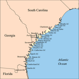 Map of the Sea islands | |
 Sea Islands | |
| Geography | |
|---|---|
| Location | Atlantic Ocean |
| Total islands | Over 100 |
| Administration | |
United States | |
The Sea Islands are a chain of tidal and barrier islands on the Atlantic Ocean coast of the Southeastern United States. Numbering over 100, they are located between the mouths of the Santee and St. Johns Rivers along the coast of South Carolina, Georgia, and Florida. The largest of these is Johns Island in South Carolina. The Sea Islands, particularly Sapelo Island, are home to the Gullah people.
History[]
Settled by indigenous cultures over thousands of years, the islands were selected by Spanish colonists as sites for founding of colonial missions. Historically the Spanish influenced the Guale and Mocama chiefdoms by establishing Christian missions in their major settlements, from St. Catherine's Island south to Fort George Island (at present-day Jacksonville, Florida).[1]
After President Abraham Lincoln's Emancipation Proclamation became effective on January 1, 1863, more than 5,000 slaves on Union-occupied islands obtained their freedom.[2]
Major Sea Islands[]
South Carolina[]
Charleston County[]
|
|
|
Colleton County[]
Beaufort County[]
|
|
|
Georgia[]
Chatham County[]
|
|
|
Liberty County[]
|
McIntosh County[]
|
Glynn County[]
|
Camden County[]
|
Florida[]
Nassau County[]
Duval County[]
See also[]
- Sea Island cotton
- Carolina Gold rice
- Sea Island red peas
References[]
- ^ "Mission Santa Catalina de Guale", New Georgia Encyclopedia, 2008, accessed 13 May 2010
- ^ William Klingaman, Abraham Lincoln and the Road to Emancipation, 1861-1865 (NY: Viking Press, 2001), p. 234
- ^ https://web.archive.org/web/20060902045353/http://www.uscb.edu/a/Academics/Undergraduate/Research/Pritchards_Island/
Further reading[]
- Gibson, Count D. (1948). Sea Islands of Georgia—Their Geologic History. Athens, Georgia: University of Georgia Press. ISBN 9780820334943. Retrieved 3 July 2019.
External links[]
The Lowcountry of South Carolina | ||
|---|---|---|
| Counties |
|  |
| Major communities | ||
| Sea islands |
| |
| History & culture |
| |
| Military installations |
| |
| Natural areas |
| |
| Other articles | ||
Columbia (capital) | ||
| Regions |
| |
| Larger cities |
| |
| Smaller cities |
| |
| Towns |
| |
| CDPs |
| |
| Counties |
| |
| Topics |
| |
| Society |
| |

Atlanta (capital) | ||
| Topics |
| |
| Society |
| |
| Regions |
| |
| Largest cities |
| |
| Counties |
| |
| ||

Tallahassee (capital) | ||
| Topics |
| |
| History |
| |
| Geography |
| |
| Major hurricanes |
| |
| Society |
| |
| Regions |
| |
| Metro areas |
| |
| Largest cities |
| |
| Counties |
| |

- Sea Islands
- Barrier islands of the United States
- East Coast islands of the United States
- Islands of Florida
- Islands of Georgia (U.S. state)
- Islands of South Carolina
- Southeastern United States
- South Carolina in the American Civil War
- Lists of islands of the United States