South Carolina Lowcountry

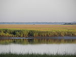
The Lowcountry (sometimes Low Country or just low country) is a geographic and cultural region along South Carolina's coast, including the Sea Islands. Once known for its slave-based agricultural wealth in rice and indigo, crops that flourished in the hot subtropical climate, the Lowcountry today is known for its historic cities and communities, natural environment, cultural heritage, and tourism industry.
Geography[]

The term "Low Country" originally was all the state below the Fall Line, or the Sandhills which run the width of the state from Aiken County to Chesterfield County. The Sandhills or Carolina Sandhills is a 15-60 km wide region within the Atlantic Coastal Plain province, along the inland margin of this province. The Carolina Sandhills are interpreted as eolian (wind-blown) sand sheets and dunes that were mobilized episodically from approximately 75,000 to 6,000 years ago.[1] Most of the published luminescence ages from the sand are coincident with the last glaciation, a time when the southeastern United States was characterized by colder air temperatures and stronger winds. The area above the Sandhills was known as "Upstate" or "Upcountry". These areas are different in geology, geography, and culture.
There are several variations on the geographic extent of the Lowcountry area. The most commonly accepted definition includes the counties of Beaufort, Colleton, Hampton, and Jasper; often described as the area between the Savannah and Ashley Rivers. These four are covered by the Lowcountry Council of Governments, a regional governmental entity charged with regional and transportation planning,[2] and are the ones included in the South Carolina Department of Parks, Recreation, and Tourism's "Lowcountry and Resort Islands" area.[3] The area includes the Hilton Head Island-Bluffton-Beaufort, SC Metropolitan Statistical Area.
References[]
- ^ Swezey, C.S., Fitzwater, B.A., Whittecar, G.R., Mahan, S.A., Garrity, C.P., Aleman Gonzalez, W.B., and Dobbs, K.M., 2016, "The Carolina Sandhills: Quaternary eolian sand sheets and dunes along the updip margin of the Atlantic Coastal Plain province, southeastern United States": Quaternary Research, v. 86, p. 271-286; www.cambridge.org/core/journals/quaternary-research
- ^ Lowcountry Council of Governments Archived September 5, 2015, at the Wayback Machine official website.
- ^ Tourism Regions (map) at South Carolina Department of Parks, Recreation, and Tourism official website.
The Lowcountry of South Carolina | ||
|---|---|---|
| Counties |
|  |
| Major communities |
| |
| Sea islands |
| |
| History & culture | ||
| Military installations |
| |
| Natural areas | ||
| Other articles | ||
Columbia (capital) | ||
| Regions |
| |
| Larger cities |
| |
| Smaller cities |
| |
| Towns |
| |
| CDPs | ||
| Counties |
| |
| Topics |
| |
| Society |
| |

Gullah people topics | ||||||||||||||
|---|---|---|---|---|---|---|---|---|---|---|---|---|---|---|
| Culture |
|   | ||||||||||||
| History |
| |||||||||||||
Coordinates: 33°07′34″N 80°00′32″W / 33.1260618°N 80.0087746°W

- Regions of South Carolina
- Gullah country