Chassenard
show This article may be expanded with text translated from the corresponding article in French. (December 2008) Click [show] for important translation instructions. |
Chassenard | |
|---|---|
Commune | |
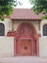 The church doors in Chassenard | |
show Location of Chassenard | |
 Chassenard | |
| Coordinates: 46°26′22″N 3°58′50″E / 46.4394°N 3.9806°ECoordinates: 46°26′22″N 3°58′50″E / 46.4394°N 3.9806°E | |
| Country | France |
| Region | Auvergne-Rhône-Alpes |
| Department | Allier |
| Arrondissement | Moulins |
| Canton | Dompierre-sur-Besbre |
| Intercommunality | Le Grand Charolais |
| Government | |
| • Mayor (2021–2026) | Fabrice Charles[1] |
| Area 1 | 25.12 km2 (9.70 sq mi) |
| Population (Jan. 2018)[2] | 1,008 |
| • Density | 40/km2 (100/sq mi) |
| Time zone | UTC+01:00 (CET) |
| • Summer (DST) | UTC+02:00 (CEST) |
| INSEE/Postal code | 03063 /03510 |
| Elevation | 222–281 m (728–922 ft) (avg. 240 m or 790 ft) |
| 1 French Land Register data, which excludes lakes, ponds, glaciers > 1 km2 (0.386 sq mi or 247 acres) and river estuaries. | |


Chassenard is a commune in the Allier department in central France.
Population[]
| Year | Pop. | ±% |
|---|---|---|
| 1962 | 867 | — |
| 1968 | 888 | +2.4% |
| 1975 | 855 | −3.7% |
| 1982 | 959 | +12.2% |
| 1990 | 1,017 | +6.0% |
| 1999 | 923 | −9.2% |
| 2007 | 918 | −0.5% |
| 2012 | 966 | +5.2% |
| 2017 | 989 | +2.4% |
| 2018 | 1,008 | +1.9% |
| Source: INSEE (1968–2017[3] and 2018) | ||
See also[]
- Communes of the Allier department
References[]
- INSEE commune file (in French)
- ^ Arnoux, Marielle (2 May 2021). "Chassenard. Fabrice Charles, le nouveau maire de la commune" [Chassenard. Fabrice Charles, the new mayor of the commune]. Le Journal de Saône-et-Loire (in French). Retrieved 3 May 2021.
- ^ "Populations légales 2018". INSEE. 28 December 2020.
- ^ Population history since 1968, INSEE (in French). Retrieved 3 May 2021.
| Wikimedia Commons has media related to Chassenard. |
| show Communes of the Allier department |
|---|
| Authority control |
|
|---|
This Allier geographical article is a stub. You can help Wikipedia by . |
Categories:
- Communes of Allier
- Allier geography stubs