Civil parishes in Lancashire

A civil parish is a subnational entity, forming the lowest unit of local government in England. There are 219 civil parishes in the ceremonial county of Lancashire; Blackpool is completely unparished; Pendle and Ribble Valley are entirely parished. At the 2001 census, there were 587,074 people living in the 219 parishes, accounting for 41.5 per cent of the county's population.
History[]
Parishes arose from Church of England divisions, and were originally purely ecclesiastical divisions. Over time they acquired civil administration powers.[1]
The Highways Act 1555 made parishes responsible for the upkeep of roads. Every adult inhabitant of the parish was obliged to work four days a year on the roads, providing their own tools, carts and horses; the work was overseen by an unpaid local appointee, the Surveyor of Highways.[2]
The poor were looked after by the monasteries, until their dissolution. In 1572, magistrates were given power to 'survey the poor' and impose taxes for their relief. This system was made more formal by the Poor Law Act 1601, which made parishes responsible for administering the Poor Law; overseers were appointed to charge a rate to support the poor of the parish.[3] The 19th century saw an increase in the responsibility of parishes, although the Poor Law powers were transferred to Poor Law Unions.[4] The Public Health Act 1872 grouped parishes into Rural Sanitary Districts, based on the Poor Law Unions; these subsequently formed the basis for Rural Districts.[5]
Parishes were run by vestries, meeting annually to appoint officials, and were generally identical to ecclesiastical parishes,[6] although some townships in large parishes administered the Poor Law themselves; under the Divided Parishes and Poor Law Amendment Act 1882, all extra-parochial areas and townships that levied a separate rate became independent civil parishes.[7]
Civil parishes in their modern sense date from the Local Government Act 1894, which abolished vestries; established elected parish councils in all rural parishes with more than 300 electors; grouped rural parishes into Rural Districts; and aligned parish boundaries with county and borough boundaries.[7] Urban civil parishes continued to exist, and were generally coterminous with the Urban District, Municipal Borough or County Borough in which they were situated; many large towns contained a number of parishes, and these were usually merged into one. Parish councils were not formed in urban areas, and the only function of the parish was to elect guardians to Poor Law Unions; with the abolition of the Poor Law system in 1930 the parishes had only a nominal existence.[8]
The Local Government Act 1972 retained civil parishes in rural areas, and many former Urban Districts and Municipal Boroughs that were being abolished, were replaced by new successor parishes; urban areas that were considered too large to be single parishes became unparished areas.[9]
The current position[]
Recent governments have encouraged the formation of town and parish councils in unparished areas, and the Local Government and Rating Act 1997 gave local residents the right to demand the creation of a new civil parish.[10]
A parish council can become a town council unilaterally, simply by resolution;[9] and a civil parish can also gain city status, but only if that is granted by the Crown.[9] The chairman of a town or city council is called a mayor.[9] The Local Government and Public Involvement in Health Act 2007 introduced alternative names: a parish council can now choose to be called a community; village; or neighbourhood council.[11]
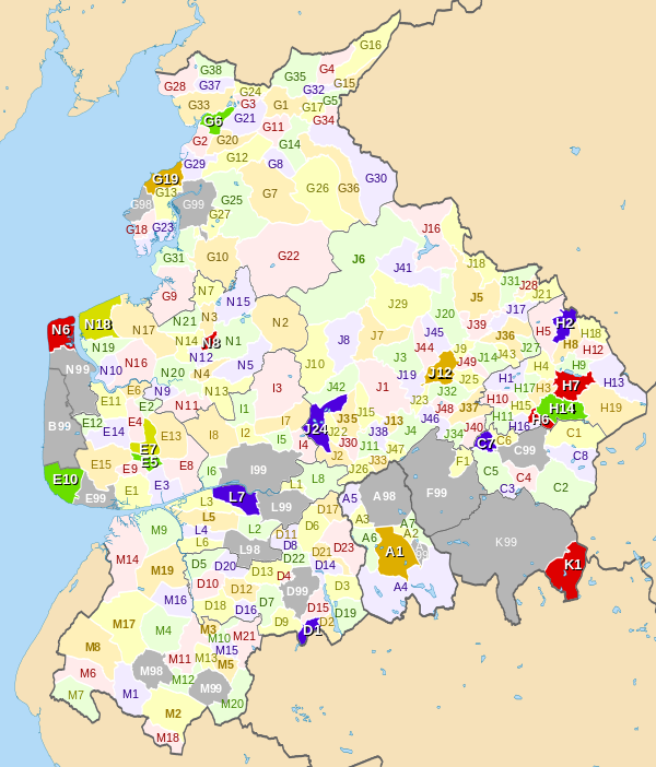
— — — — — Town parishes (in 2010)
— Unparished area (in 2010)
List of civil parishes and unparished areas[]
| Image | Name | Status | Population | District | Former local authority | Refs | Map ref |
|---|---|---|---|---|---|---|---|
 |
Blackburn | Unparished area | 97,058 | Blackburn with Darwen | Blackburn County Borough |
[12] [13] |
A98 |
 |
Darwen | Town | 27,495 | Blackburn with Darwen | Darwen Municipal Borough |
[14] [15] [16] |
A1 |
 |
Eccleshill | Civil parish | 276 | Blackburn with Darwen | Blackburn Rural District |
[17] [18] |
A2 |
 |
Hoddlesden | Unparished area | 1,292 | Blackburn with Darwen | Darwen Municipal Borough |
[14] [19] |
A99 |
 |
Livesey | Civil parish | 6,337 | Blackburn with Darwen | Blackburn Rural District |
[17] [18] |
A3 |
 |
North Turton | Civil parish | 3,736 | Blackburn with Darwen | Turton Urban District |
[20] [18] |
A4 |
 |
Pleasington | Civil parish | 467 | Blackburn with Darwen | Blackburn Rural District |
[17] [18] |
A5 |
 |
Tockholes | Civil parish | 454 | Blackburn with Darwen | Blackburn Rural District |
[17] [18] |
A6 |
 |
Yate and Pickup Bank | Civil parish | 355 | Blackburn with Darwen | Blackburn Rural District |
[17] [18] |
A7 |
 |
Blackpool | Unparished area | 142,283 | Blackpool | Blackpool County Borough |
[21] [22] |
B99 |
 |
Briercliffe | Civil parish | 3,187 | Burnley | Burnley Rural District |
[23] [24] |
C1 |
 |
Burnley | Unparished area | 64,925 | Burnley | Burnley County Borough |
[25] [26] |
C99 |
 |
Cliviger | Civil parish | 2,350 | Burnley | Burnley Rural District |
[23] [24] |
C2 |
 |
Dunnockshaw | Civil parish | 212 | Burnley | Burnley Rural District |
[23] [24] |
C3 |
 |
Habergham Eaves | Civil parish | 1,581 | Burnley | Burnley Rural District |
[23] [24] |
C4 |
 |
Hapton | Civil parish | 3,769 | Burnley | Burnley Rural District |
[23] [24] |
C5 |
 |
Ightenhill | Civil parish | 1,512 | Burnley | Burnley Rural District |
[23] [24] |
C6 |
 |
Padiham | Town | 8,998 | Burnley | Padiham Urban District |
[27] [24] |
C7 |
 |
Worsthorne-with-Hurstwood | Civil parish | 2,986 | Burnley | Burnley Rural District |
[23] [24] |
C8 |
 |
Adlington | Town | 5,270 | Chorley | Adlington Urban District |
[28] [29] |
D1 |
 |
Anderton | Civil parish | 1,206 | Chorley | Chorley Rural District |
[30] [29] |
D2 |
 |
Anglezarke | Civil parish | 23 | Chorley | Chorley Rural District |
[30] [29] |
D3 |
 |
Astley Village | Civil parish | 3,329 | Chorley | Chorley Municipal Borough |
[31] [29] |
D4 |
 |
Bretherton | Civil parish | 655 | Chorley | Chorley Rural District |
[30] [29] |
D5 |
 |
Brindle | Civil parish | 999 | Chorley | Chorley Rural District |
[30] [29] |
D6 |
 |
Charnock Richard | Civil parish | 1,885 | Chorley | Chorley Rural District |
[30] [29] |
D7 |
 |
Chorley | Unparished area | 31,556 | Chorley | Chorley Municipal Borough |
[31] [32] |
D99 |
 |
Clayton-le-Woods | Civil parish | 14,528 | Chorley | Chorley Rural District |
[30] [29] |
D8 |
 |
Coppull | Civil parish | 7,637 | Chorley | Chorley Rural District |
[30] [29] |
D9 |
 |
Croston | Civil parish | 2,679 | Chorley | Chorley Rural District |
[30] [29] |
D10 |
 |
Cuerden | Civil parish | 77 | Chorley | Chorley Rural District |
[30] [29] |
D11 |
 |
Eccleston | Civil parish | 4,353 | Chorley | Chorley Rural District |
[30] [29] |
D12 |
 |
Euxton | Civil parish | 8,318 | Chorley | Chorley Rural District |
[30] [29] |
D13 |
 |
Heapey | Civil parish | 955 | Chorley | Chorley Rural District |
[30] [29] |
D14 |
 |
Heath Charnock | Civil parish | 2,065 | Chorley | Chorley Rural District |
[30] [29] |
D15 |
 |
Heskin | Civil parish | 883 | Chorley | Chorley Rural District |
[30] [29] |
D16 |
 |
Hoghton | Civil parish | 867 | Chorley | Chorley Rural District |
[30] [29] |
D17 |
 |
Mawdesley | Civil parish | 1,787 | Chorley | Chorley Rural District |
[30] [29] |
D18 |
 |
Rivington | Civil parish | 144 | Chorley | Chorley Rural District |
[30] [29] |
D19 |
 |
Ulnes Walton | Civil parish | 2,048 | Chorley | Chorley Rural District |
[30] [29] |
D20 |
 |
Wheelton | Civil parish | 1,001 | Chorley | Chorley Rural District |
[30] [29] |
D21 |
 |
Whittle-le-Woods | Civil parish | 4,553 | Chorley | Chorley Rural District |
[30] [29] |
D22 |
 |
Withnell | Civil parish | 3,631 | Chorley | Withnell Urban District |
[33] [29] |
D23 |
 |
Bryning-with-Warton | Civil parish | 3,572 | Fylde | Fylde Rural District |
[34] [35] |
E1 |
 |
Elswick | Civil parish | 1,057 | Fylde | Fylde Rural District |
[34] [35] |
E2 |
 |
Freckleton | Civil parish | 6,045 | Fylde | Fylde Rural District |
[34] [35] |
E3 |
 |
Greenhalgh-with-Thistleton | Civil parish | 462 | Fylde | Fylde Rural District |
[34] [35] |
E4 |
 |
Kirkham | Town | 7,127 | Fylde | Kirkham Urban District |
[36] [35] |
E5 |
 |
Little Eccleston-with-Larbreck | Civil parish | 374 | Fylde | Fylde Rural District |
[34] [35] |
E6 |
 |
Lytham | Unparished area | 15,584 | Fylde | Lytham St Annes Municipal Borough |
[37] [38] |
E99 |
 |
Medlar-with-Wesham | Town | 3,245 | Fylde | Fylde Rural District |
[34] [35] |
E7 |
 |
Newton-with-Clifton | Civil parish | 2,680 | Fylde | Fylde Rural District |
[34] [35] |
E8 |
 |
Ribby-with-Wrea | Civil parish | 1,489 | Fylde | Fylde Rural District |
[34] [35] |
E9 |
 |
Saint Anne's on the Sea | Town | 25,743 | Fylde | Lytham St Annes Municipal Borough |
[37] [39] |
E10 |
 |
Singleton | Civil parish | 877 | Fylde | Fylde Rural District |
[34] [35] |
E11 |
 |
Staining | Civil parish | 2,312 | Fylde | Fylde Rural District |
[34] [35] |
E12 |
 |
Treales, Roseacre and Wharles | Civil parish | 447 | Fylde | Fylde Rural District |
[34] [35] |
E13 |
 |
Weeton-with-Preese | Civil parish | 1,096 | Fylde | Fylde Rural District |
[34] [35] |
E14 |
 |
Westby-with-Plumptons | Civil parish | 1,107 | Fylde | Fylde Rural District |
[34] [35] |
E15 |
 |
Accrington | Unparished area | 34,128 | Hyndburn | Accrington Municipal Borough |
[40] [41] |
F99 |
 |
Altham | Civil parish | 897 | Hyndburn | Burnley Rural District |
[23] [42] |
F1 |
 |
Church | Unparished area | 3,988 | Hyndburn | Church Urban District |
[43] [44] |
F99 |
 |
Clayton le Moors | Unparished area | 8,289 | Hyndburn | Clayton le Moors Urban District |
[45] [46] |
F99 |
 |
Great Harwood | Unparished area | 11,217 | Hyndburn | Great Harwood Urban District |
[47] [48] |
F99 |
 |
Oswaldtwistle | Unparished area | 15,627 | Hyndburn | Oswaldtwistle Urban District |
[49] [50] |
F99 |
 |
Rishton | Unparished area | 7,350 | Hyndburn | Rishton Urban District |
[51] [52] |
F99 |
 |
Aldcliffe-with-Stodday | Civil parish | 189 | Lancaster | Lancaster Municipal Borough |
[53][54] | G99 |
 |
Arkholme-with-Cawood | Civil parish | 334 | Lancaster | Lunesdale Rural District |
[55] [56] |
G1 |
 |
Bolton-le-Sands | Civil parish | 4,098 | Lancaster | Lancaster Rural District |
[57] [56] |
G2 |
 |
Borwick | Civil parish | 210 | Lancaster | Lunesdale Rural District |
[55] [56] |
G3 |
 |
Burrow-with-Burrow | Civil parish | 191 | Lancaster | Lunesdale Rural District |
[55] [56] |
G4 |
 |
Cantsfield | Civil parish | 76 | Lancaster | Lunesdale Rural District |
[55] [56] |
G5 |
 |
Carnforth | Town | 5,350 | Lancaster | Carnforth Urban District |
[58] [56] |
G6 |
 |
Caton-with-Littledale | Civil parish | 2,720 | Lancaster | Lunesdale Rural District |
[55] [56] |
G7 |
 |
Claughton | Civil parish | 132 | Lancaster | Lunesdale Rural District |
[55] [56] |
G8 |
 |
Cockerham | Civil parish | 558 | Lancaster | Lancaster Rural District |
[57] [56] |
G9 |
 |
Ellel | Civil parish | 2,521 | Lancaster | Lancaster Rural District |
[57] [56] |
G10 |
 |
Gressingham | Civil parish | 153 | Lancaster | Lunesdale Rural District |
[55] [56] |
G11 |
 |
Halton-with-Aughton | Civil parish | 2,360 | Lancaster | Lunesdale Rural District |
[55] [56] |
G12 |
 |
Heaton-with-Oxcliffe | Civil parish | 2,225 | Lancaster | Lancaster Rural District |
[57] [56] |
G13 |
 |
Heysham | Unparished area | 11,016 | Lancaster | Morecambe and Heysham Municipal Borough |
[59] [60] |
G98 |
 |
Hornby-with-Farleton | Civil parish | 729 | Lancaster | Lunesdale Rural District |
[55] [56] |
G14 |
 |
Ireby | Civil parish | 78 | Lancaster | Lunesdale Rural District |
[55] [56] |
G15 |
 |
Lancaster | Unparished area | 50,867 (including Aldcliffe-with-Stodday) | Lancaster | Lancaster Municipal Borough |
[53] [61] |
G99 |
 |
Leck | Civil parish | 189 | Lancaster | Lunesdale Rural District |
[55] [56] |
G16 |
 |
Melling-with-Wrayton | Civil parish | 290 | Lancaster | Lunesdale Rural District |
[55] [56] |
G17 |
 |
Middleton | Civil parish | 521 | Lancaster | Lancaster Rural District |
[57] [56] |
G18 |
 |
Morecambe | Town | 35,916 | Lancaster | Morecambe and Heysham Municipal Borough |
[59] [62] [63] |
G19 |
 |
Nether Kellet | Civil parish | 646 | Lancaster | Lunesdale Rural District |
[55] [56] |
G20 |
 |
Over Kellet | Civil parish | 778 | Lancaster | Lunesdale Rural District |
[55] [56] |
G21 |
 |
Over Wyresdale | Civil parish | 348 | Lancaster | Lancaster Rural District |
[57] [56] |
G22 |
 |
Overton | Civil parish | 1,015 | Lancaster | Lancaster Rural District |
[57] [56] |
G23 |
 |
Priest Hutton | Civil parish | 177 | Lancaster | Lancaster Rural District |
[57] [56] |
G24 |
 |
Quernmore | Civil parish | 532 | Lancaster | Lunesdale Rural District |
[55] [56] |
G25 |
 |
Roeburndale | Civil parish | 76 | Lancaster | Lunesdale Rural District |
[55] [56] |
G26 |
 |
Scotforth | Civil parish | 239 | Lancaster | Lancaster Rural District |
[57] [56] |
G27 |
 |
Silverdale | Civil parish | 1,545 | Lancaster | Lancaster Rural District |
[57] [56] |
G28 |
 |
Slyne-with-Hest | Civil parish | 3,163 | Lancaster | Lancaster Rural District |
[57] [56] |
G29 |
 |
Tatham | Civil parish | 393 | Lancaster | Lunesdale Rural District |
[55] [56] |
G30 |
 |
Thurnham | Civil parish | 595 | Lancaster | Lancaster Rural District |
[57] [56] |
G31 |
 |
Tunstall | Civil parish | 105 | Lancaster | Lunesdale Rural District |
[55] [56] |
G32 |
 |
Warton | Civil parish | 2,315 | Lancaster | Lancaster Rural District |
[57] [56] |
G33 |
 |
Wennington | Civil parish | 102 | Lancaster | Lunesdale Rural District |
[55] [56] |
G34 |
 |
Whittington | Civil parish | 359 | Lancaster | Lunesdale Rural District |
[55] [56] |
G35 |
 |
Wray-with-Botton | Civil parish | 521 | Lancaster | Lunesdale Rural District |
[55] [56] |
G36 |
 |
Yealand Conyers | Civil parish | 176 | Lancaster | Lancaster Rural District |
[57] [56] |
G37 |
 |
Yealand Redmayne | Civil parish | 295 | Lancaster | Lancaster Rural District |
[57] [56] |
G38 |
 |
Barley-with-Wheatley Booth | Civil parish | 271 | Pendle | Burnley Rural District |
[23] [64] |
H1 |
 |
Barnoldswick | Town | 10,859 | Pendle | Barnoldswick Urban District |
[65] [64] |
H2 |
 |
Barrowford | Civil parish | 6,039 | Pendle | Barrowford Urban District |
[66] [64] |
H3 |
 |
Blacko | Civil parish | 595 | Pendle | Burnley Rural District |
[23] [64] |
H4 |
 |
Bracewell and Brogden | Civil parish | 238 | Pendle | Skipton Rural District |
[67] [64] |
H5 |
 |
Brierfield | Town | 8,199 | Pendle | Brierfield Urban District |
[68] [64] |
H6 |
 |
Colne | Town | 18,117 | Pendle | Colne Municipal Borough |
[69] [70] [71] |
H7 |
 |
Earby | Civil parish | 4,348 | Pendle | Earby Urban District |
[72] [64] |
H18 |
 |
Foulridge | Civil parish | 1,506 | Pendle | Burnley Rural District |
[23] [64] |
H9 |
 |
Goldshaw Booth | Civil parish | 265 | Pendle | Burnley Rural District |
[23] [64] |
H10 |
 |
Higham-with-West Close Booth | Civil parish | 808 | Pendle | Burnley Rural District |
[23] [64] |
H11 |
 |
Kelbrook and Sough | Civil parish | 1,026 | Pendle | Earby Urban District |
[72] [64] |
H12 |
 |
Laneshaw Bridge | Civil parish | 759 | Pendle | Colne Municipal Borough |
[69] [64] |
H13 |
 |
Nelson | Town | 29,108 | Pendle | Nelson Municipal Borough |
[73] [74] [71] |
H14 |
 |
Old Laund Booth | Civil parish | 1,586 | Pendle | Burnley Rural District |
[23] [64] |
H15 |
 |
Reedley Hallows | Civil parish | 1,994 | Pendle | Burnley Rural District |
[23] [64] |
H16 |
 |
Roughlee Booth | Civil parish | 328 | Pendle | Burnley Rural District |
[23] [64] |
H17 |
 |
Salterforth | Civil parish | 625 | Pendle | Skipton Rural District |
[67] [64] |
H8 |
 |
Trawden Forest | Civil parish | 2,580 | Pendle | Trawden Urban District |
[75] [64] |
H19 |
 |
Barton | Civil parish | 1,096 | Preston | Preston Rural District |
[76] [77] |
I1 |
 |
Broughton | Civil parish | 1,735 | Preston | Preston Rural District |
[76] [77] |
I2 |
 |
Fulwood | Unparished area | 33,171 | Preston | Fulwood Urban District |
[78] [79] |
I99 |
 |
Goosnargh | Civil parish | 1,204 | Preston | Preston Rural District |
[76] [77] |
I3 |
 |
Grimsargh | Civil parish | 2,164 | Preston | Preston Rural District |
[76] [77] |
I4 |
 |
Haighton | Civil parish | 197 | Preston | Preston Rural District |
[76] [77] |
I5 |
 |
Ingol and Tanterton | Civil parish | Preston | [80] | I99 | ||
 |
Lea | Civil parish | 5,962 | Preston | Preston Rural District |
[76] [77] |
I6 |
 |
Preston | Unparished area | 79,864 (including Ingol and Tanterton) | Preston | Preston County Borough |
[81] [82] |
I99 |
 |
Whittingham | Civil parish | 2,189 | Preston | Preston Rural District |
[76] [77] |
I7 |
 |
Woodplumpton | Civil parish | 2,051 | Preston | Preston Rural District |
[76] [77] |
I8 |
 |
Aighton, Bailey and Chaigley | Civil parish | 1,249 | Ribble Valley | Clitheroe Rural District |
[83] [84] |
J1 |
 |
Balderstone | Civil parish | 379 | Ribble Valley | Blackburn Rural District |
[17] [84] |
J2 |
 |
Barrow | Civil parish | Ribble Valley | Clitheroe Rural District |
[85][83] [84] |
J48 | |
 |
Bashall Eaves | Civil parish | 162 | Ribble Valley | Bowland Rural District |
[86] [84] |
J3 |
 |
Billington and Langho | Civil parish | 4,555 | Ribble Valley | Blackburn Rural District |
[17] [84] |
J4 |
 |
Bolton-by-Bowland | Civil parish | 498 | Ribble Valley | Bowland Rural District |
[86] [84] |
J5 |
 |
Bowland Forest High | Civil parish | 163 | Ribble Valley | Bowland Rural District |
[86] [84] |
J6 |
 |
Bowland Forest Low | Civil parish | 168 | Ribble Valley | Bowland Rural District |
[86] [84] |
J7 |
 |
Bowland-with-Leagram | Civil parish | 128 | Ribble Valley | Clitheroe Rural District |
[83] [84] |
J8 |
 |
Chatburn | Civil parish | 1,104 | Ribble Valley | Clitheroe Rural District |
[83] [84] |
J9 |
 |
Chipping | Civil parish | 1,046 | Ribble Valley | Clitheroe Rural District |
[83] [84] |
J10 |
 |
Clayton-le-Dale | Civil parish | 1,142 | Ribble Valley | Blackburn Rural District |
[17] [84] |
J11 |
 |
Clitheroe | Town | 14,697 | Ribble Valley | Clitheroe Municipal Borough |
[87] [84] |
J12 |
 |
Dinckley | Civil parish | 83 | Ribble Valley | Blackburn Rural District |
[17] [84] |
J13 |
 |
Downham | Civil parish | 156 | Ribble Valley | Clitheroe Rural District |
[83] [84] |
J14 |
 |
Dutton | Civil parish | 212 | Ribble Valley | Preston Rural District |
[76] [84] |
J15 |
 |
Easington | Civil parish | 52 | Ribble Valley | Bowland Rural District |
[86] [84] |
J16 |
 |
Gisburn | Civil parish | 506 | Ribble Valley | Bowland Rural District |
[86] [84] |
J17 |
 |
Gisburn Forest | Civil parish | 137 | Ribble Valley | Bowland Rural District |
[86] [84] |
J18 |
 |
Great Mitton | Civil parish | 205 | Ribble Valley | Bowland Rural District |
[86] [84] |
J19 |
 |
Grindleton | Civil parish | 723 | Ribble Valley | Bowland Rural District |
[86] [84] |
J20 |
 |
Horton | Civil parish | 76 | Ribble Valley | Bowland Rural District |
[86] [84] |
J21 |
 |
Hothersall | Civil parish | 136 | Ribble Valley | Preston Rural District |
[76] [84] |
J22 |
 |
Little Mitton | Civil parish | 42 | Ribble Valley | Clitheroe Rural District |
[83] [84] |
J23 |
 |
Longridge | Town | 7,546 | Ribble Valley | Longridge Urban District |
[88] [84] |
J24 |
 |
Mearley | Civil parish | 25 | Ribble Valley | Clitheroe Rural District |
[83] [84] |
J25 |
 |
Mellor | Civil parish | 2,126 | Ribble Valley | Blackburn Rural District |
[17] [84] |
J26 |
 |
Middop | Civil parish | 43 | Ribble Valley | Bowland Rural District |
[86] [84] |
J27 |
 |
Newsholme | Civil parish | 50 | Ribble Valley | Bowland Rural District |
[86] [84] |
J28 |
 |
Newton | Civil parish | 237 | Ribble Valley | Bowland Rural District |
[86] [84] |
J29 |
 |
Osbaldeston | Civil parish | 165 | Ribble Valley | Blackburn Rural District |
[17] [84] |
J30 |
 |
Paythorne | Civil parish | 95 | Ribble Valley | Bowland Rural District |
[86] [84] |
J31 |
 |
Pendleton | Civil parish | 203 | Ribble Valley | Clitheroe Rural District |
[83] [84] |
J32 |
 |
Ramsgreave | Civil parish | 770 | Ribble Valley | Blackburn Rural District |
[17] [84] |
J33 |
 |
Read | Civil parish | 1,383 | Ribble Valley | Burnley Rural District |
[23] [84] |
J34 |
 |
Ribchester | Civil parish | 1,535 | Ribble Valley | Preston Rural District |
[76] [84] |
J35 |
 |
Rimington | Civil parish | 382 | Ribble Valley | Bowland Rural District |
[86] [84] |
J36 |
 |
Sabden | Civil parish | 1,371 | Ribble Valley | Burnley Rural District |
[23] [84] |
J37 |
 |
Salesbury | Civil parish | 391 | Ribble Valley | Blackburn Rural District |
[17] [84] |
J38 |
 |
Sawley | Civil parish | 305 | Ribble Valley | Bowland Rural District |
[86] [84] |
J39 |
 |
Simonstone | Civil parish | 1,152 | Ribble Valley | Burnley Rural District |
[23] [84] |
J40 |
 |
Slaidburn | Civil parish | 288 | Ribble Valley | Bowland Rural District |
[86] [84] |
J41 |
 |
Thornley-with-Wheatley | Civil parish | 327 | Ribble Valley | Clitheroe Rural District |
[83] [84] |
J42 |
 |
Twiston | Civil parish | 64 | Ribble Valley | Clitheroe Rural District |
[83] [84] |
J43 |
 |
Waddington | Civil parish | 878 | Ribble Valley | Bowland Rural District |
[86] [84] |
J44 |
 |
West Bradford | Civil parish | 730 | Ribble Valley | Bowland Rural District |
[86] [84] |
J45 |
 |
Whalley | Civil parish | 2,645 | Ribble Valley | Clitheroe Rural District |
[83] [84] |
J46 |
 |
Wilpshire | Civil parish | 2,569 | Ribble Valley | Blackburn Rural District |
[17] [84] |
J47 |
 |
Wiswell | Civil parish | 985 (including Barrow) | Ribble Valley | Clitheroe Rural District |
[83] [84] |
J48 |
 |
Worston | Civil parish | 76 | Ribble Valley | Clitheroe Rural District |
[83] [84] |
J49 |
 |
Bacup | Unparished area | 14,191 | Rossendale | Bacup Municipal Borough |
[89] [90] |
K99 |
 |
Edenfield | Unparished area | 3,544 | Rossendale | Ramsbottom Urban District |
[91] [92] |
K99 |
 |
Haslingden | Unparished area | 16,849 | Rossendale | Haslingden Municipal Borough |
[93] [94] |
K99 |
 |
Rawtenstall | Unparished area | 23,805 | Rossendale | Rawtenstall Municipal Borough |
[95] [96] |
K99 |
 |
Whitworth | Town | 7,263 | Rossendale | Whitworth Urban District |
[97] [98] |
K1 |
 |
Cuerdale | Civil parish | 36 | South Ribble | Preston Rural District |
[76] [99] |
L1 |
 |
Farington | Civil parish | 6,088 | South Ribble | Preston Rural District |
[76] [99] |
L2 |
 |
Hutton | Civil parish | 2,073 | South Ribble | Preston Rural District |
[76] [99] |
L3 |
 |
Leyland | Unparished area | 30,165 | South Ribble | Leyland Urban District |
[100] [101] |
L99 |
 |
Little Hoole | Civil parish | 1,815 | South Ribble | Preston Rural District |
[76] [99] |
L4 |
 |
Longton | Civil parish | 7,732 | South Ribble | Preston Rural District |
[76] [99] |
L5 |
 |
Much Hoole | Civil parish | 1,851 | South Ribble | Preston Rural District |
[76] [99] |
L6 |
 |
Penwortham | Town | 23,436 | South Ribble | Preston Rural District |
[76] [99] |
L7 |
 |
Samlesbury | Civil parish | 1,011 | South Ribble | Preston Rural District |
[76] [99] |
L8 |
 |
Walton le Dale | Unparished area | 29,660 | South Ribble | Walton le Dale Urban District |
[102] [103] |
L99 |
 |
Aughton | Civil parish | 8,342 | West Lancashire | West Lancashire Rural District |
[104] [105] |
M1 |
 |
Bickerstaffe | Civil parish | 1,196 | West Lancashire | West Lancashire Rural District |
[104] [105] |
M2 |
 |
Bispham | Civil parish | 207 | West Lancashire | West Lancashire Rural District |
[104] [105] |
M3 |
 |
Burscough | Civil parish | 8,968 | West Lancashire | Ormskirk Urban District |
[106] [105] |
M4 |
 |
Dalton | Civil parish | 348 | West Lancashire | Wigan Rural District |
[107] [105] |
M5 |
 |
Downholland | Civil parish | 966 | West Lancashire | West Lancashire Rural District |
[104] [105] |
M6 |
 |
Great Altcar | Civil parish | 243 | West Lancashire | West Lancashire Rural District |
[104] [105] |
M7 |
 |
Halsall | Civil parish | 1,873 | West Lancashire | West Lancashire Rural District |
[104] [105] |
M8 |
 |
Hesketh-with-Becconsall | Civil parish | 3,873 | West Lancashire | West Lancashire Rural District |
[104] [105] |
M9 |
 |
Hilldale | Civil parish | 633 | West Lancashire | Wigan Rural District |
[107] [105] |
M10 |
 |
Lathom | Civil parish | 890 | West Lancashire | Ormskirk Urban District |
[106] [105] |
M11 |
 |
Lathom South | Civil parish | 762 | West Lancashire | Ormskirk Urban District |
[106] [108] [109] |
M12 |
 |
Newburgh | Civil parish | 1,080 | West Lancashire | Ormskirk Urban District |
[106] [105] |
M13 |
 |
North Meols | Civil parish | 3,792 | West Lancashire | West Lancashire Rural District |
[104] [105] |
M14 |
 |
Ormskirk | Unparished area | 17,234 | West Lancashire | Ormskirk Urban District |
[106] [110] |
M98 |
 |
Parbold | Civil parish | 2,702 | West Lancashire | Wigan Rural District |
[107] [105] |
M15 |
 |
Rufford | Civil parish | 2,048 | West Lancashire | West Lancashire Rural District |
[104] [105] |
M16 |
 |
Scarisbrick | Civil parish | 3,204 | West Lancashire | West Lancashire Rural District |
[104] [105] |
M17 |
 |
Simonswood | Civil parish | 130 | West Lancashire | West Lancashire Rural District |
[104] [105] [111] |
M18 |
 |
Skelmersdale | Unparished area | 34,550 | West Lancashire | Skelmersdale and Holland Urban District |
[112] [113] |
M99 |
 |
Tarleton | Civil parish | 5,350 | West Lancashire | West Lancashire Rural District |
[104] [105] |
M19 |
 |
Up Holland | Civil parish | 7,180 | West Lancashire | Skelmersdale and Holland Urban District |
[112] [105] |
M20 |
 |
Wrightington | Civil parish | 2,807 | West Lancashire | Wigan Rural District |
[107] [105] |
M21 |
 |
Barnacre-with-Bonds | Civil parish | 1,751 | Wyre | Garstang Rural District |
[114] [115] |
N1 |
 |
Bleasdale | Civil parish | 147 | Wyre | Garstang Rural District |
[114] [115] |
N2 |
 |
Cabus | Civil parish | 1,572 | Wyre | Garstang Rural District |
[114] [115] |
N3 |
 |
Catterall | Civil parish | 1,981 | Wyre | Garstang Rural District |
[114] [115] |
N4 |
 |
Claughton | Civil parish | 562 | Wyre | Garstang Rural District |
[114] [115] |
N5 |
 |
Fleetwood | Town | 26,841 | Wyre | Fleetwood Municipal Borough |
[116] [117] [118] |
N6 |
 |
Forton | Civil parish | 1,253 | Wyre | Garstang Rural District |
[114] [115] |
N7 |
 |
Garstang | Town | 4,074 | Wyre | Garstang Rural District |
[114] [115] |
N8 |
 |
Great Eccleston | Civil parish | 1,473 | Wyre | Garstang Rural District |
[114] [115] |
N9 |
 |
Hambleton | Civil parish | 2,678 | Wyre | Garstang Rural District |
[114] [115] |
N10 |
 |
Inskip-with-Sowerby | Civil parish | 878 | Wyre | Garstang Rural District |
[114] [115] |
N11 |
 |
Kirkland | Civil parish | 343 | Wyre | Garstang Rural District |
[114] [115] |
N12 |
 |
Myerscough and Bilsborrow | Civil parish | 1,521 | Wyre | Garstang Rural District |
[114] [115] [119] |
N13 |
 |
Nateby | Civil parish | 475 | Wyre | Garstang Rural District |
[114] [115] |
N14 |
 |
Nether Wyresdale | Civil parish | 613 | Wyre | Garstang Rural District |
[114] [115] |
N15 |
 |
Out Rawcliffe | Civil parish | 567 | Wyre | Garstang Rural District |
[114] [115] |
N16 |
 |
Pilling | Civil parish | 1,739 | Wyre | Garstang Rural District |
[114] [115] |
N17 |
 |
Poulton-le-Fylde | Unparished area | 18,264 | Wyre | Poulton-le-Fylde Urban District |
[120] [121] |
N99 |
 |
Preesall | Town | 5,314 | Wyre | Preesall Urban District |
[122] [115] |
N18 |
 |
Stalmine-with-Staynall | Civil parish | 1,476 | Wyre | Garstang Rural District |
[114] [115] |
N19 |
 |
Thornton–Cleveleys | Unparished Area | 31,157 | Wyre | Thornton–Cleveleys Urban District |
[123] [124] |
N99 |
 |
Upper Rawcliffe-with-Tarnacre | Civil parish | 604 | Wyre | Garstang Rural District |
[114] [115] |
N20 |
 |
Winmarleigh | Civil parish | 335 | Wyre | Garstang Rural District |
[114] [115] |
N21 |
See also[]
- List of civil parishes in England
References[]
- ^ Angus Winchester, 2000, Discovering Parish Boundaries. Shire Publications. Princes Risborough, 96 pages ISBN 978-0-7478-0470-3
- ^ RAC Foundation : What Went Wrong? British Highway Development Before Motorways[permanent dead link] Retrieved 22 August 2009
- ^ The Victorian Web : The Poor Law : Introduction. Retrieved 22 August 2009
- ^ Staffordshire University : Poor Law Unions and Registration Districts Archived 14 September 2012 at archive.today Retrieved 22 August 2009
- ^ A Vision of Britain Through Time : Status Details for Rural Sanitary District. Retrieved 22 August 2009
- ^ Robert Tittler, The Reformation and the Towns in England, 1998, Oxford University Press, 395 pages, ISBN 978-0-19-820718-4
- ^ a b Modern British Surnames : Selected Events in the History of Civil Registration and Boundary Changes 1801-1996 Archived 1 August 2010 at the Wayback Machine Retrieved 22 August 2009
- ^ Alex MacMorran and T R Colquhoun Dill, The Local Government Act 1894 and the Subsequent Statutes Affecting Parish Councils, 1907, Butterworth and Co, London, 626 pages
- ^ a b c d Office of Public Sector Information : Local Government Act 1972 Archived 5 December 2012 at archive.today Retrieved 22 August 2009
- ^ Office of Public Sector Information : Local Government and Rating Act 1997 Archived 5 August 2012 at archive.today Retrieved 22 August 2009
- ^ Office of Public Sector Information : Local Government and Public Involvement in Health Act 2007 Archived 5 August 2012 at archive.today Retrieved 22 August 2009
- ^ A Vision of Britain Through Time : Blackburn County Borough. Retrieved 4 February 2010
- ^ Office for National Statistics : Census 2001 : Table KS01 : Usual Resident Population Archived 22 April 2015 at the Wayback Machine Audley; Bastwell; Beardwood with Lammack; Corporation Park; Ewood; Fernhurst; Higher Croft; Little Harwood; Meadowhead; Mill Hill; Queen's Park; Roe Lee; Shadsworth and Whitebirk; Shear Brow; and Wensley Fold wards. Retrieved 4 February 2010
- ^ a b A Vision of Britain Through Time : Darwen Municipal Borough. Retrieved 4 February 2010
- ^ Office for National Statistics : Census 2001 : Table KS01 : Usual Resident Population Archived 22 April 2015 at the Wayback Machine Earcroft; Marsh House; Sudell; Sunnyhurst; and Whitehall wards. Retrieved 4 February 2010
- ^ Darwen Town Council : First Meeting of Darwen Town Council : 17 June 2009 : Appendix 1 : A Copy of the Blackburn with Darwen Borough Council (Reorganisation of Community Governance) Order 2009. Retrieved 3 February 2010
- ^ a b c d e f g h i j k l m n A Vision of Britain Through Time : Blackburn Rural District Archived 14 May 2011 at the Wayback Machine Retrieved 4 February 2010
- ^ a b c d e f Office for National Statistics : Census 2001 : Parish Headcounts : Blackburn with Darwen. Retrieved 4 February 2010
- ^ Office for National Statistics : Census 2001 : Table KS01 : Usual Resident Population Archived 22 April 2015 at the Wayback Machine East Rural (part) ward. Retrieved 4 February 2010
- ^ A Vision of Britain Through Time : Turton Urban District Archived 25 October 2012 at the Wayback Machine Retrieved 4 February 2010
- ^ A Vision of Britain Through Time : Blackpool County Borough. Retrieved 4 February 2010
- ^ Office for National Statistics : Census 2001 : Table KS01 : Usual Resident Population Archived 22 April 2015 at the Wayback Machine Anchorsholme; Bispham; Bloomfield; Brunswick; Claremont; Clifton; Greenlands; Hawes Side; Highfield; Ingthorpe; Layton; Marton; Norbreck; Park; Squires Gate; Stanley; Talbot; Tyldesley; Victoria; Warbreck; and Waterloo wards. Retrieved 4 February 2010
- ^ a b c d e f g h i j k l m n o p q r s A Vision of Britain Through Time : Burnley Rural District Archived 14 May 2011 at the Wayback Machine Retrieved 4 February 2010
- ^ a b c d e f g h Office for National Statistics : Census 2001 : Parish Headcounts : Burnley Archived 3 March 2016 at the Wayback Machine Retrieved 4 February 2010
- ^ A Vision of Britain Through Time : Burnley County Borough Archived 1 July 2007 at the Wayback Machine Retrieved 4 February 2010
- ^ Office for National Statistics : Census 2001 : Table KS01 : Usual Resident Population Archived 22 April 2015 at the Wayback Machine Bank Hall; Briercliffe (part); Brunshaw; Coal Clough with Deerplay (part); Daneshouse with Stoneyholme; Gannow; Lanehead; Queensgate; Rosegrove with Lowerhouse (part); Rosehill with Burnley Wood; Trinity; and Whittlefield with Ightenhill (part) wards. Retrieved 4 February 2010
- ^ A Vision of Britain Through Time : Padiham Urban District. Retrieved 4 February 2010
- ^ A Vision of Britain Through Time : Adlington Urban District. Retrieved 5 February 2010
- ^ a b c d e f g h i j k l m n o p q r s t u v w Office for National Statistics : Census 2001 : Parish Headcounts : Chorley. Retrieved 5 February 2010
- ^ a b c d e f g h i j k l m n o p q r s t A Vision of Britain Through Time : Chorley Rural District Archived 15 August 2011 at the Wayback Machine Retrieved 5 February 2010
- ^ a b A Vision of Britain Through Time : Chorley Municipal Borough. Retrieved 5 February 2010
- ^ Office for National Statistics : Census 2001 : Table KS01 : Usual Resident Population Archived 22 April 2015 at the Wayback Machine Chorley East; Chorley North East; Chorley North West; Chorley South East; and Chorley South West wards. Retrieved 4 February 2010
- ^ A Vision of Britain Through Time : Withnell Urban District. Retrieved 7 February 2010
- ^ a b c d e f g h i j k l m A Vision of Britain Through Time : Fylde Rural District Archived 15 August 2011 at the Wayback Machine Retrieved 8 February 2010
- ^ a b c d e f g h i j k l m n Office for National Statistics : Census 2001 : Parish Headcounts : Fylde. Retrieved 8 February 2010
- ^ A Vision of Britain Through Time : Kirkham Urban District. Retrieved 8 February 2010
- ^ a b A Vision of Britain Through Time : Lytham St Annes Municipal Borough. Retrieved 8 February 2010
- ^ Office for National Statistics : Census 2001 : Table KS01 : Usual Resident Population Archived 22 April 2015 at the Wayback Machine Ansdell; Clifton; Fairhaven (part); Park (part); and St John's wards. Retrieved 4 February 2010
- ^ Office for National Statistics : Census 2001 : Table KS01 : Usual Resident Population Archived 22 April 2015 at the Wayback Machine Ashton; Central; Fairhaven (part); Heyhouses; Kilnhouse; Park (part) and St Leonards wards. Retrieved 4 February 2010
- ^ A Vision of Britain Through Time : Accrington Municipal Borough. Retrieved 9 February 2010
- ^ Office for National Statistics : Census 2001 : Table KS01 : Usual Resident Population Archived 22 April 2015 at the Wayback Machine Barnfield; Baxenden; Central; Church (part); Huncoat; Immanuel (part); Milnshaw; Peel; and Spring Hill wards. Retrieved 4 February 2010
- ^ Office for National Statistics : Census 2001 : Parish Headcounts : Hyndburn. Retrieved 9 February 2010
- ^ A Vision of Britain Through Time : Church Urban District. Retrieved 9 February 2010
- ^ Office for National Statistics : Census 2001 : Table KS01 : Usual Resident Population Archived 22 April 2015 at the Wayback Machine Altham (part); and Church (part) wards. Retrieved 4 February 2010
- ^ A Vision of Britain Through Time : Clayton le Moors Urban District. Retrieved 9 February 2010
- ^ Office for National Statistics : Census 2001 : Table KS01 : Usual Resident Population Archived 22 April 2015 at the Wayback Machine Altham (part); and Clayton le Moors wards. Retrieved 4 February 2010
- ^ A Vision of Britain Through Time : Great Harwood Urban District. Retrieved 9 February 2010
- ^ Office for National Statistics : Census 2001 : Table KS01 : Usual Resident Population Archived 22 April 2015 at the Wayback Machine Netherton; and Overton wards. Retrieved 4 February 2010
- ^ A Vision of Britain Through Time : Oswaldtwistle Urban District. Retrieved 9 February 2010
- ^ Office for National Statistics : Census 2001 : Table KS01 : Usual Resident Population Archived 22 April 2015 at the Wayback Machine Immanuel (part); St Andrew's; and St Oswald's wards. Retrieved 4 February 2010
- ^ A Vision of Britain Through Time : Rishton Urban District. Retrieved 9 February 2010
- ^ Office for National Statistics : Census 2001 : Table KS01 : Usual Resident Population Archived 22 April 2015 at the Wayback Machine Rishton ward. Retrieved 4 February 2010
- ^ a b A Vision of Britain Through Time : Lancaster Municipal Borough Archived 4 October 2007 at the Wayback Machine Retrieved 10 February 2010
- ^ "The Lancaster City Council (Reorganisation of Community Governance) Order 2017" (PDF). Lgbce. Retrieved 16 May 2018.
- ^ a b c d e f g h i j k l m n o p q r s t u A Vision of Britain Through Time : Lunesdale Rural District Archived 11 October 2007 at the Wayback Machine Retrieved 11 February 2010
- ^ a b c d e f g h i j k l m n o p q r s t u v w x y z aa ab ac ad ae af ag ah ai aj ak Office for National Statistics : Census 2001 : Parish Headcounts : Lancaster Archived 14 June 2012 at the Wayback Machine Retrieved 11 February 2010
- ^ a b c d e f g h i j k l m n o A Vision of Britain Through Time : Lancaster Rural District Archived 10 October 2007 at the Wayback Machine Retrieved 11 February 2010
- ^ A Vision of Britain Through Time : Carnforth Urban District. Retrieved 11 February 2010
- ^ a b A Vision of Britain Through Time : Morecambe and Heysham Municipal Borough Archived 14 May 2011 at the Wayback Machine Retrieved 10 February 2010
- ^ Office for National Statistics : Census 2001 : Table KS01 : Usual Resident Population Archived 22 April 2015 at the Wayback Machine Heysham Central; Heysham South; and Overton (part) wards. Retrieved 4 February 2010
- ^ Office for National Statistics : Census 2001 : Table KS01 : Usual Resident Population Archived 22 April 2015 at the Wayback Machine Bulk; Castle; Duke's; John O'Gaunt; Scotforth East; Scotforth West; Skerton East; Skerton West (part); and University (part) wards. Retrieved 4 February 2010
- ^ Office for National Statistics : Census 2001 : Table KS01 : Usual Resident Population Archived 22 April 2015 at the Wayback Machine Bare; Harbour; Heysham North; Poulton; Torrisholme (part); and Westgate (part) wards. Retrieved 4 February 2010
- ^ Lancaster City Council : Find Out More About Morecambe Parish Council Archived 23 July 2011 at the Wayback Machine Retrieved 27 October 2009
- ^ a b c d e f g h i j k l m n o p q Office for National Statistics : Census 2001 : Parish Headcounts : Pendle. Retrieved 23 May 2010
- ^ A Vision of Britain Through Time : Barnoldswick Urban District. Retrieved 23 May 2010
- ^ A Vision of Britain Through Time : Barrowford Urban District. Retrieved 23 May 2010
- ^ a b A Vision of Britain Through Time : Skipton Rural District Archived 14 May 2011 at the Wayback Machine Retrieved 23 May 2010
- ^ A Vision of Britain Through Time : Brierfield Urban District. Retrieved 23 May 2010
- ^ a b A Vision of Britain Through Time : Colne Municipal Borough. Retrieved 23 May 2010
- ^ Office for National Statistics : Census 2001 : Table KS01 : Usual Resident Population Archived 22 April 2015 at the Wayback Machine Boulsworth (part);; Foulridge (part); Horsfield; Vivary Bridge; and Waterside wards. Retrieved 23 May 2010
- ^ a b The Pendle (Parishes) Order 2008 Archived 14 March 2012 at the Wayback Machine Retrieved 23 May 2010
- ^ a b A Vision of Britain Through Time : Earby Urban District. Retrieved 23 May 2010
- ^ A Vision of Britain Through Time : Nelson Municipal Borough. Retrieved 24 May 2010
- ^ Office for National Statistics : Census 2001 : Table KS01 : Usual Resident Population Archived 22 April 2015 at the Wayback Machine Bradley; Brierfield (part); Clover Hill; Marsden; Southfield; Walverden and Whitefield wards. Retrieved 24 May 2010
- ^ A Vision of Britain Through Time : Trawden Urban District. Retrieved 25 May 2010
- ^ a b c d e f g h i j k l m n o p q r s A Vision of Britain Through Time : Preston Rural District Archived 1 October 2007 at the Wayback Machine Retrieved 24 May 2010
- ^ a b c d e f g h Office for National Statistics : Census 2001 : Parish Headcounts : Preston. Retrieved 26 July 2010
- ^ A Vision of Britain Through Time : Fulwood Urban District Archived 11 October 2007 at the Wayback Machine Retrieved 24 May 2010
- ^ Office for National Statistics : Census 2001 : Table KS01 : Usual Resident Population Archived 22 April 2015 at the Wayback Machine Brookfield (part); Cadley, College, Garrison; Greyfriars; and Sharoe Green wards. Retrieved 24 May 2010
- ^ "The City of Preston Council (Reorganisation of Community Governance) Order 2011" (PDF). Lgbce. Archived from the original (PDF) on 25 March 2016. Retrieved 13 March 2018.
- ^ A Vision of Britain Through Time : Preston County Borough. Retrieved 24 May 2010
- ^ Office for National Statistics : Census 2001 : Table KS01 : Usual Resident Population Archived 22 April 2015 at the Wayback Machine Ashton; Brookfield (part); Deepdale; Fishwick; Ingol; Larches; Moor Park; Ribbleton; Riversway; St George's; St Matthew's; Town Centre; Tulketh; and University wards. Retrieved 24 May 2010
- ^ a b c d e f g h i j k l m n A Vision of Britain Through Time : Clitheroe Rural District. Retrieved 31 July 2010
- ^ a b c d e f g h i j k l m n o p q r s t u v w x y z aa ab ac ad ae af ag ah ai aj ak al am an ao ap aq ar as at au av aw ax Office for National Statistics : Census 2001 : Parish Headcounts : Ribble Valley Archived 3 March 2016 at the Wayback Machine Retrieved 31 July 2010
- ^ "The Ribble Valley Borough Council (Reorganisation of Community Governance) Order 2014" (PDF). Lgbce. Retrieved 13 March 2018.
- ^ a b c d e f g h i j k l m n o p q r s A Vision of Britain Through Time : Bowland Rural District Archived 14 May 2011 at the Wayback Machine Retrieved 12 October 2010
- ^ A Vision of Britain Through Time : Clitheroe Municipal Borough. Retrieved 12 October 2010
- ^ A Vision of Britain Through Time : Longridge Urban District. Retrieved 13 October 2010
- ^ A Vision of Britain Through Time : Bacup Municipal Borough. Retrieved 4 February 2010
- ^ Office for National Statistics : Census 2001 : Table KS01 : Usual Resident Population Archived 22 April 2015 at the Wayback Machine Greensclough; Irwell; and Stacksteads wards. Retrieved 24 May 2010
- ^ A Vision of Britain Through Time : Ramsbottom Urban District Archived 25 October 2012 at the Wayback Machine Retrieved 4 February 2010
- ^ Office for National Statistics : Census 2001 : Table KS01 : Usual Resident Population Archived 22 April 2015 at the Wayback Machine Eden ward. Retrieved 24 May 2010
- ^ A Vision of Britain Through Time : Haslingden Municipal Borough. Retrieved 4 February 2010
- ^ Office for National Statistics : Census 2001 : Table KS01 : Usual Resident Population Archived 22 April 2015 at the Wayback Machine Greenfield; Helmshore; and Worsley wards. Retrieved 24 May 2010
- ^ A Vision of Britain Through Time : Rawtenstall Municipal Borough. Retrieved 4 February 2010
- ^ Office for National Statistics : Census 2001 : Table KS01 : Usual Resident Population Archived 22 April 2015 at the Wayback Machine Cribden; Goodshaw; Hareholme; Longholme; and Whitewell wards. Retrieved 24 May 2010
- ^ A Vision of Britain Through Time : Whitworth Urban District. Retrieved 14 October 2010
- ^ Office for National Statistics : Census 2001 : Parish Headcounts : Rossendale. Retrieved 4 February 2010
- ^ a b c d e f g h Office for National Statistics : Census 2001 : Parish Headcounts : South Ribble. Retrieved 24 May 2010
- ^ A Vision of Britain Through Time : Leyland Urban District. Retrieved 4 February 2010
- ^ Office for National Statistics : Census 2001 : Table KS01 : Usual Resident Population Archived 22 April 2015 at the Wayback Machine Earnshaw Bridge; Farington East (part); Golden Hill; Leyland Central; Leyland St Ambrose; Leyland St Mary's; Lowerhouse; Moss Side; and Seven Stars wards. Retrieved 24 May 2010
- ^ A Vision of Britain Through Time : Walton le Dale Urban District. Retrieved 24 May 2010
- ^ Office for National Statistics : Census 2001 : Table KS01 : Usual Resident Population Archived 22 April 2015 at the Wayback Machine Bamber Bridge East; Bamber Bridge North; Bamber Bridge West; Coupe Green and Gregson Lane; Lostock Hall; Samlesbury and Walton (part); Tardy Gate; and Walton le Dale wards. Retrieved 24 May 2010
- ^ a b c d e f g h i j k l A Vision of Britain Through Time : West Lancashire Rural District Archived 14 May 2011 at the Wayback Machine Retrieved 24 May 2010
- ^ a b c d e f g h i j k l m n o p q r s t Office for National Statistics : Census 2001 : Parish Headcounts : West Lancashire. Retrieved 24 May 2010
- ^ a b c d e A Vision of Britain Through Time : Ormskirk Urban District. Retrieved 24 May 2010
- ^ a b c d A Vision of Britain Through Time : Wigan Rural District Archived 25 October 2012 at the Wayback Machine Retrieved 24 May 2010
- ^ Office for National Statistics : Census 2001 : Table KS01 : Usual Resident Population Archived 22 April 2015 at the Wayback Machine Bickerstaffe (part); and Newburgh (part) wards. Retrieved 24 May 2010
- ^ The West Lancashire (Parish Electoral Arrangements and Electoral Changes) Order 2007. Retrieved 24 May 2010
- ^ Office for National Statistics : Census 2001 : Table KS01 : Usual Resident Population Archived 22 April 2015 at the Wayback Machine Derby; Knowsley; and Scott wards. Retrieved 24 May 2010
- ^ The Cheshire, Lancashire and Merseyside (County and Metropolitan Borough Boundaries) Order 1993. Retrieved 18 October 2010
- ^ a b A Vision of Britain Through Time : Skelmersdale and Holland Urban District. Retrieved 24 May 2010
- ^ Office for National Statistics : Census 2001 : Table KS01 : Usual Resident Population Archived 22 April 2015 at the Wayback Machine Ashurst; Birch Green; Digmoor; Moorside; Skelmersdale North; Skelmersdale South; and Tanhouse wards. Retrieved 24 May 2010
- ^ a b c d e f g h i j k l m n o p q r s A Vision of Britain Through Time : Garstang Rural District Archived 10 October 2007 at the Wayback Machine Retrieved 24 May 2010
- ^ a b c d e f g h i j k l m n o p q r s t Office for National Statistics : Census 2001 : Parish Headcounts : Wyre. Retrieved 24 May 2010
- ^ A Vision of Britain Through Time : Fleetwood Municipal Borough. Retrieved 24 May 2010
- ^ Office for National Statistics : Census 2001 : Table KS01 : Usual Resident Population Archived 22 April 2015 at the Wayback Machine Mount; Park; Pharos; Rossall; and Warren wards. Retrieved 24 May 2010
- ^ The Wyre Borough Council (Reorganisation of Community Governance) Order 2009 Archived 3 June 2012 at the Wayback Machine Retrieved 19 May 2010
- ^ The Wyre (Parishes) Order 2003. Retrieved 22 October 2010
- ^ A Vision of Britain Through Time : Poulton-le-Fylde Urban District. Retrieved 24 May 2010
- ^ Office for National Statistics : Census 2001 : Table KS01 : Usual Resident Population Archived 22 April 2015 at the Wayback Machine Breck; Carleton; Hardhorn; High Cross; and Tithebarn wards. Retrieved 24 May 2010
- ^ A Vision of Britain Through Time : Preesall Urban District Archived 11 October 2007 at the Wayback Machine Retrieved 24 May 2010
- ^ A Vision of Britain Through Time : Thornton–Cleveleys Urban District. Retrieved 24 May 2010
- ^ Office for National Statistics : Census 2001 : Table KS01 : Usual Resident Population Archived 22 April 2015 at the Wayback Machine Bourne; Cleveleys Park; Jubilee; Norcross; Staina; and Victoria wards. Retrieved 24 May 2010
External links[]
- Office for National Statistics : Geographical Area Listings
- Lancashire County Council : Parish Contact Details
- Blackburn with Darwen Borough Council : Town and Parish Councils
- Burnley Borough Council : Parish and Town Councils
- Chorley Council : Parish Council Contact Details
- Fylde Borough Council : Parish Councils
- Hyndburn Borough Council : Parish and Town Councils
- Lancaster City Council : Parish Councils
- Borough of Pendle : Parish Councils
- Preston City Council : Parish Council Contact Details
- Ribble Valley Borough Council : Parish Councils
- Rossendale Borough Council : Parish and Town Councils and Councillors
- South Ribble Borough Council : Parish and Town Councils
- West Lancashire Borough Council : Parish Councils
- Wyre Borough Council : Town and Parish Councillors by Council
- Civil parishes in Lancashire
- Populated places in Lancashire
- Lists of civil parishes in England
- Lancashire-related lists