Aighton, Bailey and Chaigley
| Aighton, Bailey and Chaigley | |
|---|---|
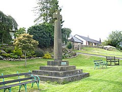 Boer War Memorial at Hurst Green | |
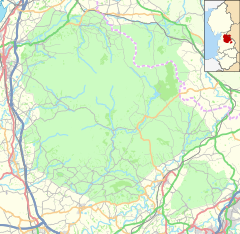
 Aighton, Bailey and Chaigley Location in Ribble Valley | |
| Area | 25.4318 km2 (9.8193 sq mi) |
| Population | 1,307 (2011)[1] |
| • Density | 51/km2 (130/sq mi) |
| OS grid reference | SD6837 |
| District | |
| Shire county | |
| Region | |
| Country | England |
| Sovereign state | United Kingdom |
| Post town | CLITHEROE |
| Postcode district | BB7 |
| Dialling code | 01254 |
| Police | Lancashire |
| Fire | Lancashire |
| Ambulance | North West |
| UK Parliament | |

Aighton, Bailey and Chaigley is a civil parish in the Borough of Ribble Valley in Lancashire, England, just west of Clitheroe. The population of the civil parish at the 2011 census was 1,307,[1] an increase from 1,249 in 2001.[2]
The main settlements in the parish are Hurst Green and Walker Fold. Other places are Aighton, Bailey and Chaigley, originally three hamlets forming a township. Stonyhurst College is located near to Hurst Green, within the parish.
History[]
Aighton was mentioned in 1870 in the Imperial Gazetteer of England and Wales by John Marius Wilson, who wrote:[3]
AIGHTON, one of three hamlets forming a township in the parish of Mitton, Lancashire. It lies near Hodder river, under Longridge fell, 3½ miles NNW of Whalley r. station, and 5 WSW of Clitheroe. It contains cotton factories, a workhouse, and the Roman Catholic college of Stonyhurst. The other hamlets of the township are Bailey and Chaighley. Acres in the three, 5,780. Real property, £6,726. Pop., 1,500. Houses, 244.
Governance[]
Aighton, Bailey and Chaigley was once a part of the ancient parish of Mitton. This became a civil parish in 1866, forming part of the Clitheroe Rural District from 1894 till 1974.[4]
Aighton, Bailey and Chaigley also gives its name to a ward of Ribble Valley Borough Council. [5][6] The ward elects a single councillor, who currently is Janet Alcock of the Conservative Party.[7]
See also[]
References[]
- ^ a b UK Census (2011). "Local Area Report – Aighton, Bailey and Chaigley Parish (1170215092)". Nomis. Office for National Statistics. Retrieved 26 February 2018.
- ^ Office for National Statistics : Census 2001 : Parish Headcounts : Ribble Valley Archived 3 March 2016 at the Wayback Machine Retrieved 31 July 2010
- ^ Stringer, Phil (9 February 2005). "Aighton". GENUKI. Archived from the original on 29 March 2008. Retrieved 17 April 2008.
- ^ "Aighton, Bailey and Chaigley Hmlt/CP through time". visionofbritain.org.uk. GB Historical GIS / University of Portsmouth. Retrieved 16 April 2016.
- ^ "Aighton, Bailey and Chaigley". MARIO. Lancashire County Council. Retrieved 16 April 2016.
- ^ "Aighton, Bailey and Chaigley". Ordnance Survey Linked Data Platform. Ordnance Survey. Retrieved 16 April 2016.
- ^ "Councillors by Ward: Aighton, Bailey and Chaigley". Ribble Valley Borough Council. Retrieved 16 April 2016.
External links[]
 Media related to Aighton, Bailey and Chaigley at Wikimedia Commons
- Aighton in the Domesday Book
- Geography of Ribble Valley
- Civil parishes in Lancashire
- Forest of Bowland