White Hill (Forest of Bowland)
This article does not cite any sources. (October 2010) |
| White Hill | |
|---|---|
 The valley of Croasdale, with the slopes of White Hill on the left. | |
| Highest point | |
| Elevation | 544 m (1,785 ft) |
| Prominence | c. 159 m |
| Parent peak | Ward's Stone |
| Listing | Marilyn |
| Coordinates | 54°01′24″N 2°30′02″W / 54.02325°N 2.50062°WCoordinates: 54°01′24″N 2°30′02″W / 54.02325°N 2.50062°W |
| Geography | |
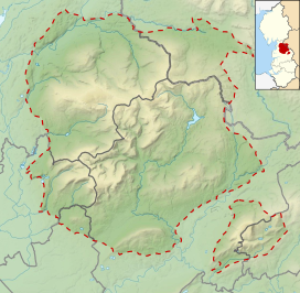 White Hill Location in the Forest of Bowland | |
| Location | Forest of Bowland, England |
| OS grid | SD673587 |
| Topo map | OS Landranger 103 |


White Hill is a hill in the Forest of Bowland, north-western England. It lies between Slaidburn and High Bentham. The summit houses a tower and a trig point. In medieval times, the hill marked one of the northernmost limits of the Lordship of Bowland.

This Lancashire location article is a stub. You can help Wikipedia by . |
Categories:
- Marilyns of England
- Hills of the Forest of Bowland
- Geography of Ribble Valley
- Geography of the City of Lancaster
- Mountains and hills of Lancashire
- Lancashire geography stubs