River Conder
| River Conder | |
|---|---|
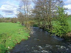 River Conder near Ellel | |
 Location of the mouth within Lancashire | |
| Location | |
| Country | United Kingdom |
| Part | England |
| County | Lancashire |
| Physical characteristics | |
| Mouth | Lune estuary |
• coordinates | 53°59′57.5″N 2°50′0″W / 53.999306°N 2.83333°WCoordinates: 53°59′57.5″N 2°50′0″W / 53.999306°N 2.83333°W |

The River Conder is a river in the English county of Lancashire.
The source of the River Conder is a spring at Conder Head on Black Fell near Littledale, from where the stream briefly runs north, then west through Cragg Wood. The river then skirts around Quernmore in a southwesterly direction through a disproportionately wide valley, created by glacial action.[1]
The river runs through Ellel and Galgate before turning to the north-west, flowing into the Lune estuary between Conder Green and Glasson Dock.
The river supplies most of the water for the Glasson Branch of the Lancaster Canal.[2]
The name of the river was recorded in the 13th century as Kondover and Kondoure, being derived from Brythonic and meaning "crooked waters".
See also[]
Notes[]
- ^ Conder Valley, near Lancaster, Ministry of Information. Retrieved 12 September 2006.
- ^ Self, John (2008). The Land of the Lune. Drakkar Press Limited.

This Lancashire location article is a stub. You can help Wikipedia by . |
- Rivers of Lancashire
- Rivers of Lancaster
- Lune catchment
- Lancashire geography stubs
- England river stubs