Carnforth
| Carnforth | |
|---|---|
 Carnforth railway station | |
 Carnforth Shown within the City of Lancaster district | |
| Population | 5,560 (2011) |
| OS grid reference | SD499704 |
| Civil parish |
|
| District |
|
| Shire county | |
| Region | |
| Country | England |
| Sovereign state | United Kingdom |
| Post town | CARNFORTH |
| Postcode district | LA5 |
| Dialling code | 01524 |
| Police | Lancashire |
| Fire | Lancashire |
| Ambulance | North West |
| UK Parliament | |


Carnforth is a market town and civil parish in the City of Lancaster in Lancashire, England, situated at the north east end of Morecambe Bay. The parish of Carnforth had a population of 5,350 recorded in the 2001 census,[1] and forms part of the City of Lancaster. The 2011 Census measured a population of 5,560.[2]
Due to the closeness of the coast and the hills, Carnforth is a popular base for walkers and cyclists exploring the area. The River Keer, the West Coast Main Line (WCML), the A6 and the Lancaster Canal pass through the town. The M6 motorway passes just to the east, linked to Carnforth by the A601(M).
History[]
The name "Carnforth" is thought to derive from its old function as a ford of the River Keer on which it is situated. Over time the descriptive name "Keer-ford" may have morphed into the modern "Carnforth". An alternative explanation is that the name derives from 'Chreneforde' and is Anglo-Saxon in origin, as cited in the Victoria County History of Lancashire.
Much of the history of Carnforth revolves around the railway and ironworks. Vast deposits of limestone located locally made Carnforth an ideal place for an ironworks, as limestone is a key component of the smelting process. In 1846 the Carnforth Ironworks Company established a works, located near the railway station. In the same year a recession occurred in the Earl of Dudley ironworks in Worcestershire, this meant there was a surplus of workers. A number of workers moved to the ironworks and lived in the nearby company village of Dudley (now called Millhead). In 1864 the Carnforth Haematite Company took over the works and production was vastly increased due to iron ore that was brought in by rail from the Furness Peninsula. By 1872 steel production became the main focus for the works using the new Bessemer process. By 1889 this process had failed.[citation needed] Iron production continued at the works until 1929 when it eventually closed down. The site was taken over by the War Department as an ordnance depot and remained as such until the 1960s. From then to the present the site is now an industrial estate consisting of several businesses.[3]
In the 19th century, Carnforth grew from a small village into a railway town when it became the junction of three major railways. With the closure of Carnforth MPD in 1968, the railway station facilities were reduced – the main line platforms were closed in May 1970 and subsequently removed when the line was electrified two years later. As a result, no express services on the West Coast Main Line (WCML) call at the town. The railway station is nowadays served by trains from Lancaster to Barrow and Leeds.
An important motive power depot was located to the west of the WCML and was one of the last to retain an allocation of steam locomotives until mid-1968. The buildings are now occupied by West Coast Railways[4] who still maintain and overhaul steam locos in their premises. The concrete locomotive coaling tower is a rare survivor.
From the 1920s to the 1980s Morphy's Mill, in Oxford Street, was a major employer of women in Carnforth. Contrary to its name it was not a mill but a factory making blouses and other garments.[5][6]
Brief Encounter[]
In 1945, Carnforth railway station was used as a set for the David Lean film Brief Encounter, starring Celia Johnson and Trevor Howard. Fans of this film were one of the major factors in the recent refurbishment of the railway station, including construction of a refreshment room to match the studio set used in the film, which is now run by the Carnforth Station Trust.[7][8]
- Gallery of film locations
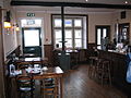
Carnforth railway station refreshment room - scene for much of the film

Carnforth railway station clock and ramp from subway under platforms


Governance[]
An electoral ward in the same name exists. This ward is smaller than the parish with a total population of 4,439.[9]
Carnforth is in the parliamentary constituency of Morecambe and Lunesdale, represented by Conservative David Morris.
Geography[]
Carnforth is on the A6 road 7 miles (11 km) north of Lancaster, Lancashire, to the west of the M6 motorway.
| show Destinations from Carnforth |
|---|
Demography[]
The Office for National Statistics recognises an area described as Carnforth Built-up area,[10] defined algorithmically, which includes Carnforth and Warton. It is divided into two parts: Carnforth subdivision,[11] which includes the Millhead area within Warton parish, and Warton subdivision.[12] The ONS definition of a built-up area includes built-up land separated by 200m from another settlement.[13]
| Named area | Population | Area | Population density | Note |
|---|---|---|---|---|
| Carnforth civil parish[2] | 5,560 | 6.09 km2 (2.35 sq mi) | 910/km2 (2,400/sq mi) | |
| Carnforth ward[14] | 4,439 | 5.33 km2 (2.06 sq mi) | 830/km2 (2,100/sq mi) | Excludes Crag Bank area |
| Carnforth Built-up area[10] | 7,920 | 2.33 km2 (0.90 sq mi) | 3,400/km2 (8,800/sq mi) | Comprises Carnforth and Warton Built-up area subdivisions |
| Carnforth Built-up area subdivision[11] | 6,115 | 1.75 km2 (0.68 sq mi) | 3,480/km2 (9,000/sq mi) | Includes Millhead area |
| Warton Built-up area subdivision[12] | 1,805 | 0.575 km2 (0.222 sq mi) | 3,140/km2 (8,100/sq mi) | Excludes Millhead area |
Health service[]
There is a general practice surgery in the town with eleven partners and four associate GPs. It has smaller surgeries in Arnside, Bolton-le-Sands, Halton, and Silverdale, to serve patients in outlying villages.[15] It is within the North Lancashire clinical commissioning group and patients are served by the University Hospitals of Morecambe Bay NHS Foundation Trust.
There is also an NHS clinic, adjacent to the GP practice, used for a variety of services.[16][17]
Education[]
Primary schools:
- Our Lady of Lourdes RC Primary School
- North Road Primary School
- Christ Church C of E Primary School
Secondary schools:
There is also a small public library within the town.[18]
Sport[]
The town has a rugby club Carnforth RUFC and football team Carnforth Rangers.
Notable people[]
The Conservative Party politician Cecil Parkinson was born in Carnforth in 1931 and became Baron Parkinson of Carnforth in 1992.
See also[]
References[]
- ^ "Parish headcount" (PDF). Lancashire County Council. Archived from the original (PDF) on 10 December 2006. Retrieved 10 January 2009.
- ^ Jump up to: a b UK Census (2011). "Local Area Report – Carnforth Parish (E04005183)". Nomis. Office for National Statistics. Retrieved 27 March 2021.
- ^ "Carnforth Canal Walks" (PDF). Simon Holt Marketing Services. p. 16. Retrieved 8 October 2007.
- ^ "Yorkshire and Scotland Steam Train Trips – Online Booking Now Available all operated by West Coast Railways". Westcoastrailways.co.uk. Retrieved 22 August 2012.
- ^ Jones, Sheila (2013). "Morphy's Mill (Part One)" (PDF). Mourholme Magazine of Local History. 63: 4–10. Retrieved 6 March 2016.
- ^ Jones, Sheila (2013). "Morphy's Mill (Part Two)" (PDF). Mourholme Magazine of Local History. 64: 4–10. Retrieved 6 March 2016.
- ^ "Carnforth Station Heritage Centre – Home of Brief Encounter". Carnforth-station.co.uk. 17 October 2003. Retrieved 22 August 2012.
- ^ "Carnforth Station Heritage Centre – Home of Brief Encounter". Carnforthstation.co.uk. 17 October 2003. Retrieved 22 August 2012.
- ^ "Ward population 2011". Retrieved 7 June 2015.
- ^ Jump up to: a b UK Census (2011). "Local Area Report – Carnforth Built-up area (E34004850)". Nomis. Office for National Statistics. Retrieved 28 July 2021.
- ^ Jump up to: a b UK Census (2011). "Local Area Report – Carnforth Built-up area sub division (E35001435)". Nomis. Office for National Statistics. Retrieved 28 July 2021.
- ^ Jump up to: a b UK Census (2011). "Local Area Report – Warton Built-up area sub division (E35001003)". Nomis. Office for National Statistics. Retrieved 28 July 2021.
- ^ "2011 Built-up Areas - Methodology and Guidance" (PDF). Office for National Statistics. 2013. Retrieved 28 July 2021.
- ^ UK Census (2011). "Local Area Report – Carnforth Ward (as of 2011) (E05005225)". Nomis. Office for National Statistics. Retrieved 28 July 2021.
- ^ "Home page". Ash Trees Surgery. Retrieved 7 November 2017.
- ^ "Carnforth Clinic". NHS Property Services. Archived from the original on 7 November 2017. Retrieved 7 November 2017.
- ^ "Open repair clinics". Audiology. University Hospitals of Morecambe Bay. Retrieved 7 November 2017.
- ^ "Carnforth Library". Libraries. Lancashire County Council. Retrieved 7 November 2017.
External links[]
- Visit Carnforth Website – Tourism Website for Carnforth
- Carnforth Town Council – Official Website for the Town (parish) Council of Carnforth
- Carnforth: historical and genealogical information at GENUKI.
| show Authority control |
|---|
- Carnforth
- Towns in Lancashire
- Geography of the City of Lancaster
- Populated coastal places in Lancashire
- Morecambe Bay