Claritas Rupes
From Wikipedia, the free encyclopedia
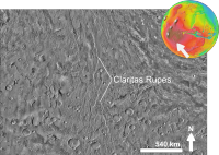 Claritas Rupes based on THEMIS day-time image | |
| Coordinates |  26°00′S 105°24′W / 26°S 105.4°W / -26; -105.4Coordinates: 26°00′S 105°24′W / 26°S 105.4°W / -26; -105.4 26°00′S 105°24′W / 26°S 105.4°W / -26; -105.4Coordinates: 26°00′S 105°24′W / 26°S 105.4°W / -26; -105.4 |
|---|---|

Claritas Rupes, as seen by HiRISE. Click on image to see layers. Scale bar is 1000 meters long.
Claritas Rupes is a scarp in the Phoenicis Lacus quadrangle of Mars, located at 26° South and 105.4° West. It is 924 km long and was named after an albedo feature at 25S, 110W.[1] The term "Rupes" is used in planetary geology to refer to an escarpments or cliff on Mars and other planets.[2] It is the Latin word for cliff.
References[]
| Wikimedia Commons has media related to Claritas Rupes. |
Geography and geology of Mars | |||||||||||||||
|---|---|---|---|---|---|---|---|---|---|---|---|---|---|---|---|
| |||||||||||||||
| |||||||||||||||
| |||||||||||||||
This article about the planet Mars or its moons is a stub. You can help Wikipedia by . |
- v
- t
Retrieved from ""
Categories:
- Phoenicis Lacus quadrangle
- Cliffs on Mars
- Mars stubs
Hidden categories:
- Coordinates on Wikidata
- Commons category link is on Wikidata
- All stub articles