Milankovič (Martian crater)
 Viking Orbiter 1 image (1978) | |
| Planet | Mars |
|---|---|
| Coordinates | 54°42′N 146°42′W / 54.7°N 146.7°WCoordinates: 54°42′N 146°42′W / 54.7°N 146.7°W |
| Quadrangle | Diacria quadrangle |
| Eponym | Milutin Milanković, a Serbian geophysicist and astrophysicist who lived from 1879 to 1958 |

Milankovič is a crater in the Diacria quadrangle of Mars, having a diameter of 118.4 km. It is located at 54.7° north latitude and 146.7° west longitude. The crater is easy to see on Mars photographs because it lies north of Olympus Mons and sits by itself in the flat plain of Vastitas Borealis.
It is named after Milutin Milanković (1879–1958), a Serbian geophysicist and astrophysicist.[1]
Gallery[]
Milankovič crater central area, as seen by HiRISE. The image shows dark dunes, dust devil tracks and boulders (small bright dots).

Map showing the location of Milankovic Crater
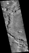
Milankovič crater, as seen by CTX camera on Mars Reconnaissance Orbiter.

Milankovič crater, as seen by CTX camera on Mars Reconnaissance Orbiter. Dark dots in center are dunes.
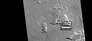
Depressions with straight southern walls, as seen by HiRISE under HiWish program. Box indicates part enlarged in images below. Image location is in Milankovič crater in Diacria quadrangle.

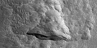
Enlargement of above image of straight walled depression, as seen by HiRISE under HiWish program. Note that the southern wall is dark compared to the northern wall.

Further enlargement of above image, as seen by HiRISE under HiWish program.

Viking Orbiter 2 image of clouds over Milankovič in February 1977


Exposed ice sheets[]
Many triangular shaped depressions are visible in Milankovič crater. According to a team of researchers, these depression display water ice in the straight wall that faces the pole. Eight sites were found with Milankovic crater being the only one in the northern hemisphere. This discovery is important because the ice lies under only a meter or two of cover. Research was conducted with instruments on board the Mars Reconnaissance Orbiter (MRO).[2][3][4][5][6]
The following images are ones referred to in this study of subsurface ice sheets.[7]

Wide view of part of Milankovic crater, as seen by HiRISE under HiWish program Many depressions here contain ice in their walls.

Close view of part of Milankovic crater, as seen by HiRISE under HiWish program This was one of the places were ice is especially evident. Image taken with HiRISE under HiWish program.

Close view from a previous image, as seen by HiRISE under HiWish program The triangular shape of some depressions are noted. The area in the box is enlarged in following images.
Close view of depression, as seen by HiRISE under HiWish program Straight, steep wall near the bottom faces the north pole.

Close view of depression, as seen by HiRISE under HiWish program Arrows indicate where there is a very thin, 1-2 meter covering on what is believed to be ice.


In culture[]
Milanković crater is the setting of the short story King of Mars, part of the Mars Mars 2194 by Canadian author Jack Stornoway.
Interactive Mars map[]

See also[]
- Diacria quadrangle
- Impact crater
- Impact event
- List of craters on Mars
- 1605 Milankovitch, minor planet
- Milankovič (lunar crater)
- Planetary nomenclature
References[]
- ^ "Archived copy". Archived from the original on 2002-02-08. Retrieved 2009-03-12.
{{cite web}}: CS1 maint: archived copy as title (link) - ^ Steep Slopes on Mars Reveal Structure of Buried Ice. NASA Press Release. 11 January 2018.
- ^ Ice cliffs spotted on Mars. Science News. Paul Voosen. 11 January 2018.
- ^ "Exposed subsurface ice sheets in the Martian mid-latitudes". 13 January 2018.
- ^ "Steep Slopes on Mars Reveal Structure of Buried Ice - SpaceRef".
- ^ Colin M. Dundas, et al. Science, 12 January 2018. Vol. 359, Issue 6372, pp. 199-201. doi:10.1126/science.aao1619
- ^ Supplementary Materials Exposed subsurface ice sheets in the Martian mid-latitudes Colin M. Dundas, Ali M. Bramson, Lujendra Ojha, James J. Wray, Michael T. Mellon, Shane Byrne, Alfred S. McEwen, Nathaniel E. Putzig, Donna Viola, Sarah Sutton, Erin Clark, John W. Holt
- Diacria quadrangle
- Impact craters on Mars