Cloghernagh
| Cloghernagh | |
|---|---|
| Clocharnach | |
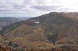
 Cloghernagh Mountain from Arts Lough | |
| Highest point | |
| Elevation | 800 m (2,600 ft)[1] |
| Prominence | 15 m (49 ft)[1] |
| Listing | Vandeleur-Lynam |
| Coordinates | 52°58′N 6°26′W / 52.967°N 6.433°WCoordinates: 52°58′N 6°26′W / 52.967°N 6.433°W[1] |
| Naming | |
| English translation | stoney place |
| Language of name | Irish |
| Geography | |
 Cloghernagh Location in Ireland | |
| Location | Wicklow, Ireland |
| Parent range | Wicklow Mountains |
| OSI/OSNI grid | T058918[1] |
| Topo map | OSi Discovery 56 |
| Geology | |
| Mountain type | Fine-grained, muscovite-rich aplogranite bedrock[1] |

Cloghernagh (Irish: Clocharnach, meaning 'Stoney place')[2] at 800 metres (2,600 ft), does not have the prominence to qualify as an Arderin,[3] but does have the prominence to be the 40th–highest peak on the Vandeleur-Lynam scale.[4][5] Cloghernagh is situated in the southern sector of the Wicklow Mountains range, and is part of the large massif of Lugnaquilla 925 metres (3,035 ft), Wicklow's highest mountain.[6][7]
Cloghernagh's northern side forms the steep southern walls and cliffs of the scenic U-shaped hanging valley of Fraughan Rock Glen, which then falls into the Glenmalure valley below; the scenic high corrie lake of Arts Lough 511 metres (1,677 ft), lies high on its north eastern flank.[7][6] Cloghernagh forms a "horseshoe" around the Fraughan Rock Glen with Lugnaquillia and Benleagh 689 metres (2,260 ft), and another "horseshoe shape" around the glen of the Carrawaystick River with Corrigasleggaun 794 metres (2,605 ft), and the corrie lake of Kelly's Lough.[8][7]
Bibliography[]
- Fairbairn, Helen (2014). Ireland's Best Walks: A Walking Guide. Collins Press. ISBN 978-1848892118.
- Fairbairn, Helen (2014). Dublin & Wicklow: A Walking Guide. Collins Press. ISBN 978-1848892019.
- MountainViews Online Database (Simon Stewart) (2013). A Guide to Ireland's Mountain Summits: The Vandeleur-Lynams & the Arderins. Collins Books. ISBN 978-1-84889-164-7.
- Dillion, Paddy (1993). The Mountains of Ireland: A Guide to Walking the Summits. Cicerone. ISBN 978-1852841102.
Gallery[]

View north to Benleagh
Cloghernagh and Arts Lough from Benleagh

View east down the Fraughan Rock Glen with Cloghernagh (right)
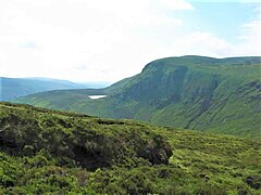
Cloghernagh and Arts Lough from Benleagh


See also[]
| Wikimedia Commons has media related to Cloghernagh. |
- Wicklow Way
- Wicklow Round
- Wicklow Mountains
- Lists of mountains in Ireland
- List of mountains of the British Isles by height
References[]
- ^ a b c d e "Cloghernagh". MountainViews Online Database. Retrieved 27 July 2019.
- ^ Paul Tempan (February 2012). "Irish Hill and Mountain Names" (PDF). MountainViews.ie.
- ^ Simon Stewart (October 2018). "Arderins: Irish mountains of 500+m with a prominence of 30m". MountainViews Online Database.
- ^ Simon Stewart (October 2018). "Vandeleur-Lynams: Irish mountains of 600+m with a prominence of 15m". MountainViews Online Database.
- ^ Mountainviews, (September 2013), "A Guide to Ireland's Mountain Summits: The Vandeleur-Lynams & the Arderins", Collins Books, Cork, ISBN 978-1-84889-164-7
- ^ a b Dillion, Paddy (1993). The Mountains of Ireland: A Guide to Walking the Summits. Cicerone. ISBN 978-1852841102.
Walk 10: Ballineddan Mountain, Slievemaan, Lugnaquillia, Camenabologue East Top, Camenabologue
- ^ a b c Fairbairn, Helen (2014). Ireland's Best Walks: A Walking Guide. Collins Press. ISBN 978-1848892118.
Route 65: Lugnaquilla
- ^ Fairbairn, Helen (2014). Dublin & Wicklow: A Walking Guide. Collins Press. ISBN 978-1848892019.
External links[]
- MountainViews: The Irish Mountain Website, Cloghernagh
- MountainViews: Irish Online Mountain Database
- The Database of British and Irish Hills , the largest database of British Isles mountains ("DoBIH")
- Hill Bagging UK & Ireland, the searchable interface for the DoBIH
| British Isles |  | |
|---|---|---|
| Scotland | ||
| Outside Scotland | ||
| England | ||
| Ireland |
| |
| County tops | ||

| Long-Distance |   | |
|---|---|---|
| Pilgrim path |
| |
| Cycle greenway | ||
| Boarded mountain |
| |
| Fell running | ||
This article related to the geography of County Wicklow, Ireland is a stub. You can help Wikipedia by . |
- Mountains and hills of County Wicklow
- Hewitts of Ireland
- Mountains under 1000 metres
- County Wicklow geography stubs