Conavalla
| Clonavalla | |
|---|---|
| Ceann an Bhealaigh | |
 Massif of Conavalla (centre) as seen from the shores of the Glendalough Upper Lake | |
| Highest point | |
| Elevation | 734 m (2,408 ft)[1] |
| Prominence | 109 m (358 ft)[1] |
| Listing | 100 Highest Irish Mountains, Hewitt, Arderin, Simm, Vandeleur-Lynam |
| Coordinates | 53°00′55″N 6°27′9″W / 53.01528°N 6.45250°WCoordinates: 53°00′55″N 6°27′9″W / 53.01528°N 6.45250°W |
| Naming | |
| English translation | head of the road or pass |
| Language of name | Irish |
| Geography | |
 Clonavalla Location in Ireland | |
| Location | Wicklow, Ireland |
| Parent range | Wicklow Mountains |
| OSI/OSNI grid | T023959 |
| Topo map | OSi Discovery 56 |
| Geology | |
| Mountain type | Dark slate-schist, quartzite & coticule[1] |

Conavalla (Irish: Ceann an Bhealaigh, meaning 'head of the road or pass')[2] at 734 metres (2,408 ft), is the 69th–highest peak in Ireland on the Arderin scale,[3] and the 85th–highest peak on the Vandeleur-Lynam scale.[4][5] The summit of Conavalla sits just off the main "central spine" of the Wicklow mountains range in Ireland, as it runs from Kippure in the north, to Lugnaquillia in the south.[6][5] Conavalla's large massif to the north-east is described as a "wet and boggy barren plain" whose various shoulders dominate the head of the Glendalough valley, and the upper east-side of the Glenmalure valley.[6][5]
Naming[]
Irish academic Paul Tempan notes that the "pass" element of Conavalla's name likely refers to the various routes from the Blessington lakes area (e.g. the R756 road to the Wicklow Gap) in the west that crossed parts of Conavalla's boggy massif to get into the Glenmalure valley in the east (note that the Wicklow Gap can be used to access the neighboring Glendalough valley without having to cross Conavalla's massif).[2] (see § Art O'Neill below).
Geography[]
Convalla is situated in the southern section of the Wicklow Mountains range, and forms a horseshoe on a "boggy" massif, at the head of the Glenmalure valley, with its neighbours, Table Mountain 702 metres (2,303 ft), and Camenabologue 758 metres (2,487 ft).[6]
Conavalla also sits in another broad horseshoe around the Glendalough valley, with the hydroelectric station at Turlough Hill 681 metres (2,234 ft), and the mountains of Camaderry 699 metres (2,293 ft), Lugduff 652 metres (2,139 ft), and Mullacor 661 metres (2,169 ft).[5] Conavalla's large "boggy massif" dominates the head of the Glendalough valley stretching from its summit at the far-west side of the head of the valley, to Lough Firrib 650 metres (2,130 ft) on the east-side.[6] The massif also includes Three Lakes 620 metres (2,030 ft) to the north of the summit of Conavalla.[6]
Conavalla's prominence of 109 metres (358 ft) does not qualify it as a Marilyn, but it does rank it as the 39th-highest mountain in Ireland on the MountainViews Online Database, 100 Highest Irish Mountains, where the minimum prominence threshold is 100 metres.[7][5]
Art O'Neill[]
On Conavalla's northern slopes lies Art's Cross and Art's Plaque, dedicated to Art O'Neill, the brother of Hugh O'Neill, Earl of Tyrone, who died of exposure in January 1592 helping Hugh Roe O'Donnell to escape from Dublin Castle to the stronghold of Fiach McHugh O'Byrne in the valley of Glenmalure.[8]
Bibliography[]
- Fairbairn, Helen (2014). Dublin & Wicklow: A Walking Guide. Collins Press. ISBN 978-1848892019.
- Fairbairn, Helen (2014). Ireland's Best Walks: A Walking Guide. Collins Press. ISBN 978-1848892118.
- MountainViews Online Database (Simon Stewart) (2013). A Guide to Ireland's Mountain Summits: The Vandeleur-Lynams & the Arderins. Collins Books. ISBN 978-1-84889-164-7.
- Dillion, Paddy (1993). The Mountains of Ireland: A Guide to Walking the Summits. Cicerone. ISBN 978-1852841102.
Gallery[]

Summit cairn

Three Lakes
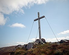
Art O'Neill's cross

Summit from Table Mountain

Lough Firrib

Conavalla Massif


See also[]
| Wikimedia Commons has media related to Conavalla. |
- Wicklow Way
- Wicklow Mountains
- Lists of mountains in Ireland
- List of mountains of the British Isles by height
- List of Hewitt mountains in England, Wales and Ireland
References[]
- ^ a b c "Conavalla". MountainViews Online Database. Retrieved 8 February 2019.
- ^ a b Paul Tempan (February 2012). "Irish Hill and Mountain Names" (PDF). MountainViews.ie.
- ^ Simon Stewart (October 2018). "Arderins: Irish mountains of 500+m with a prominence of 30m". MountainViews Online Database.
- ^ Simon Stewart (October 2018). "Vandeleur-Lynams: Irish mountains of 600+m with a prominence of 15m". MountainViews Online Database.
- ^ a b c d e Mountainviews, (September 2013), "A Guide to Ireland's Mountain Summits: The Vandeleur-Lynams & the Arderins", Collins Books, Cork, ISBN 978-1-84889-164-7
- ^ a b c d e Dillion, Paddy (1993). The Mountains of Ireland: A Guide to Walking the Summits. Cicerone. ISBN 978-1852841102.
Walk 8: Mullacor, Lugduff, Conavalla
- ^ "Irish Highest 100: The highest 100 Irish mountains with a prominence of +100m". MountainViews Online Database. September 2018.
- ^ Frank McNally (14 January 2017). "Hardship for Art's Sake – An Irishman's Diary about the Art O'Neill Challenge". Irish Times. Retrieved 18 July 2019.
External links[]
- MountainViews: The Irish Mountain Website, Conavalla
- MountainViews: Irish Online Mountain Database
- The Database of British and Irish Hills , the largest database of British Isles mountains ("DoBIH")
- Hill Bagging UK & Ireland, the searchable interface for the DoBIH
| British Isles |  | |
|---|---|---|
| Scotland | ||
| Outside Scotland | ||
| England | ||
| Ireland |
| |
| County tops | ||

| Long-Distance |   | |
|---|---|---|
| Pilgrim path |
| |
| Cycle greenway | ||
| Boarded mountain |
| |
| Fell running | ||
This article related to the geography of County Wicklow, Ireland is a stub. You can help Wikipedia by . |
- Mountains and hills of County Wicklow
- Hewitts of Ireland
- Mountains under 1000 metres
- County Wicklow geography stubs