Colere
Colere | |
|---|---|
| Comune di Colere | |
 | |
show Location of Colere | |
 Colere Location of Colere in Italy | |
| Coordinates: 45°58′N 10°5′E / 45.967°N 10.083°ECoordinates: 45°58′N 10°5′E / 45.967°N 10.083°E | |
| Country | Italy |
| Region | Lombardy |
| Province | Province of Bergamo (BG) |
| Area | |
| • Total | 18.8 km2 (7.3 sq mi) |
| Elevation | 1,013 m (3,323 ft) |
| Population (Dec. 2004)[2] | |
| • Total | 1,147 |
| • Density | 61/km2 (160/sq mi) |
| Demonym(s) | Coleresi |
| Time zone | UTC+1 (CET) |
| • Summer (DST) | UTC+2 (CEST) |
| Postal code | 24020 |
| Dialing code | 0346 |


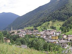
Colere (Bergamasque: Còler) is a comune (municipality) in the Province of Bergamo in the Italian region of Lombardy, located about 90 kilometres (56 mi) northeast of Milan and about 45 kilometres (28 mi) northeast of Bergamo. As of 31 December 2004, it had a population of 1,147 and an area of 18.8 square kilometres (7.3 sq mi).[3]
Colere borders the following municipalities: Angolo Terme, Azzone, Castione della Presolana, Rovetta, Vilminore di Scalve.
Demographic evolution[]

References[]
- ^ "Superficie di Comuni Province e Regioni italiane al 9 ottobre 2011". Istat. Retrieved 16 March 2019.
- ^ "Popolazione Residente al 1° Gennaio 2018". Istat. Retrieved 16 March 2019.
- ^ All demographics and other statistics: Italian statistical institute Istat.
External links[]
![]() Media related to Colere at Wikimedia Commons
Media related to Colere at Wikimedia Commons
This article on a location in the Province of Bergamo is a stub. You can help Wikipedia by . |
| Authority control |
|
|---|
Categories:
- Cities and towns in Lombardy
- Municipalities of the Province of Bergamo
- Province of Bergamo geography stubs