Gorle, Lombardy
Gorle | |
|---|---|
| Comune di Gorle | |
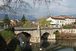 Bridge over the Serio River | |
show Location of Gorle | |
 Gorle Location of Gorle in Italy | |
| Coordinates: 45°42′14″N 9°43′09″E / 45.70389°N 9.71917°ECoordinates: 45°42′14″N 9°43′09″E / 45.70389°N 9.71917°E | |
| Country | Italy |
| Region | Lombardy |
| Province | Province of Bergamo (BG) |
| Area | |
| • Total | 2.4 km2 (0.9 sq mi) |
| Elevation | 268 m (879 ft) |
| Population (Dec. 2004)[2] | |
| • Total | 5,506 |
| • Density | 2,300/km2 (5,900/sq mi) |
| Demonym(s) | Gorlesi |
| Time zone | UTC+1 (CET) |
| • Summer (DST) | UTC+2 (CEST) |
| Postal code | 24020 |
| Dialing code | 035 |


Gorle (Bergamasque: Górel) is a comune (municipality) in the Province of Bergamo in the Italian region of Lombardy, located about 50 kilometres (31 mi) northeast of Milan and about 4 kilometres (2 mi) east of Bergamo. As of 31 December 2004, it had a population of 5,506 and an area of 2.4 square kilometres (0.93 sq mi).[3]
Gorle borders the following municipalities: Bergamo, Pedrengo, Ranica, Scanzorosciate, Seriate, Torre Boldone.
Demographic evolution[]

References[]
- ^ "Superficie di Comuni Province e Regioni italiane al 9 ottobre 2011". Istat. Retrieved 16 March 2019.
- ^ "Popolazione Residente al 1° Gennaio 2018". Istat. Retrieved 16 March 2019.
- ^ All demographics and other statistics: Italian statistical institute Istat.
This article on a location in the Province of Bergamo is a stub. You can help Wikipedia by . |
Categories:
- Cities and towns in Lombardy
- Municipalities of the Province of Bergamo
- Province of Bergamo geography stubs