Conflans-sur-Loing
Conflans-sur-Loing | |
|---|---|
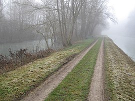 The Loing (left) and the canal du Loing (right) at Conflans-sur-Loing | |
 Coat of arms | |
show Location of Conflans-sur-Loing | |
 Conflans-sur-Loing | |
| Coordinates: 47°57′11″N 2°47′24″E / 47.9531°N 2.79°ECoordinates: 47°57′11″N 2°47′24″E / 47.9531°N 2.79°E | |
| Country | France |
| Region | Centre-Val de Loire |
| Department | Loiret |
| Arrondissement | Montargis |
| Canton | Châlette-sur-Loing |
| Intercommunality | |
| Government | |
| • Mayor (2020–2026) | Jérôme Ricardou[1] |
| Area 1 | 9.14 km2 (3.53 sq mi) |
| Population (Jan. 2018)[2] | 360 |
| • Density | 39/km2 (100/sq mi) |
| Demonym(s) | Conflanais |
| Time zone | UTC+01:00 (CET) |
| • Summer (DST) | UTC+02:00 (CEST) |
| INSEE/Postal code | 45102 /45700 |
| Elevation | 90–134 m (295–440 ft) |
| 1 French Land Register data, which excludes lakes, ponds, glaciers > 1 km2 (0.386 sq mi or 247 acres) and river estuaries. | |


Conflans-sur-Loing (French pronunciation: [kɔ̃flɑ̃ syʁ lwɛ̃], literally Conflans on Loing) is a commune in the Loiret department in north-central France.
See also[]
- Communes of the Loiret department
References[]
- ^ "Répertoire national des élus: les maires". data.gouv.fr, Plateforme ouverte des données publiques françaises (in French). 2 December 2020. Retrieved 7 December 2020.
- ^ "Populations légales 2018". INSEE. 28 December 2020.
| Wikimedia Commons has media related to Conflans-sur-Loing. |
| show Communes of the Loiret department |
|---|
| show Authority control |
|---|
This Loiret geographical article is a stub. You can help Wikipedia by . |
Categories:
- Communes of Loiret
- Loiret geography stubs