Corbin, Kansas
Corbin, Kansas | |
|---|---|
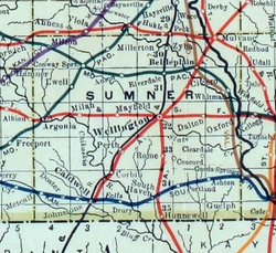 1915 Railroad Map of Sumner County | |
 | |
 Corbin 1915 Railroad Map of Sumner County | |
| Coordinates: 37°7′35″N 97°32′38″W / 37.12639°N 97.54389°WCoordinates: 37°7′35″N 97°32′38″W / 37.12639°N 97.54389°W | |
| Country | United States |
| State | Kansas |
| County | Sumner |
| Elevation | 1,161 ft (354 m) |
| Time zone | UTC-6 (CST) |
| • Summer (DST) | UTC-5 (CDT) |
| FIPS code | 20-15575 |
| GNIS ID | 470307 |


Corbin is an unincorporated community in Sumner County, Kansas, United States. It is located about 6.5 miles northeast of Caldwell near the intersection of S Mayfield Rd and W 110th St S, next to the railroad.
History[]
In 1887, the Chicago, Kansas and Nebraska Railway built a branch line north–south from Herington through Corbin to Caldwell.[1] It foreclosed in 1891 and was taken over by Chicago, Rock Island and Pacific Railway, which shut down in 1980 and reorganized as Oklahoma, Kansas and Texas Railroad, merged in 1988 with Missouri Pacific Railroad, merged in 1997 with Union Pacific Railroad. Most locals still refer to this railroad as the "Rock Island".
The post office was established February 6, 1884, and discontinued February 16, 1975.[2] The nearby Spring Creek School is on the National Register of Historic Places.
Education[]
The community is served by Caldwell USD 360 public school district.
References[]
- ^ "Rock Island Rail History". Archived from the original on 2011-06-19. Retrieved 2011-04-17.
- ^ "Kansas Post Offices, 1828-1961". Kansas Historical Society. Archived from the original on October 9, 2013. Retrieved 27 June 2014.
Further reading[]
External links[]
Municipalities and communities of Sumner County, Kansas, United States | ||
|---|---|---|
| Cities |  | |
| Unincorporated communities | ||
| Ghost towns | ||
| Footnotes | †This populated place is designated a Census-Designated Place (CDP) by the United States Census Bureau. ‡This populated place also has portions in an adjacent county or counties. | |
| ||
- Unincorporated communities in Sumner County, Kansas
- Unincorporated communities in Kansas
- Wichita, KS Metropolitan Statistical Area