Perth, Kansas
Perth, Kansas | |
|---|---|
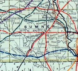 1915 Railroad Map of Sumner County | |
 | |
 Perth 1915 Railroad Map of Sumner County | |
| Coordinates: 37°10′29″N 97°30′19″W / 37.17472°N 97.50528°WCoordinates: 37°10′29″N 97°30′19″W / 37.17472°N 97.50528°W | |
| Country | United States |
| State | Kansas |
| County | Sumner |
| Elevation | 1,211 ft (369 m) |
| Time zone | UTC-6 (CST) |
| • Summer (DST) | UTC-5 (CDT) |
| FIPS code | 20-55500 |
| GNIS ID | 470305 |


Perth is an unincorporated community in Sumner County, Kansas, United States.[1] It is located about 9 miles southwest of Wellington near the intersection of S Clearwater Rd and W 80th St S, next to the railroad.
History[]
A post office was opened in Perth in 1882, and remained in operation until it was discontinued in 1954.[2]
Education[]
The community is served by Wellington USD 353 public school district.
Notable people[]
- Edward Gallagher (1887–1940), head coach of Oklahoma State Cowboys wrestling where he won 11 national championships from 1916 to 1940, born in Perth.
- George Kelly (1905–1967), psychologist, therapist, educator, considered the father of cognitive clinical psychology. He was born on a farm near Perth.
References[]
- ^ "Sumner County". Blue Skyways. Kansas State Library. Retrieved 27 June 2014.
- ^ "Kansas Post Offices, 1828-1961, page 2". Kansas Historical Society. Retrieved 27 June 2014.
Further reading[]
External links[]
- Sumner County Map, KDOT
Municipalities and communities of Sumner County, Kansas, United States | ||
|---|---|---|
| Cities |  | |
| Unincorporated communities | ||
| Ghost towns | ||
| Footnotes | †This populated place is designated a Census-Designated Place (CDP) by the United States Census Bureau. ‡This populated place also has portions in an adjacent county or counties. | |
| ||
Categories:
- Unincorporated communities in Sumner County, Kansas
- Unincorporated communities in Kansas