Hunnewell, Kansas
Hunnewell, Kansas | |
|---|---|
 Location within Sumner County and Kansas | |
 | |
| Coordinates: 37°0′16″N 97°24′26″W / 37.00444°N 97.40722°WCoordinates: 37°0′16″N 97°24′26″W / 37.00444°N 97.40722°W | |
| Country | United States |
| State | Kansas |
| County | Sumner |
| Founded | 1880 |
| Incorporated | 1882 |
| Named for | H. H. Hunnewell |
| Area | |
| • Total | 0.55 sq mi (1.43 km2) |
| • Land | 0.55 sq mi (1.43 km2) |
| • Water | 0.00 sq mi (0.00 km2) |
| Elevation | 1,115 ft (340 m) |
| Population | |
| • Total | 67 |
| • Estimate (2019)[3] | 64 |
| • Density | 115.94/sq mi (44.78/km2) |
| Time zone | UTC-6 (CST) |
| • Summer (DST) | UTC-5 (CDT) |
| ZIP code | 67140 |
| Area code | 620 |
| FIPS code | 20-33500 [4] |
| GNIS ID | 0470084 [5] |
Hunnewell is a city in Sumner County, Kansas, United States. As of the 2010 census, the city population was 67.[6]
History[]
Hunnewell was founded in 1880.[7] It was named for Boston financier and railway owner H. H. Hunnewell.[8][9]
In its heyday, Hunnewell was serving as a shipping point for Texas cattle, and was a prosperous cattle town during the 1880s. The provided quick access to the Kansas City, Kansas stockyards, and in the towns heyday it had one hotel, two general stores, one barber shop, two dance halls, and eight saloons. With little more than railroad workers and cowboys, violence was common. There were no lawmen to speak of during the 1880s in or around that area, and typically cattle rustling and other crimes were dealt with by the ranchers themselves. This culminated in the Hunnewell, Kansas Gunfight, on October 5, 1884.[10]
A post office was opened in Hunnewell in 1880, and remained in operation until it was discontinued in 1960.[11]
Geography[]
Hunnewell is located at 37°0′16″N 97°24′26″W / 37.00444°N 97.40722°W (37.004497, -97.407234).[12] According to the United States Census Bureau, the city has a total area of 0.49 square miles (1.27 km2), all of it land.[13]
Demographics[]
| Historical population | |||
|---|---|---|---|
| Census | Pop. | %± | |
| 1890 | 168 | — | |
| 1900 | 233 | 38.7% | |
| 1910 | 208 | −10.7% | |
| 1920 | 209 | 0.5% | |
| 1930 | 205 | −1.9% | |
| 1940 | 166 | −19.0% | |
| 1950 | 103 | −38.0% | |
| 1960 | 83 | −19.4% | |
| 1970 | 77 | −7.2% | |
| 1980 | 86 | 11.7% | |
| 1990 | 87 | 1.2% | |
| 2000 | 83 | −4.6% | |
| 2010 | 67 | −19.3% | |
| 2019 (est.) | 64 | [3] | −4.5% |
| U.S. Decennial Census | |||
2010 census[]
As of the census[2] of 2010, there were 67 people, 26 households, and 20 families residing in the city. The population density was 136.7 inhabitants per square mile (52.8/km2). There were 41 housing units at an average density of 83.7 per square mile (32.3/km2). The racial makeup of the city was 92.5% White, 6.0% Native American, and 1.5% from two or more races.
There were 26 households, of which 34.6% had children under the age of 18 living with them, 65.4% were married couples living together, 11.5% had a female householder with no husband present, and 23.1% were non-families. 19.2% of all households were made up of individuals, and 3.8% had someone living alone who was 65 years of age or older. The average household size was 2.58 and the average family size was 2.90.
The median age in the city was 42.3 years. 28.4% of residents were under the age of 18; 3.1% were between the ages of 18 and 24; 23.9% were from 25 to 44; 35.9% were from 45 to 64; and 9% were 65 years of age or older. The gender makeup of the city was 52.2% male and 47.8% female.
2000 census[]
As of the census[4] of 2000, there were 83 people, 24 households, and 21 families residing in the city. The population density was 173.4 people per square mile (66.8/km2). There were 34 housing units at an average density of 71.0 per square mile (27.3/km2). The racial makeup of the city was 97.59% White and 2.41% Native American.
There were 24 households, out of which 58.3% had children under the age of 18 living with them, 79.2% were married couples living together, 8.3% had a female householder with no husband present, and 12.5% were non-families. 8.3% of all households were made up of individuals, and 4.2% had someone living alone who was 65 years of age or older. The average household size was 3.46 and the average family size was 3.76.
In the city, the population was spread out, with 42.2% under the age of 18, 4.8% from 18 to 24, 27.7% from 25 to 44, 19.3% from 45 to 64, and 6.0% who were 65 years of age or older. The median age was 28 years. For every 100 females, there were 97.6 males. For every 100 females age 18 and over, there were 100.0 males.
The median income for a household in the city was $16,875, and the median income for a family was $49,375. Males had a median income of $67,917 versus $23,750 for females. The per capita income for the city was $12,729. There were 13.3% of families and 20.7% of the population living below the poverty line, including no under eighteens and none of those over 64.
Education[]
The community is served by South Haven USD 509 public school district.
Gallery[]
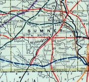
1915 Railroad Map of Sumner County

Imaginative drawing by reporter Marguerite Martyn of Mayor Ella Wilson of Hunnewell, her supporters and opponents, with a photo. The all-male city council was attempting to remove her. St. Louis Post-Dispatch, September 3, 1911


References[]
- ^ "2019 U.S. Gazetteer Files". United States Census Bureau. Retrieved July 24, 2020.
- ^ a b "U.S. Census website". United States Census Bureau. Retrieved 2012-07-06.
- ^ a b "Population and Housing Unit Estimates". United States Census Bureau. May 24, 2020. Retrieved May 27, 2020.
- ^ a b "U.S. Census website". United States Census Bureau. Retrieved 2008-01-31.
- ^ "US Board on Geographic Names". United States Geological Survey. 2007-10-25. Retrieved 2008-01-31.
- ^ "2010 City Population and Housing Occupancy Status". U.S. Census Bureau. Retrieved March 6, 2011.[dead link]
- ^ Blackmar, Frank Wilson (1912). Kansas: A Cyclopedia of State History, Embracing Events, Institutions, Industries, Counties, Cities, Towns, Prominent Persons, Etc. Standard Publishing Company. pp. 890.
- ^ Gannett, Henry (1905). The Origin of Certain Place Names in the United States. Govt. Print. Off. pp. 163.
- ^ Heim, Michael (2007). Exploring Kansas Highways. p. 23. ISBN 9780974435886.
- ^ "Complete List of Old West Gunfights (archived)". Legends of America. Archived from the original on March 21, 2008. Retrieved 26 March 2014.
- ^ "Kansas Post Offices, 1828-1961, page 2". Kansas Historical Society. Retrieved 27 June 2014.
- ^ "US Gazetteer files: 2010, 2000, and 1990". United States Census Bureau. 2011-02-12. Retrieved 2011-04-23.
- ^ "US Gazetteer files 2010". United States Census Bureau. Archived from the original on January 12, 2012. Retrieved 2012-07-06.
Further reading[]
External links[]
- Hunnewell - Directory of Public Officials
- Historic images of Hunnewell, Special Photo Collections at Wichita State University Library
- Hunnewell City Map, KDOT
Municipalities and communities of Sumner County, Kansas, United States | ||
|---|---|---|
| Cities |  | |
| Unincorporated communities | ||
| Ghost towns | ||
| Footnotes | †This community is designated a Census-Designated Place (CDP) by the United States Census Bureau. ‡This community also has portions in an adjacent county or counties. | |
| ||
- Cities in Kansas
- Cities in Sumner County, Kansas
- Wichita, KS Metropolitan Statistical Area