Rome, Sumner County, Kansas
Rome, Kansas | |
|---|---|
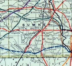 1915 Railroad Map of Sumner County | |
 | |
 Rome 1915 Railroad Map of Sumner County | |
| Coordinates: 37°9′37″N 97°23′29″W / 37.16028°N 97.39139°WCoordinates: 37°9′37″N 97°23′29″W / 37.16028°N 97.39139°W[1] | |
| Country | United States |
| State | Kansas |
| County | Sumner |
| Elevation | 1,102 ft (336 m) |
| Time zone | UTC-6 (CST) |
| • Summer (DST) | UTC-5 (CDT) |
| FIPS code | 20-61000 [1] |
| GNIS ID | 470318 [1] |


Rome is an unincorporated community in Sumner County, Kansas, United States. It is located about 6.5 miles south of Wellington at about 0.5 miles east of the intersection of U.S. Route 81 and E 90th St, next to the railroad.[1]
History[]
A post office was opened in Rome in 1874, and remained in operation until it was discontinued in 1933.[2]
Economy[]
Rome has a Farmers Co-Op Grain business with the capability to load grain into rail cars.
Education[]
The community is served by Wellington USD 353 public school district.[3]
References[]
- ^ a b c d e Geographic Names Information System (GNIS) details for Rome, Kansas; United States Geological Survey (USGS); October 13, 1978.
- ^ "Kansas Post Offices, 1828-1961, page 2". Kansas Historical Society. Retrieved March 10, 2020.
- ^ "USD 353 District Map" (PDF). Kansas Department of Transportation. Archived (PDF) from the original on February 29, 2020.
Further reading[]
External links[]
- Sumner County Map, KDOT
Municipalities and communities of Sumner County, Kansas, United States | ||
|---|---|---|
| Cities |  | |
| Unincorporated communities | ||
| Ghost towns | ||
| Footnotes | †This populated place is designated a Census-Designated Place (CDP) by the United States Census Bureau. ‡This populated place also has portions in an adjacent county or counties. | |
| ||
Categories:
- Unincorporated communities in Sumner County, Kansas
- Unincorporated communities in Kansas