Cove Creek Township, Washington County, Arkansas
Township of Cove Creek | |
|---|---|
 Location of Cove Creek Township in Washington County | |
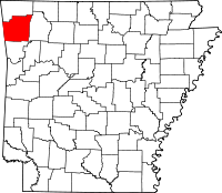 Location of Washington County in Arkansas | |
| Coordinates: 35°49′00″N 94°18′00″W / 35.81667°N 94.30000°WCoordinates: 35°49′00″N 94°18′00″W / 35.81667°N 94.30000°W | |
| Country | |
| State | |
| County | Washington |
| Established | 1842[1] |
| Area | |
| • Total | 45.9 sq mi (119 km2) |
| • Land | 45.9 sq mi (119 km2) |
| • Water | 0.0 sq mi (0 km2) 0% |
| Elevation | 1,781 ft (543 m) |
| Population | |
| • Total | 683 |
| • Density | 15/sq mi (6/km2) |
| Time zone | UTC-6 (CST) |
| • Summer (DST) | UTC-5 (CDT) |
| Area code(s) | 479 |
| GNIS feature ID | 69783 |
| U.S. Geological Survey Geographic Names Information System: Cove Creek Township, Washington County, Arkansas | |

Township of Cove Creek is one of 37 townships in Washington County, Arkansas, USA.[2] As of the 2000 census, its total population was 683. Part of Devil's Den State Park is located in Cove Creek Township.
Geography[]
According to the United States Census Bureau, Cove Creek Township covers an area of 45.9 square miles (119 km2); all land.[2] Cove Creek Township was created in 1842 from parts of . It gave part to Lee's Creek Township in 1880.[1]
Cities, towns, villages[]
Cemeteries[]
The township contains Dunkard, Liberty, Morrow, and Scott Cemeteries.
Major routes[]
References[]
- United States Census Bureau 2008 TIGER/Line Shapefiles
- United States Board on Geographic Names (GNIS)
- United States National Atlas
External links[]
Places adjacent to Cove Creek Township, Washington County, Arkansas | ||||||||||||||||
|---|---|---|---|---|---|---|---|---|---|---|---|---|---|---|---|---|
| ||||||||||||||||
Municipalities and communities of Washington County, Arkansas, United States | ||
|---|---|---|
| Cities |  | |
| Town | ||
| Townships | ||
| CDPs | ||
| Other unincorporated communities |
| |
| Ghost towns | ||
| Footnotes | ‡This populated place also has portions in an adjacent county or counties | |
| ||
Categories:
- Townships in Washington County, Arkansas
- Populated places established in 1842
- Townships in Arkansas