Creußen
show This article may be expanded with text translated from the corresponding article in German. (August 2012) Click [show] for important translation instructions. |
Creußen | |
|---|---|
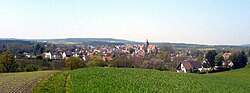 Panorama view of Creußen | |
 Coat of arms | |
show Location of Creußen within Bayreuth district | |
 Creußen | |
| Coordinates: 49°50′38.35″N 11°37′21.63″E / 49.8439861°N 11.6226750°ECoordinates: 49°50′38.35″N 11°37′21.63″E / 49.8439861°N 11.6226750°E | |
| Country | Germany |
| State | Bavaria |
| Admin. region | Oberfranken |
| District | Bayreuth |
| Municipal assoc. | Creußen |
| Government | |
| • Mayor (2020–26) | Martin Dannhäußer[1] |
| Area | |
| • Total | 64.89 km2 (25.05 sq mi) |
| Highest elevation | 640 m (2,100 ft) |
| Lowest elevation | 426 m (1,398 ft) |
| Population (2020-12-31)[2] | |
| • Total | 4,994 |
| • Density | 77/km2 (200/sq mi) |
| Time zone | UTC+01:00 (CET) |
| • Summer (DST) | UTC+02:00 (CEST) |
| Postal codes | 95473 |
| Dialling codes | 09270 |
| Vehicle registration | BT |
| Website | www.stadt-creussen.de |


Creußen is a town in the district of Bayreuth in Bavaria, Germany. It is situated on the Red Main river, 13 km southeast of Bayreuth.
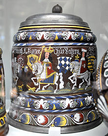

Creußen is famous for its stoneware beer steins.
Creußen is the starting point of the Red Main branch of the Main-Radweg bicycle path which stretches about 600 km along the Main until the mouth into the Rhine.
Notable people[]
- (1870–1950), German physicist and inventor
| Wikimedia Commons has media related to Creußen. |
References[]
- ^ Liste der ersten Bürgermeister/Oberbürgermeister in kreisangehörigen Gemeinden, Bayerisches Landesamt für Statistik, 15 July 2021.
- ^ "Tabellenblatt "Daten 2", Statistischer Bericht A1200C 202041 Einwohnerzahlen der Gemeinden, Kreise und Regierungsbezirke". Bayerisches Landesamt für Statistik (in German). June 2021.
| show Towns and municipalities in Bayreuth (district) |
|---|
| show Authority control |
|---|
This Bayreuth district location article is a stub. You can help Wikipedia by . |
Categories:
- Towns in Bavaria
- Bayreuth (district)
- Upper Franconia geography stubs