Plankenfels
Plankenfels | |
|---|---|
 Church of Saint Henry | |
 Coat of arms | |
show Location of Plankenfels within Bayreuth district | |
 Plankenfels | |
| Coordinates: 49°53′N 11°20′E / 49.883°N 11.333°ECoordinates: 49°53′N 11°20′E / 49.883°N 11.333°E | |
| Country | Germany |
| State | Bavaria |
| Admin. region | Oberfranken |
| District | Bayreuth |
| Municipal assoc. | Hollfeld |
| Subdivisions | 12 Ortsteile |
| Government | |
| • Mayor (2020–26) | Harald Wich[1] (CSU) |
| Area | |
| • Total | 14.01 km2 (5.41 sq mi) |
| Elevation | 390 m (1,280 ft) |
| Population (2020-12-31)[2] | |
| • Total | 870 |
| • Density | 62/km2 (160/sq mi) |
| Time zone | UTC+01:00 (CET) |
| • Summer (DST) | UTC+02:00 (CEST) |
| Postal codes | 95515 |
| Dialling codes | 09204 |
| Vehicle registration | BT |
| Website | www.plankenfels.de |


Plankenfels is a municipality in the district of Bayreuth in Bavaria in Germany.
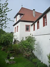
Plankenfels castle
References[]
- ^ Liste der ersten Bürgermeister/Oberbürgermeister in kreisangehörigen Gemeinden, Bayerisches Landesamt für Statistik, 15 July 2021.
- ^ "Tabellenblatt "Daten 2", Statistischer Bericht A1200C 202041 Einwohnerzahlen der Gemeinden, Kreise und Regierungsbezirke". Bayerisches Landesamt für Statistik (in German). June 2021.
| Wikimedia Commons has media related to Plankenfels. |
| show Towns and municipalities in Bayreuth (district) |
|---|
| Authority control |
|---|
This Bayreuth district location article is a stub. You can help Wikipedia by . |
Categories:
- Municipalities in Bavaria
- Bayreuth (district)
- Upper Franconia geography stubs