Hollfeld
Hollfeld | |
|---|---|
 Panorama of the Old Town of Hollfeld | |
 Coat of arms | |
show Location of Hollfeld within Bayreuth district | |
 Hollfeld | |
| Coordinates: 49°56′N 11°18′E / 49.933°N 11.300°ECoordinates: 49°56′N 11°18′E / 49.933°N 11.300°E | |
| Country | Germany |
| State | Bavaria |
| Admin. region | Oberfranken |
| District | Bayreuth |
| Government | |
| • Mayor (2020–26) | Hartmut Stern[1] |
| Area | |
| • Total | 81 km2 (31 sq mi) |
| Elevation | 403 m (1,322 ft) |
| Population (2020-12-31)[2] | |
| • Total | 5,024 |
| • Density | 62/km2 (160/sq mi) |
| Time zone | UTC+01:00 (CET) |
| • Summer (DST) | UTC+02:00 (CEST) |
| Postal codes | 96142 |
| Dialling codes | 09274 |
| Vehicle registration | BT |
| Website | www.hollfeld.de |


Hollfeld is a town in the district of Bayreuth, in Bavaria, Germany.
It is situated 20 km west of Bayreuth, and 30 km east of Bamberg.
Sport[]
The towns association football club, ASV Hollfeld, experienced its greatest success in 2012 when it qualified for the new northern division of the expanded Bayernliga, the fifth tier of the German football league system, where it played for two seasons until 2014.
Gallery[]
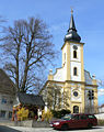
Mariä Himmelfahrt
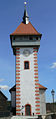
Gangolfsturm


Villages[]

|

|

|

|

|

|

|
| Drosendorf | Fernreuth | Freienfels | Gottelhof | Hainbach | Höfen | Hollfeld |

|

|

|

|

|

|

|
| Kainach | Krögelstein | Loch | Moggendorf | Neidenstein | Pilgerndorf | Schönfeld |

|

|

|

|

|

|

|
| Stechendorf | Tiefenlesau | Treppendorf | Weiher | Welkendorf | Wiesentfels | Wohnsdorf |
References[]
- ^ Liste der ersten Bürgermeister/Oberbürgermeister in kreisangehörigen Gemeinden, Bayerisches Landesamt für Statistik, 15 July 2021.
- ^ "Tabellenblatt "Daten 2", Statistischer Bericht A1200C 202041 Einwohnerzahlen der Gemeinden, Kreise und Regierungsbezirke". Bayerisches Landesamt für Statistik (in German). June 2021.
External links[]
| Wikimedia Commons has media related to Hollfeld. |
- Website (German)
| show Towns and municipalities in Bayreuth (district) |
|---|
| show Authority control |
|---|
This Bayreuth district location article is a stub. You can help Wikipedia by . |
Categories:
- Towns in Bavaria
- Bayreuth (district)
- Upper Franconia geography stubs