Crimée (Paris Métro)
Crimée | |||||||||||
|---|---|---|---|---|---|---|---|---|---|---|---|
| Paris Métro station | |||||||||||
 | |||||||||||
| Location | 19th arrondissement of Paris Île-de-France France | ||||||||||
| Coordinates | 48°53′30″N 2°22′37″E / 48.89158°N 2.37707°ECoordinates: 48°53′30″N 2°22′37″E / 48.89158°N 2.37707°E | ||||||||||
| Owned by | RATP | ||||||||||
| Operated by | RATP | ||||||||||
| Other information | |||||||||||
| Fare zone | 1 | ||||||||||
| History | |||||||||||
| Opened | 5 November 1910 | ||||||||||
| Services | |||||||||||
| |||||||||||
| Location | |||||||||||
 Crimée Location within Paris | |||||||||||

Crimée (French pronunciation: [kʁime] (![]() listen)) is a station of the Paris Métro. This station bears the name of the Crimean War (1855–56), on the Crimean Peninsula of the Russian Empire on the Black Sea, where a coalition of Turkey, the United Kingdom, France and Piedmont faced Russia. It was notable for the Siege of Sevastopol (1854–1855) and the Charge of the Light Brigade. The conflict ended in the Treaty of Paris (1856).
listen)) is a station of the Paris Métro. This station bears the name of the Crimean War (1855–56), on the Crimean Peninsula of the Russian Empire on the Black Sea, where a coalition of Turkey, the United Kingdom, France and Piedmont faced Russia. It was notable for the Siege of Sevastopol (1854–1855) and the Charge of the Light Brigade. The conflict ended in the Treaty of Paris (1856).
Nearby are la Villette Basin and the Canal de l'Ourcq.
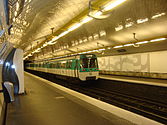
Station layout[]
| Street Level |
| B1 | Mezzanine for platform connection |
| Line 7 platforms | Side platform, doors will open on the right | |
| Southbound | ← | |
| Northbound | | |
| Side platform, doors will open on the right | ||
Gallery[]
| Wikimedia Commons has media related to Crimée (Paris Metro). |
References[]
- Roland, Gérard (2003). Stations de métro. D’Abbesses à Wagram. Éditions Bonneton.
| hide | |||||||
|---|---|---|---|---|---|---|---|
| Stations |
| ||||||
Categories:
- Paris Métro line 7
- Paris Métro stations in the 19th arrondissement of Paris
- Railway stations in France opened in 1910
- Paris Métro stubs