D11 motorway (Czech Republic)
This article needs additional citations for verification. (August 2008) |
 | |
|---|---|
| Dálnice D11 | |
 | |
| Route information | |
| Part of | |
| Length | 92 km (57 mi) Planned: 156 km (97 mi) |
| Major junctions | |
| From | |
| To | |
| Location | |
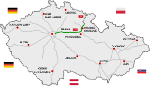
| Regions | Prague, Central Bohemian, Pardubice, Hradec Králové |
| Major cities | Prague, Hradec Králové |
| Highway system | |
| |

The D11 motorway (Czech: Dálnice D11) is a highway in the Czech Republic.
Plans to build a highway connecting Prague and Hradec Králové date from 1938; construction finally began in 1978. Today it consists of one continuous segment Praha - Poděbrady - Libice nad Cidlinou - Libčany - , reaching Hradec Králové. Another segment - - Smiřice - Jaroměř is under construction and last segment Jaroměř - Trutnov - border CZ/PL (polish expressway S3) is planned and waits for permits. It is part of European route E67 "Via Baltica" from Prague in the Czech Republic to Helsinki in Finland by way of Poland, Lithuania, Latvia, and Estonia. Three lanes in each direction are planned by 2025 between Prague and Jirny (8 km)[1] and to Poděbrady after 2025.
Unfinished sections[]
| Section | Length | Start of construction | Completion | Intersection |
|---|---|---|---|---|
| Hradec Králové – Smiřice | 15,46 km | 10/2018 | planned 12/2021 | Plotiště
Smiřice |
| Smiřice – Jaroměř | 7,39 km | 04/2018 | planned 12/2021 | Jaroměř-jih
Jaroměř-sever |
| Jaroměř – Trutnov | 19,63 km | planned
2025 |
planned
2028 |
Choustníkovo Hradiště
Kocbeře |
| Trutnov – state border with Poland | 21,28 km | planned
2024 |
planned
2027 |
Střítež
Poříčí Zlatá Olešnice Královec |
Images[]
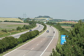
D11 motorway near Bříství, Nymburk District.

D11 motorway near Voleč, Pardubice Region.
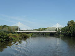
Bridge on D11 near Poděbrady


References[]
| hide Highways in the Czech Republic | ||
|---|---|---|
Coordinates: 50°6′59.62″N 15°12′9.01″E / 50.1165611°N 15.2025028°E

| Authority control: National libraries |
|---|
This Czech road or road transport-related article is a stub. You can help Wikipedia by . |
- Motorways in the Czech Republic
- Czech Republic geography stubs
- Europe road stubs
- Czech Republic transport stubs