D35 motorway (Czech Republic)
This article needs additional citations for verification. (August 2008) |
 | |
|---|---|
| Dálnice D35 | |
 | |
| Route information | |
| Length | 63 km (39 mi) Planned: 210 km (130 mi) |
| Major junctions | |
| From | 50°26′27.36″N 15°26′43.27″E / 50.4409333°N 15.4453528°E |
| |
| To | Liberec (in the future Zittau) 49°32′47.66″N 17°33′43.15″E / 49.5465722°N 17.5619861°E |
| Location | |
| Regions | Olomouc, Pardubice, Hradec Králové, Liberec |
| Major cities | Olomouc, Hradec Králové, Liberec |
| Highway system | |
| |

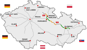
D35 motorway (Czech: Dálnice D35), formerly Expressway R35 (Czech: Rychlostní silnice R35) is a highway in the Czech Republic. If completed, it will be second longest highway in Czech Republic, running from Úlibice to the D1 at Lipník nad Bečvou.[1] After completion it will become alternative route to motorway D1 between Prague and Olomouc and Ostrava. The first segment was opened in the 1970s.
As of 2018 63 km of full motorway are in operation in two segments.[2]
Under construction[]
| Section | Length | Start of construction | Completion |
|---|---|---|---|
| Opatovice nad Labem – Časy | 12,61 km | 03/2019 | planned 12/2021[3] |
| Časy – Ostrov | 14,5 km | 12/2018 | planned 08/2022[4] |
Images[]

Highway D35 near Olomouc.
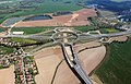
D35 near Opatovice nad Labem


References[]
- ^ "Planned construction progress on the road and motorway network" (PDF). . Retrieved 21 October 2018.
- ^ "Dálnice D35 (only CZ)".
- ^ "RSD (czech)" (PDF).
- ^ (PDF) https://mapapp.rsd.cz/Upload/Stavby/61/infoletak_d35-casy-ostrov.pdf. Missing or empty
|title=(help)
External links[]
- Info on motorway.cz (in English)
- Info on ceskedalnice.cz (in Czech)
- Info on dalnice-silnice.cz (in Czech)
- Ecology vs. R 35 (in Czech)
| hide Highways in the Czech Republic | ||
|---|---|---|
| Authority control: National libraries |
|---|
This Czech road or road transport-related article is a stub. You can help Wikipedia by . |
Categories:
- Motorways in the Czech Republic
- Proposed roads in the Czech Republic
- Czech Republic geography stubs
- Europe road stubs
- Czech Republic transport stubs