Door Village, Indiana
Door Village, Indiana | |
|---|---|
 Door Village Post site | |
 Door Village | |
| Coordinates: 41°34′29″N 86°46′08″W / 41.57472°N 86.76889°WCoordinates: 41°34′29″N 86°46′08″W / 41.57472°N 86.76889°W | |
| Country | United States |
| State | Indiana |
| County | LaPorte |
| Township | Scipio |
| Elevation | 810 ft (250 m) |
| ZIP code | 46350 |
| FIPS code | 18-18442[1] |
| GNIS feature ID | 450427[2] |


Door Village is an unincorporated community in Scipio Township, LaPorte County, Indiana. It was founded in 1836.[3]
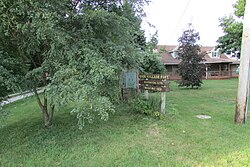
The site of the Old Fort at Door Village which was built in 1832 and a marker designates the site. A young man rode his Indian pony from Fort Dearborn to this part of the country to warn the settlers that Black Hawk and his Indians were coming on the warpath. The opening between the great forests which came down from the north and up from the south, was designated by the French voyageurs as "La Porte" or the door, from which La Porte County derived its name. The Marker is located on Joliet Road, on the north side near the intersection with Long Lane.
Joliet Road follows the Old Sauk Trail from the south side of present-day LaPorte to the Town Of Westville.
Geography[]
Door Village is located along the ancient Sauk Trail at 41°34′29″N 86°46′08″W / 41.57472°N 86.76889°W.
References[]
- ^ "U.S. Census website". United States Census Bureau. Retrieved 2008-01-31.
- ^ "Door Village, Indiana". Geographic Names Information System. United States Geological Survey. Retrieved 2009-10-10.
- ^ History of La Porte County, Indiana: Together with Sketches of Its Cities, Villages, and Townships. C. C. Chapman & Co. 1880. pp. 841.
| Wikimedia Commons has media related to Door Village, Indiana. |
Municipalities and communities of LaPorte County, Indiana, United States | ||
|---|---|---|
| Cities | ||
| Towns | ||
| Townships | ||
| CDPs | ||
| Other unincorporated communities |
| |
| Footnotes | ‡This populated place also has portions in an adjacent county or counties | |
| ||
This LaPorte County, Indiana location article is a stub. You can help Wikipedia by . |
- Unincorporated communities in LaPorte County, Indiana
- Unincorporated communities in Indiana
- LaPorte County, Indiana geography stubs