Eagar, Arizona
Eagar, Arizona | |
|---|---|
Town | |
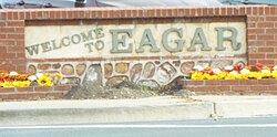 Welcome to Eagar, Arizona | |
| Motto(s): Where roads hit the trail | |
 Location of Eagar in Apache County, Arizona | |
 Eagar, Arizona Location in the United States | |
| Coordinates: 34°6′24″N 109°17′34″W / 34.10667°N 109.29278°WCoordinates: 34°6′24″N 109°17′34″W / 34.10667°N 109.29278°W | |
| Country | United States |
| State | Arizona |
| County | Apache |
| Government | |
| • Mayor | Bryce Hamblin |
| Area | |
| • Total | 11.59 sq mi (30.02 km2) |
| • Land | 11.58 sq mi (30.00 km2) |
| • Water | 0.01 sq mi (0.02 km2) |
| Elevation | 7,080 ft (2,158 m) |
| Population | |
| • Total | 4,885 |
| • Estimate (2019)[1] | 4,941 |
| • Density | 426.54/sq mi (164.69/km2) |
| Time zone | UTC-7 (MST) |
| ZIP code | 85925 |
| Area code | 928 |
| FIPS code | 04-20960 |
| GNIS feature ID | 28719 |
| Website | Town of Eagar |

Eagar is a town in Apache County, Arizona, United States. As of the 2010 census, the population of the town was 4,885.[4]
Eagar was first settled in 1871.[5]
Geography[]
Eagar is located at 34°6′24″N 109°17′34″W / 34.10667°N 109.29278°W (34.106703, -109.292725)[6] in southern Apache County, just north of Apache National Forest and at the foot of the White Mountains. Sunrise Park, the largest ski resort in Arizona, is located 25 miles (40 km) west of Eagar.
According to the United States Census Bureau, the town has a total area of 11.2 square miles (29.1 km2), of which 0.008 square miles (0.02 km2), or 0.07%, is water.[4] The town of Springerville borders Eagar to the north.
Climate[]
This region experiences warm (but not hot) and dry summers, with no average monthly temperatures above 71.6 °F. According to the Köppen Climate Classification system, Eagar has a warm-summer Mediterranean climate, abbreviated "Csb" on climate maps.[7]
Demographics[]
| Historical population | |||
|---|---|---|---|
| Census | Pop. | %± | |
| 1910 | 397 | — | |
| 1920 | 635 | 59.9% | |
| 1930 | 562 | −11.5% | |
| 1950 | 637 | — | |
| 1960 | 873 | 37.0% | |
| 1970 | 1,279 | 46.5% | |
| 1980 | 2,791 | 118.2% | |
| 1990 | 4,025 | 44.2% | |
| 2000 | 4,033 | 0.2% | |
| 2010 | 4,885 | 21.1% | |
| 2019 (est.) | 4,941 | [1] | 1.1% |
| U.S. Decennial Census[8] | |||
As of the census[9] of 2000, there were 4,033 people, 1,344 households, and 1,073 families residing in the town. The population density was 355.6 people per square mile (137.3/km2). There were 1,713 housing units at an average density of 151.1 per square mile (58.3/km2). The racial makeup of the town was 87.1% White, 3.4% Native American, 0.4% Black or African American, 0.1% Asian, 0.4% Pacific Islander, 4.9% from other races, and 3.8% from two or more races. 14.0% of the population were Hispanic or Latino of any race.
There were 1,344 households, out of which 45.7% had children under the age of 18 living with them, 65.5% were married couples living together, 11.4% had a female householder with no husband present, and 20.1% were non-families. 17.3% of all households were made up of individuals, and 7.3% had someone living alone who was 65 years of age or older. The average household size was 2.99 and the average family size was 3.38.
In the town, the age distribution of the population shows 36.2% under the age of 18, 7.6% from 18 to 24, 23.5% from 25 to 44, 23.5% from 45 to 64, and 9.2% who were 65 years of age or older. The median age was 33 years. For every 100 females, there were 95.7 males. For every 100 females age 18 and over, there were 91.8 males.
The median income for a household in the town was $37,378, and the median income for a family was $41,250. Males had a median income of $36,111 versus $21,274 for females. The per capita income for the town was $14,623. About 7.8% of families and 7.4% of the population were below the poverty line, including 5.8% of those under age 18 and 10.0% of those age 65 or over.
History[]
Eagar was settled by John Thomas Eagar (1851–1942) with his brothers Joel and William and another family named Robertson. He received deed to the land in 1878. However, the land was too high for ditch water to reach it until the "Big Ditch" was built to bring water high enough to irrigate the land.
Joseph and Emma Udall, bought the home of John Eagar on the corner of Center and Main street in the middle of Eagar, which was also the post office for many years. They built a 2nd floor which was then struck by lightning while they slept in it. At the time, the home was not irrigated, then irrigation was provided by the ditches and work of George Henry Crosby plus his family and church members. At that time, there was an "Outlaw highway" from Mexico to Canada, between Arizona, New Mexico, Utah, Colorado, etc.. Eagar, AZ, was less than five (5) miles from the New Mexico border. Because Federal Law enforcement was almost non-existent, the outlaws, would shift between states when state law enforcement officials came near. State officials could not chase the outlaws into another state, so the outlaws were safe. The outlaws loved the white mountains near Eagar because there were enough cows on the mountain for them to eat well by rustling cattle and they loved the climate in the summer months. However, the Mormons, for most of the summer took their cattle and sheep to the white mountains and camped with the animals. Collecting milk, making butter, branding the animals, etc. Unfortunately, the skeleton crew of Mormons irrigating and tending gardens back in Eagar, were no match for outlaws, when they came. Bishop Crosby cursed the east end of round valley, stopped ditch building on Nutrioso Creek and ceded the east end of town to the outlaws.
Bishop George Henry Crosby spearheaded the effort by the Mormons to build a ditch high enough to irrigate a larger area of Round Valley, higher than the small ditches then used in Springerville. Mormon leaders sent him to what was then called "Amity" because he had been a sheriff in St. George, Utah, before and there were a lot of lawless gangs in the area. To irrigate "Eagar", even though it was not called that at the time, he had no dynamite, so the Mormons in the area had to heat basalt volcanic rocks with fires, bring cold water from the river to pour over the hot rocks to break them, then drag the smaller rocks to the river to dam the river and create the Greer Lakes. Then the Mormons built the almost 30-mile (48 km) "Big Ditch" to travel the approximately 6-mile (10 km) distance, as the bird flies, to the top of Round Valley above "Eagar". George Crosby's own 18-year-old son was killed by a shovel over his head in a skirmish with another Mormon boy while building the ditch. During this time, the Clanton Gang, after the shootout at the O.K. Corral in Tombstone, AZ, settled in "Water Canyon" south of Eagar. Ike Clanton received mail in Eagar and was eventually killed in Water Canyon, less than one mile above the southernmost extent of the Big Ditch.
The first postmistress, Emma Goldsbrough Udall, wanted to name the town "Union", in a desire for eventually combining the town with other towns such as Amity and Springerville, to unite the small community. However, the US postmaster general rejected the name as too common. Therefore, she submitted the name "Eagarville" to honor the Eagar brothers. However, that name was also changed by the postmaster general to just "Eagar" sometime before December 1892 when the school district was renamed.[10]
A battle took place near what is now the town cemetery in which 9 members of the Snyder gang were killed.[10]
The town of Eagar was incorporated in 1948.[11]
Historic structures and markers[]
| Part of a series of the |
| Cities, towns and CDPs in Arizona with lists and images of historic properties, forts, cemeteries or historic districts |
|---|
The town of Eagar has various structures and locations which the town's historic society consider historical. These are identified with a marker which resemble a tombstone. Among them are those which have the markers description and which are pictured and listed here.[12]
- The 26 Bar Hereford Ranch – Once owned & often visited by film legend John Wayne, the ranch with the prominent white show barn came to fame in the 1940s as the Milky Way Hereford Ranch, owned by the Mars Candy Family.
- The Amity School Ruins – The stone chimney is all that remains of a one-room country schoolhouse that served pioneer Amity pop. 119 from the early 1880s until closing in April 1930.
- The Benjamin B. Crosby Home – An early 1900s adobe home built by the son of Eagar's first Mormon Bishop. Crosby, a major sheep & cattle rancher, was a railroad contractor who in 1917 laid the track for the Santa Fe Railroad north of here
- The Colter Ranch – Below among the large cottonwood trees are the historic hdqtrs of Fred T. Colter's Cross Bar Ranch. Originally homesteaded in 1881 by Texan Micajah Phelps, Colter built the ranch into one of the largest cattle operations in Northeastern AZ.
- The Eagar Elementary School – After the original frame school house burned in 1930, this building served Eagar's children for 53 years. Mothers prepared hot lunch across the street creating Eagar's own depression era "soup lines" at 5 cents a cup for the children.
- The Harry Colter Home – Completed in 1912 by J.P. LeSueur manager of the Eagar ACMI, this frame house with a skin of pressed metal wall sheathing is best known as home to one of the Colter Bros. important Round Valley Ranchers.
- The Joseph Udall Barn – Built in the early 1900s by one of Eagar's prominent civic, religious & business leaders, this barn was constructed with wooden pegs & retains remarkable architectural integrity. The 2-story brick farmhouse no longer stands.
- The Oscar Jepson Home – Built c.1892, this adobe structure once housed the Eagar School & later a bootlegger's still. Jepson purchased & enlarged the home in 1925 & moved his family from Alpine so his daughters could attend Round Valley High School.
- The Rencher Home – On July 24, 1900, the Peter P. Rencher family arrived from Texas in four wagons & set about building their place in Eagar. Completed in 1913, this 5 bedroom, red brick Colonial Revival home was the crown jewel of their labors.
- The Snyder-Cavanaugh Shoot Out – In 1878, this notorious outlaw gang clashed over dividing their loot. A heated gunfight occurred in the saddle of this hill .
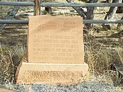
- Snyder/Cavanaugh Burial Ground – At least seven men died in the Snyder-Cavanaugh Shoot Out. when dirt was removed for the building of State Route 73 only the remains of three were found. These remains were relocated to this site and marked with a stone.[13]
- The William LeSueur Home – This handsome example of Colonial Revival architecture was home to the manager of Round Valley's ACMIs. His wife, the area's first registered nurse, boarded expectant mothers & teachers from the high school.

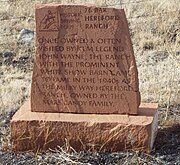
26 Bar Hereford Ranch Marker
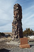
Amity School Ruins

Benjamin B. Crosby Home

Colter Ranch Marker
Eagar Elementary School

Harry Colter Home

Joseph Udall Barn

Oscar Jepson Home

Rencher Home
Snyder-Cavanaugh Shoot Out Marker

Snyder/Cavanaugh Burial Ground

William LeSueur Home


Town information[]
The current town mayor is Bryce Hamblin.[14] The town is home to the first enclosed high school football field, the Round Valley Ensphere.[15]
Notable people[]
- Joseph Isaac (Ike) Clanton (1847–1887), member of the Cowboys
- Milton William Cooper, conspiracy theorist (UFOs and Illuminati)
- Don Taylor Udall, state legislator and judge
- Jesse Addison Udall, state legislator and chief justice of the Arizona Supreme Court
- Joseph Udall (1860–1943), early settler, served on the Apache County Board of Supervisors for nearly 20 years
Education[]
Primary and secondary schools[]
The town is served by Round Valley Unified School District.
The town is served by three neighborhood schools: Round Valley Elementary School, Round Valley Middle School, and Round Valley High School.
In addition, White Mountain Academy, a K–12 charter school, is located in Eagar.
Public libraries[]
The Apache County Library District operates the Round Valley Public Library in Eagar.[16]
See also[]
- List of cities and towns in Arizona
- Transfer Station Fire
References[]
- ^ Jump up to: a b "Population and Housing Unit Estimates". United States Census Bureau. May 24, 2020. Retrieved May 27, 2020.
- ^ "U.S. Census website". United States Census Bureau. Retrieved 2014-08-28.
- ^ "2019 U.S. Gazetteer Files". United States Census Bureau. Retrieved June 30, 2020.
- ^ Jump up to: a b "Geographic Identifiers: 2010 Demographic Profile Data (G001): Eagar town, Arizona". U.S. Census Bureau, American Factfinder. Archived from the original on February 12, 2020. Retrieved April 16, 2013.
- ^ Andrew Jensen. Encyclopedic History of the Church. (Salt Lake City: Deseret News Press, 1941) p. 202
- ^ "US Gazetteer files: 2010, 2000, and 1990". United States Census Bureau. 2011-02-12. Retrieved 2011-04-23.
- ^ Climate Summary for Eagar, Arizona
- ^ "Census of Population and Housing". Census.gov. Retrieved June 4, 2016.
- ^ "U.S. Census website". United States Census Bureau. Retrieved 2008-01-31.
- ^ Jump up to: a b Byrd H. Granger (1960). Arizona Place Names. University of Arizona Press. p. 10. Retrieved 20 November 2011.
- ^ "Eagar, Arizona White Mountains". White Mountains Online. Retrieved 3 February 2017.
- ^ Historical Markers Data Base
- ^ The Pistols, Plows and Petticoats Historic Driving Tour Brochure.
- ^ Town of Eagar
- ^ Miner, Carrie. Off the Beaten Path Arizona: A Guide to Unique Places. p79. Google Books: [1]
- ^ "Round Valley Public Library[permanent dead link]." Apache County Library District. Retrieved on January 30, 2011.
External links[]
| Wikimedia Commons has media related to Eagar, Arizona. |
| show Municipalities and communities of Apache County, Arizona, United States |
|---|

| show Authority control |
|---|
- White Mountains (Arizona)
- Towns in Apache County, Arizona
- Populated places established in 1871
- 1871 establishments in Arizona Territory