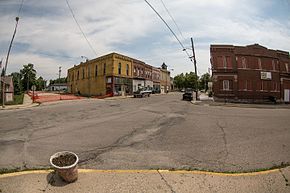
Eaton, Indiana
Eaton, Indiana | |
|---|---|
| Town of Eaton | |
 | |
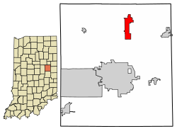 Location of Eaton in Delaware County, Indiana. | |
| Coordinates: 40°20′23″N 85°21′13″W / 40.33972°N 85.35361°WCoordinates: 40°20′23″N 85°21′13″W / 40.33972°N 85.35361°W | |
| Country | United States |
| State | Indiana |
| County | Delaware |
| Township | Hamilton, Union |
| Area | |
| • Total | 3.79 sq mi (9.82 km2) |
| • Land | 3.73 sq mi (9.65 km2) |
| • Water | 0.06 sq mi (0.16 km2) |
| Elevation | 886 ft (270 m) |
| Population | |
| • Total | 1,805 |
| • Estimate (2021)[6] | 1,725[2] |
| • Density | 456.20/sq mi (176.07/km2) |
| Time zone | UTC-5 (EST) |
| • Summer (DST) | UTC-5 (EST) |
| ZIP code | 47338 |
| Area code(s) | 765 |
| FIPS code | 18-20080[4] |
| GNIS feature ID | 0433963[5] |

Eaton is a town in Union Township, Delaware County, Indiana, along the Mississinewa River. The population was 1,729 at the 2020 census. It is part of the Muncie, IN Metropolitan Statistical Area.
History[]
Eaton was laid out and platted in 1854.[7] The town incorporated as a village in 1873, soon after the railroad had been built through the neighborhood.[8]
The first discovery of natural gas in Indiana occurred in the town of Eaton in 1876.[9] The discovery set off the Indiana Gas Boom, leading to two decades of rapid regional growth.

Geography[]
Eaton is located at 40°20′23″N 85°21′13″W / 40.33972°N 85.35361°W (40.339675, -85.353746).[10]
According to the 2010 census, Eaton has a total area of 3.76 square miles (9.74 km2), of which 3.7 square miles (9.58 km2) (or 98.4%) is land and 0.06 square miles (0.16 km2) (or 1.6%) is water.[11]
Demographics[]
| Historical population | |||
|---|---|---|---|
| Census | Pop. | %± | |
| 1880 | 208 | — | |
| 1900 | 1,567 | — | |
| 1910 | 1,428 | −8.9% | |
| 1920 | 1,214 | −15.0% | |
| 1930 | 1,273 | 4.9% | |
| 1940 | 1,453 | 14.1% | |
| 1950 | 1,598 | 10.0% | |
| 1960 | 1,529 | −4.3% | |
| 1970 | 1,594 | 4.3% | |
| 1980 | 1,804 | 13.2% | |
| 1990 | 1,614 | −10.5% | |
| 2000 | 1,603 | −0.7% | |
| 2010 | 1,805 | 12.6% | |
| 2021 (est.) | 1,725 | [2] | −4.4% |
| U.S. Decennial Census[12] | |||
2010 census[]
As of the census[1] of 2010, there were 1,805 people, 696 households, and 508 families living in the town. The population density was 487.8 inhabitants per square mile (188.3/km2). There were 824 housing units at an average density of 222.7 per square mile (86.0/km2). The racial makeup of the town was 97.8% White, 0.1% African American, 0.3% Native American, 0.1% Asian, 0.4% from other races, and 1.3% from two or more races. Hispanic or Latino of any race were 1.8% of the population.
There were 696 households, of which 37.8% had children under the age of 18 living with them, 52.6% were married couples living together, 14.1% had a female householder with no husband present, 6.3% had a male householder with no wife present, and 27.0% were non-families. 23.3% of all households were made up of individuals, and 10.5% had someone living alone who was 65 years of age or older. The average household size was 2.59 and the average family size was 3.03.
The median age in the town was 36.3 years. 27.4% of residents were under the age of 18; 8.8% were between the ages of 18 and 24; 25.7% were from 25 to 44; 23.9% were from 45 to 64; and 14.2% were 65 years of age or older. The gender makeup of the town was 51.1% male and 48.9% female.
2000 census[]
As of the census[4] of 2000, there were 1,603 people, 619 households, and 459 families living in the town. The population density was 1,432.0 people per square mile (552.6/km2). There were 661 housing units at an average density of 590.5 per square mile (227.9/km2). The racial makeup of the town was 98.75% White, 0.25% Native American, 0.06% Asian, 0.12% from other races, and 0.81% from two or more races. Hispanic or Latino of any race were 0.81% of the population.
There were 619 households, out of which 40.2% had children under the age of 18 living with them, 57.2% were married couples living together, 11.0% had a female householder with no husband present, and 25.7% were non-families. 23.6% of all households were made up of individuals, and 9.2% had someone living alone who was 65 years of age or older. The average household size was 2.59 and the average family size was 3.00.
In the town, the population was spread out, with 30.6% under the age of 18, 7.7% from 18 to 24, 29.8% from 25 to 44, 19.8% from 45 to 64, and 12.0% who were 65 years of age or older. The median age was 33 years. For every 100 females, there were 96.7 males. For every 100 females age 18 and over, there were 91.4 males.
The median income for a household in the town was $31,563, and the median income for a family was $35,625. Males had a median income of $31,573 versus $20,645 for females. The per capita income for the town was $13,833. About 9.5% of families and 11.1% of the population were below the poverty line, including 13.9% of those under age 18 and 3.5% of those age 65 or over.
Education[]
Eaton Elementary School[]
Eaton Elementary School is a public elementary school located here in Eaton, Indiana.[13] The school is a part of the Delaware Community School Corporation that serves around 275 students in grades kindergarten to 5th grade.[14] Their mascot is the Eaton Norsemen, formerly the Roadrunner. During the school year, the Latchkey program is offered before and after school to provide a safe and fun environment for students. During the summer months, Summer Blast, is offered for the same purposes.
Eaton Public Library[]
Eaton Public Library is a non-profit library funded wholly by memberships and donations. Through the support of volunteer staff, the library is open 7 days a week. The library offers family and individual memberships for the year, 3 months, or even just the day for an individual. Memberships are open to all residents of East-Central Indiana. The library currently does not have a website, though they can be found on Facebook and even through their online catalog.[15]
References[]
- ^ Jump up to: a b "U.S. Census website". United States Census Bureau. Retrieved 2012-12-11.
- ^ Jump up to: a b "Eaton, Indiana Population 2021". . Retrieved 26 August 2021.
- ^ "2019 U.S. Gazetteer Files". United States Census Bureau. Retrieved July 16, 2020.
- ^ Jump up to: a b "U.S. Census website". United States Census Bureau. Retrieved 2008-01-31.
- ^ "US Board on Geographic Names". United States Geological Survey. 2007-10-25. Retrieved 2008-01-31.
- ^ "Population and Housing Unit Estimates". United States Census Bureau. May 24, 2020. Retrieved May 27, 2020.
- ^ Lasley, Norma (2012). Delaware County. Arcadia Publishing. p. 33. ISBN 978-0-7385-9430-9.
- ^ Kemper, William Harrison (1908). A Twentieth Century History of Delaware County, Indiana, Volume 1. Lewis Publishing Company. p. 99.
- ^ Gray, Ralph (1995). Indiana History: A Book of Readings. Indiana University Press. p. 187. ISBN 0-253-32629-X.
- ^ "US Gazetteer files: 2010, 2000, and 1990". United States Census Bureau. 2011-02-12. Retrieved 2011-04-23.
- ^ "G001 - Geographic Identifiers - 2010 Census Summary File 1". United States Census Bureau. Archived from the original on 2020-02-13. Retrieved 2015-07-16.
- ^ "Census of Population and Housing". Census.gov. Retrieved June 4, 2015.
- ^ "Home - Eaton Elementary School". ees.delcomschools.org. Retrieved 2018-04-20.
- ^ "IDOE: Compass". compass.doe.in.gov. Retrieved 2018-04-20.
- ^ "Catalog — Eaton Public Library". eaton.biblionix.com. Retrieved 2018-04-20.
| show Municipalities and communities of Delaware County, Indiana, United States |
|---|
| show Authority control |
|---|
- Towns in Delaware County, Indiana
- Towns in Indiana