Everglades City, Florida
Everglades City | |
|---|---|
 | |
 Location in Collier County and the state of Florida | |
| Coordinates: 25°51′32″N 81°23′5″W / 25.85889°N 81.38472°WCoordinates: 25°51′32″N 81°23′5″W / 25.85889°N 81.38472°W | |
| Country | |
| State | |
| County | |
| Area | |
| • Total | 1.20 sq mi (3.11 km2) |
| • Land | 0.92 sq mi (2.37 km2) |
| • Water | 0.28 sq mi (0.74 km2) |
| Population (2010) | |
| • Total | 400 |
| • Estimate (2019)[3] | 421 |
| • Density | 460.11/sq mi (177.59/km2) |
| Time zone | UTC-5 (Eastern (EST)) |
| • Summer (DST) | UTC-4 (EDT) |
| ZIP code | 34139 |
| Area code(s) | 239 Exchange: 695 |
| FIPS code | 12-21425[2] |
| Website | https://www.cityofeverglades.org/ |

Everglades City (formerly known as Everglades)[4] is a city in Collier County, Florida, United States, of which it is the former county seat. As of the 2010 census, the population is 400. It is part of the Naples–Marco Island Metropolitan Statistical Area. The Gulf Coast Visitor Center for Everglades National Park is in Everglades City.[5]
Geography[]
Everglades City is located at 25°51′32″N 81°23′05″W / 25.858768°N 81.384715°W.[6]
It is at the mouth of the Barron River, on Chokoloskee Bay. Chokoloskee Bay is approximately ten miles (16 km) long and 2 miles (3.2 km) wide, and runs southeast to northwest along the mainland of Collier County. It is separated from the Gulf of Mexico by the northern end of the Ten Thousand Islands.[7] According to the United States Census Bureau, the city has a total area of 1.2 square miles (3.1 km2), of which 0.9 square miles (2.3 km2) is land and 0.2 square miles (0.52 km2) (21.01%) is water.
Climate[]
According to the Köppen climate classification, Everglades City has a tropical savanna climate (Aw).
| hideClimate data for Everglades City 5 NE, Florida, 1991-2020 normals | |||||||||||||
|---|---|---|---|---|---|---|---|---|---|---|---|---|---|
| Month | Jan | Feb | Mar | Apr | May | Jun | Jul | Aug | Sep | Oct | Nov | Dec | Year |
| Average high °F (°C) | 77.1 (25.1) |
80.8 (27.1) |
83.3 (28.5) |
86.7 (30.4) |
90.3 (32.4) |
90.9 (32.7) |
92.5 (33.6) |
92.6 (33.7) |
91.1 (32.8) |
87.4 (30.8) |
83.2 (28.4) |
79.7 (26.5) |
86.3 (30.2) |
| Daily mean °F (°C) | 65.1 (18.4) |
68.2 (20.1) |
70.3 (21.3) |
74.4 (23.6) |
78.2 (25.7) |
81.7 (27.6) |
83.7 (28.7) |
83.9 (28.8) |
82.8 (28.2) |
78.7 (25.9) |
72.4 (22.4) |
68.5 (20.3) |
75.7 (24.3) |
| Average low °F (°C) | 53.1 (11.7) |
55.7 (13.2) |
57.3 (14.1) |
62.0 (16.7) |
66.1 (18.9) |
72.4 (22.4) |
74.9 (23.8) |
75.3 (24.1) |
74.5 (23.6) |
70.0 (21.1) |
61.6 (16.4) |
57.4 (14.1) |
65.0 (18.3) |
| Average precipitation inches (mm) | 1.70 (43) |
2.11 (54) |
2.28 (58) |
2.61 (66) |
3.71 (94) |
11.70 (297) |
7.44 (189) |
7.66 (195) |
9.05 (230) |
3.76 (96) |
1.45 (37) |
1.81 (46) |
55.28 (1,404) |
| Average precipitation days (≥ 0.01 in) | 5.2 | 4.1 | 4.2 | 5.4 | 8.9 | 16.5 | 17.1 | 17.4 | 16.6 | 10.5 | 4.4 | 5.0 | 115.3 |
| Source: NOAA[8][9] | |||||||||||||
Demographics[]
| Historical population | |||
|---|---|---|---|
| Census | Pop. | %± | |
| 1930 | 172 | — | |
| 1940 | 518 | 201.2% | |
| 1950 | 625 | 20.7% | |
| 1960 | 552 | −11.7% | |
| 1970 | 462 | −16.3% | |
| 1980 | 524 | 13.4% | |
| 1990 | 321 | −38.7% | |
| 2000 | 479 | 49.2% | |
| 2010 | 400 | −16.5% | |
| 2019 (est.) | 421 | [3] | 5.3% |
| U.S. Decennial Census[10] | |||
As of the census[2] of 2000, there were 479 people, 230 households, and 154 families residing in the city. The population density was 513.2 inhabitants per square mile (198.9/km2). There were 345 housing units at an average density of 369.6 per square mile (143.2/km2). The racial makeup of the city was 96.45% White, 0.84% African American, 0.63% Native American, 0.42% Asian, 1.46% from other races, and 0.21% from two or more races. Hispanic or Latino of any race were 3.97% of the population.
There were 230 households, out of which 13.9% had children under the age of 18 living with them, 60.0% were married couples living together, 3.0% had a female householder with no husband present, and 33.0% were non-families. Of all households, 27.0% were made up of individuals, and 9.1% had someone living alone who was 65 years of age or older. The average household size was 2.08 and the average family size was 2.50.
In the city, the population was spread out, with 11.9% under the age of 18, 4.2% from 18 to 24, 19.0% from 25 to 44, 30.5% from 45 to 64, and 34.4% who were 65 years of age or older. The median age was 25 years. For every 100 females, there were 104.7 males. For every 100 females age 18 and over, there were 111.0 males.
The median income for a household in the city was $36,667, and the median income for a family was $38,929. Males had a median income of $32,083 versus $22,222 for females. The per capita income for the city was $20,535. About 6.1% of families and 6.0% of the population were below the poverty line, including 9.5% of those under age 18 and 1.6% of those age 65 or older.
History[]

The area around Chokoloskee Bay, including the site of Everglades City, was occupied for thousands of years by Native Americans of the Glades culture, who were absorbed by the Calusa shortly before the arrival of Europeans in the New World, but by the time Florida was transferred from Spain to the United States in 1821, the area was uninhabited. A legend says that Seminoles planted potatoes along what is now the Barron River during the Seminole Wars, in the vicinity of the present Everglades City.[11]
American settlement began after the Civil War, when Union sympathizers who had farmed on Cape Sable to supply Key West during the war moved up the west coast of the peninsula. The first permanent settler was William Smith Allen, who arrived on the banks of Potato Creek (later renamed the Allen River) in 1873. After Allen retired to Key West in 1889, George W. Storter, Jr. became the principal landowner in the area. Storter gained fame for his sugar cane crops. He opened a trading post in 1892, and gained a post office, called "Everglade", in 1895. Storter also began entertaining northern tourists who came to Everglade by yacht in the winter to hunt and fish. His house eventually grew into the Rod and Gun Club, visited by United States Presidents and other notables.[12][13]
The first school in Everglade was organized in 1893. The school moved into a new building in 1895, but the building was destroyed by a tornado later in the year. The next school building was washed away by the 1910 hurricane. A Methodist circuit rider began visiting Everglade in 1888, and another Methodist minister began a four-year residency the next year. After that, Everglade was occasionally visited by itinerant preachers of various denominations.[14] The Episcopal Church established a mission at Immokalee which eventually moved to Everglade when revitalized in the 1930s by Harriet Bedell.
In 1922 Barron Collier began buying large areas of land in what was then southern Lee County. In 1923 the Florida legislature created Collier County from Lee County, with the county seat at Everglade. The town was incorporated the same year as "Everglades" (adding the "s"). The town consisted of only a dozen families at the time, but some northern sportsmen had established winter homes there.[15]
The Tamiami Trail, which crossed Collier's domain, passed five miles north of Everglades City. While construction was proceeding on the Trail (it was completed in 1929), Collier pushed construction of what became State Road 29 from Everglades City to Immokalee, providing the town with its first land connection to the rest of the state.[16] In 1928, the Atlantic Coast Line Railroad began service to Everglades City, which became the southernmost point the Coast Line ever reached. Service was provided by an extension of the Coast Line's Haines City Branch from Immokalee to Deep Lake, where it connected to Collier's Deep Lake Railroad, an earlier railroad that transported agricultural freight.[17] The railroad was removed in 1957.[18]
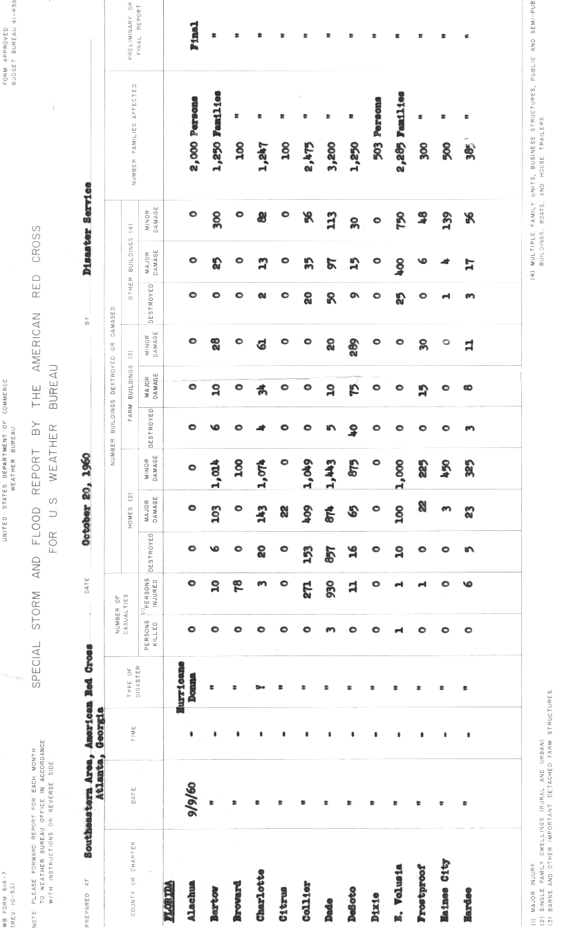
In 1960 the strong winds and coastal flooding of Hurricane Donna combined to destroy 153 homes in Collier County, as well as inflict major damage on 409 more, and damage an additional 1,049.[19] Everglades was hard hit, and two years later, Florida's legislature moved the county seat to East Naples, Florida. In 1965, the state legislature changed the town's name to Everglades City.[4]
Historic buildings[]
Historic buildings in Everglades City include the Old Collier County Courthouse, Bank of Everglades Building, and Everglades Laundry (now the Museum of the Everglades).
Schools[]
- Becket School
- Everglades City School
Libraries[]
References[]
- ^ "2019 U.S. Gazetteer Files". United States Census Bureau. Retrieved July 2, 2020.
- ^ Jump up to: a b "U.S. Census website". United States Census Bureau. Retrieved 2008-01-31.
- ^ Jump up to: a b "Population and Housing Unit Estimates". United States Census Bureau. May 24, 2020. Retrieved May 27, 2020.
- ^ Jump up to: a b "An Act relating to the city of Everglades, Collier county, name; amending chapter 29068, Laws of Florida, 1953, by adding section 1A to change the name of said municipality to Everglades City". Act No. 1524 of 1965.
- ^ "Gulf Coast Visitor Center". National Park Service. Retrieved 5 June 2011.
- ^ "US Gazetteer files: 2010, 2000, and 1990". United States Census Bureau. 2011-02-12. Retrieved 2011-04-23.
- ^ Tebeau 1968:5
- ^ "NOWData - NOAA Online Weather Data". National Oceanic and Atmospheric Administration. Retrieved May 9, 2021.
- ^ "Summary of Monthly Normals 1991-2020". National Oceanic and Atmospheric Administration. Retrieved May 9, 2021.
- ^ "Census of Population and Housing". Census.gov. Retrieved June 4, 2015.
- ^ Tebeau. p. 28.
- ^ Tebeau. pp. 28–33.
- ^ Liefermann.
- ^ Tebeau. pp. 33–5.
- ^ Tebeau. pp. 33, 35.
- ^ Carter. p. 80.
- ^ Turner, Gregg M. (December 1, 1999). Railroads of Southwest Florida. Images of America. Arcadia Publishing.
- ^ "Harrisburg to Everglades City". Abandoned Rails. Retrieved 22 December 2013.
- ^ Special Storm and Flood Report by the American Red Cross for U.S. Weather Bureau. American Red Cross (Report). United States Weather Bureau. October 20, 1960. p. 1. Retrieved September 19, 2013.
- Tebeau, Charlton W. (1968). Man in the Everglades. Coral Gables, Florida: University of Miami Press.
Further reading[]
- Carter, Luther J. (1974). The Florida Experience: Land and Water Policy in a Growth State. The Johns Hopkins University Press. ISBN 0-8018-1646-7.
- Leifermann, Henry. (1988). "Billiards and Redfish In the Everglades". The New York Times. March 13, 1988. Accessed July 5, 2013.
- Tebeau, Charlton W. (1955). The Story of the Chokoloskee Bay Country. University of Miami Press.
External links[]
| Wikimedia Commons has media related to Everglades City, Florida. |
| show Municipalities and communities of Collier County, Florida, United States |
|---|

| show Authority control |
|---|
- Everglades City, Florida
- Cities in Collier County, Florida
- Populated coastal places in Florida on the Gulf of Mexico
- Cities in Florida
- Former county seats in Florida
- 1892 establishments in Florida
- Populated places established in 1892