Fatu-Hiva
This article needs additional citations for verification. (February 2016) |
Fatu-Hiva | |
|---|---|
 Location of the commune (in red) within the Marquesas Islands | |
show Location of Fatu-Hiva | |
| Coordinates: 10°29′00″S 138°38′00″W / 10.4833°S 138.6333°WCoordinates: 10°29′00″S 138°38′00″W / 10.4833°S 138.6333°W | |
| Country | France |
| Overseas collectivity | French Polynesia |
| Subdivision | Marquesas Islands |
| Government | |
| • Mayor (2020–2026) | |
| Area 1 | 85 km2 (33 sq mi) |
| Population (2017) | 612 |
| • Density | 7.2/km2 (19/sq mi) |
| Time zone | UTC−09:30 |
| INSEE/Postal code | 98718 /98740 |
| Elevation | 0–1,125 m (0–3,691 ft) |
| 1 French Land Register data, which excludes lakes, ponds, glaciers > 1 km2 (0.386 sq mi or 247 acres) and river estuaries. | |


Fatu-Hiva (the "H" is not pronounced, see name section below) is the southernmost island of the Marquesas Islands, in French Polynesia, an overseas territory of France in the Pacific Ocean. With Motu Nao as its closest neighbor, it is also the most isolated of the inhabited islands.
Fatu Hiva is also the title of a book by explorer and archaeologist Thor Heyerdahl, in which he describes his stay on the island in the 1930s.
Name[]
The name of the island in Marquesan is Fatu Iva (without "h": [ˈfatu ˈiva]). However, the name was recorded by Europeans as Fatu-Hiva, perhaps under the influence of other Marquesan islands containing the element Hiva (Nuku-Hiva and Hiva-Oa) and also because in French the letter "h" is silent. The spelling Fatu-Hiva has now become official.
The island was named Isla Magdalena ("Magdalene Island") by Spanish explorers in the 16th century, a name rarely used.
Hatauheva is another name that appears in 1817, by Camille de Roquefeuil during his voyage around the world on the "Bordelais".
The name Fatou-Hiva appears in 1838 in a work by Jules Dumont d'Urville.
History[]
First settlers[]
Like the other islands of the archipelago, Fatu Iva was originally populated by Polynesians, who probably came from Western Polynesia.
Rivalries between the different valleys were frequent. In one of them, around the middle of the 19th century, the Anainoapa tribe of Hanavave and the Tiu of Omoa confronted each other. The latter, defeated, fled the island on bamboo rafts and ended up in the Tuamotus, on Napuka Atoll, where their descendants still live. The Tiu sorcerer, who remained on Fatu Iva, revealed to the victors the names of the places in the valley (a way of acknowledging their sovereignty), and had himself buried alive, head down, symbolizing his defeat and the end of his tribe.[1]
Little is known of Fatu Hiva culture before European influence, as it was greatly affected by the arrival of the missionaries. Stratified tribal societies were formed in the great valleys, as in the rest of the Marquesas Islands. In 1897, the German explorer Karl von den Steinen described nine tribes inhabiting the Hanamoohe, Hanateone, Hanahouuna, Ouia, Hanavave and Omoa valleys. In the Hanavave valley, four tribes are known from the stones.
Systematic archaeological excavations have not yet been carried out. Surface investigations were carried out by the American anthropologist Ralph Linton on behalf of the Bishop Museum of Honolulu in 1920-1921. The finds are less numerous than on the other islands of the Marquesas and indicate less extensive building activity. Linton found the remains of several tohua (ceremonial and power centers) with dwelling platforms (paepae) and small me'ae in the Omoa Valley. This led Linton to suspect that several tribes had resided there. During his brief visit to the Hanavave Valley, Linton was only able to find small remains of a tohua and a ceremonial stone platform. Unlike the other islands of the Marquesas, the dead of Fatu Hiva were occasionally mummified (smoked) and often buried in the dwellings.[2]
No colossal stone statues have been found on the island, but some small, crude stone sculptures have been preserved. This does not mean that there were no outstanding works of art on Fatu Hiva in prehistoric times. The island was rather known for tattoo artists and wood carvers, whose ephemeral works have barely survived the ages.
European Exploration and Colonization[]

From a Western perspective, the first explorer to discover Fatu Iva was the Spanish navigator Álvaro de Mendaña, on July 21, 1595. It was the first island in the archipelago that he saw, but he was unable to land there because he could not find a safe anchorage. He mistakenly believed that he had found the Solomon Islands, the goal of his voyage, before realizing that he had just discovered a new land. He named the archipelago "Marquesas de Mendoza", in honor of the viceroy of Peru at the time, who had helped him launch his expedition, "wishing to show his gratitude for the help he had given him "10 As Mendaña arrived during the vigil of St. Mary Magdalene in 1595, he named the place Isla Magdalena.[3][4]
In 1937 and 1938, Norwegian anthropologist and adventurer Thor Heyerdahl and his wife Liv lived for a year and a half in Fatu Iva, first in Omoa and then in Ouia, a now deserted valley on the eastern coast of the island. Officially commissioned by the University of Oslo to investigate the distribution and spread of animal species among the Polynesian islands, his most personal goal on this trip, which was also his wedding trip, was to "sail the South Seas" and never return. The couple landed on Omoa in 1937, but found that civilization was still too much for their liking. They crossed the island and settled in Ouia, on the east coast of the island, a valley formerly inhabited by marqueses. However, after a year and a half, mosquitoes, disease and bad weather dampened their enthusiasm. He recounted his experience in the book Paa Jakt efter Paradiset (1938), rewritten in 1974 and published as Fatu Hiva, the return to nature.[5]
In the early 1960s, until 1966, most of the island's men went to work in Moruroa, in the Tuamotu archipelago, on the construction of the Pacific [Nuclear] Experimental Center.[1]
On March 11, 2011, Swiss explorer Raphaël Domjan, expedition leader of the PlanetSolar adventure, the first ship to circumnavigate the planet on solar power, called at Fatu Hiva.
Geography[]
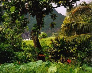
The eastern coastline of Fatu-Hiva is characterized by a number of narrow valleys, carved by streams that lead to the interior. Between these valleys are headlands which terminate in cliffs that plunge directly into the sea, making travel between them possible only by travelling over the high mountain ridges between them, or by boat. The largest of these valleys is at Uia.
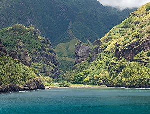
The western coastline has two significant bays, Hana Vave (also known as Bay of Virgins or Baie des Vierges) in the north, one of the most picturesque sites in the South Pacific, and the well-protected harbor of Omoa near the south. There are several smaller valleys between these two.
The center of the island is a plateau which is covered largely by tall grasses and pandanus trees. To the south of the plateau, running to the south, is a mountain ridge, called , its highest peak, at 1,125 m (3,691 ft.) is the highest point on Fatu-Hiva. Proceeding to the north and northwest from the plateau is a mountain ridge called Fa‘e One, the highest peak of which is 820 m (2,690 ft.).
Geology[]
Fatu Hiva is formed by the eastern half of two interlocking volcanoes.
The first caldera, about eight kilometers in diameter, has a sharply cut rim, formed by a hemicircular series of peaks rising to over 1000 meters. It is composed mainly of basalt, picrite and hawaiite. Its age is dated between 2.46 and 1.81 million years. The second caldera, located within the first, has a diameter of three to four kilometers. It was created by a powerful eruption, as evidenced by the impressive basalt columns, the "statues" of the Virgin, in Hanavave Bay, caused by lahars. It dates to between 1.68 and 1.33 million years ago. The main explosion seems to date back to 1.40 Ma2.
The valleys of the two villages of the island are located at the extremes of the space between the two calderas.
Flora[]

The landscape surrounding the settlements in the coastal zone and in the valleys has been extensively remodeled for human food production, so little of the original vegetation remains. Massive interventions, already in historical times, probably caused the extinction of an unknown number of endemic and native plants in the lower and middle areas of the island. The present inhabitants cultivate breadfruit, coconut, yam, taro, sweet potatoes, bananas and other tropical fruits for their own consumption.
The higher areas of the mountainous island are covered with mountain rainforest and cloud forest interspersed with tree ferns. Above 600 m, grass forests (Metrosideros and Weinmannia) dominate. However, even these inaccessible areas are threatened, as feral goats are seriously affecting the flora. Peak tops and extensive leeward areas of the mountains are arid.
The mountain rainforest still harbors some endemic plants, such as Pelea fatuhivensis (syn. Melicope fatuhivensis), which belongs to the ruda family, but may already be extinct. A systematic study of the flora with the support of the Smithsonian Institute in 1988 revealed the number of 175 native, 21 endemic and 136 anthropochoric plants.[6]
Fauna[]
The rich flora contrasts with a relatively species-poor fauna. It is limited to land and sea birds, insects, butterflies, spiders and a single species of bat. The Fatu Hiva monarch (Fatu Hiva monarch or Pomarea whitneyi) of the family Monarchidae is endemic. Because Fatu Hiva is considered rat-free, efforts are underway to relocate endangered landbird species from other islands in the Marquesas. This has been successful, for example, with the ultramarine parrot (Vini ultramarina) of the loris family.
Administration[]
Administratively Fatu-Hiva forms the commune (municipality) of Fatu-Hiva, part of the administrative subdivision of the Marquesas Islands.[7] This commune consists solely of the island of Fatu-Hiva itself.[8] The administrative centre of the commune is the settlement of Omoa,[8] on the south-western side of the island.
Demographics[]
The total population was 584 in the 2002 census, 611 in 2012 and 633 in 2017.[9] The main villages are Omoa, the capital, and Hanavave, located in the bays of the same name. The population lives mainly from agriculture, handicrafts and tourism. The orography of the island does not allow the construction of an airstrip and it is only accessible by boat.
Fatu Hiva has experienced a demographic decline since the late 1990s, mainly due to two types of emigration. The first is "school" emigration: as there is no secondary school on the island, young people are forced to leave at a very young age, first to Hiva Oa and then to Papeete to pursue their studies. Many did not return to Fatu Hiva afterwards.
The second is economic emigration: the island's development prospects are limited by its isolation. It is the most remote of the islands of the archipelago, and has no airstrip, impossible to build because of the rugged terrain. However, since 2007 there has been a demographic recovery, with a 4% increase in five years. primarily spread across three villages:
Religion[]
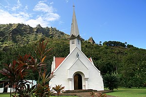
The majority of the population is currently affiliated with Christianity as a result of missionary activity by both Catholic and Protestant groups. The Catholic Church administers two religious buildings on the island under the Diocese of Taiohae (Dioecesis Taiohaënus seu Humanae Telluris or Diocèse de Taiohae). The Church of Saint Michael in Hanavave (Église de Saint-Michel)[10] and the Church of Our Lady of Peace in Omoa (Église de Notre-Dame-de-Paix).[11]
Economy[]
The primary sector is still predominant, especially tuna, mackerel, bonito, swordfish and marlin fishing, as well as crayfish. The municipality has a cold storage facility that allows waiting for the arrival of cargo ships to sell the merchandise. Copra cultivation is still very important, as is the more recent cultivation of noni. Coffee cultivation was practically abandoned in the second half of the 20th century. For their personal needs, the inhabitants also hunt wild pigs and goats, and gather seafood and fruit in great abundance. They do not hesitate to offer fruit spontaneously to visitors.
Since the 1960s and 1970s, handicrafts have developed considerably, thanks mainly to tourism. The specialty of the island is the tapa. Today they are still made in the traditional way, mainly in monochrome. However, chemical dyes are now used instead of soot from the luminous walnut. The currency is (still) the CFP franc, which is pegged to the euro.
The islanders live mainly from subsistence farming. Selling monoi oil, carvings and painted bark raffia to infrequent cruise ship tourists and circumnavigators brings in some money.
Tourism[]
Tourism plays hardly any economic role. A corresponding infrastructure with hotel, restaurants, bank and organized tours is still lacking. Visitors have to rely on modestly equipped private accommodation and a high degree of self-initiative. Fatu Hiva has no bathing beaches. The island is hardly visited by cruise ships.
The three-hour hike between the two villages is strenuous because of the heat, steep climbs and ubiquitous mosquitoes, but it is well worth it and offers spectacular views of the island and the ocean. It also passes an impressive waterfall.
In the home of the Grélet family of Omoa, originally from Switzerland, there is a small private collection of interesting art, cult and utilitarian objects, which is tastefully displayed to infrequent visitors. The collection includes carefully carved stone blades of black basalt, ornate historic weapons, carvings, traditional lid work and small stone figurines. The extensive collection of masterfully ornamented bowls made from rare woods is unique. Pots called koka'a, up to a meter in diameter, were used to serve popoi, a porridge made from breadfruit, which was once the main food of the island and remains an important part of meals today.
Politics and Government[]
Politically, the island belongs to French Polynesia (Pays d'outre-mer - POM) and is therefore affiliated with the European Union. It is administered by a subdivision (Subdivision administrative des Îles Marquises) of the High Commissariat of the Republic in French Polynesia (Haut-commissariat de la République en Polynésie française) based in Papeete. Fatu Hiva forms an independent municipality (Commune de Fatu Hiva) with 636 inhabitants (2012),[12] the population density is about 7 inhabitants/km².
The official language is French. The main town and administrative center is the village of Omoa, on the west coast, with about 250 inhabitants.
Infrastructure[]

The inhabitants of this 8400 hectare island live mainly in the villages of Omoa and Hanavave, on the west coast, which are connected by a dirt road through the mountains. The largest of the villages is Omoa, with a Catholic church, a nursery and elementary school, a small store, a post office and a satellite telephone. Fatu Hiva has no paved roads between the two villages, no harbor dock for large ships, and no airfield. Safe landing on the difficult-to-access coast is only possible in the two bays on the west coast, where the villages are also located.
The seventeen-kilometer road linking the two villages is very bumpy, especially near Hanavave, and the rains often make the road sweeping and dangerous for traffic. The inhabitants prefer to use a boat to reach the other village (a quarter of an hour of navigation is enough).
Fatu Hiva in Literature[]
The island became better known through the book of the same name by Thor Heyerdahl, who spent about eight months on the island in 1937 with his first wife Liv in a self-imposed robinsonade.[13] The couple lived first near the west coast in the Omoa Valley, and later on the east coast in Ouia, which is now uninhabited. In 1937 there was also an old man named Tei Tetua, by his own account the son of one of the last true cannibals, who lived there accompanied by his twelve-year-old adopted daughter.
A first book about the stay was published in 1938 by Gyldendal in Oslo, sold poorly despite the best reviews and was never translated, probably also because of the war. Heyerdahl's well-known book Fatu Hiva was later rewritten, according to the author's note: After the success of his book his first work had become outdated.[14]
In Jack London's short story collection "A Son of the Sun", the island appears under the name Fitu-Iva. In the story "Feathers of the Sun," Fitu-Iva falls under the influence of a cunning Solomon Islands swindler who, with the connivance of the ever-elusive chief, introduces paper money and exchanges all valuables for domestically manufactured currency. When the fraud is discovered, he is beaten with a dead pig, a particularly dishonorable punishment, and banished from the island.[15]
See also[]
References[]
- ^ Jump up to: a b Eve Sivadjian, , Paris, Autrement, coll. « Monde / HS n°16 », 30 septembre 1999, 231 p.
- ^ Ralph Linton: Archaeology of the Marqueas Islands, Bernice P. Bishop Bulletin Nr. 23, Honolulu 1925, S. 181–185
- ^ Annie Baert, « Alvaro de Mendaña (1542-1595), un explorateur du Pacifique sud au destin tragique »
- ^ Sharp, Andrew The discovery of the Pacific Islands Clarendon Press, Oxford, 1960, p.51.
- ^ Thor Heyerdahl (trad. de l'anglais par Aliette Henri Martin), [« Fatu-Hiva Back to Nature »], Papeete, Les Éditions du Pacifique, 1976, 355 p.
- ^ Jacques Florence und David H. Lorence: Introduction to the Flora and Vegetation of the Marquesas Islands. In: Allertonia, Vol. 7, Februar 1997, S. 226–237, ISSN 0735-8032
- ^ Décret n° 2005-1611 du 20 décembre 2005 pris pour l'application du statut d'autonomie de la Polynésie française Archived 2019-03-27 at the Wayback Machine, Légifrance
- ^ Jump up to: a b Décret n°72-407 du 17 mai 1972 portant création de communes dans le territoire de la Polynésie française Archived 2019-12-21 at the Wayback Machine, Légifrance
- ^ Répartition de la population en Polynésie française en 2017 Archived 2018-10-24 at the Wayback Machine, Institut de la statistique de la Polynésie française
- ^ "Église de Saint-Michel". GCatholic. Retrieved 2021-09-10.
- ^ "Église de Notre-Dame-de-Paix". GCatholic. Retrieved 2021-09-10.
- ^ Institut Statistique de Polynésie Française (ISPF) – Recensement de la population 2012
- ^ Thor Heyerdahl: Fatu Hiva – Zurück zur Natur, Bertelsmann-Verlag, München-Gütersloh-Wien; Neuauflage: Goldmann-Verlag. München 1996, ISBN 3-442-08943-3
- ^ Heyerdahl, Fatu Hiva S. 19.
- ^ Jack London: Ein Sohn der Sonne und andere Südseegeschichten (Originaltitel: A Son of the Sun), Universitas-Verlag, Berlin 1926
| Wikimedia Commons has media related to Fatu-Hiva. |
| show Authority control |
|---|
- Islands of the Marquesas Islands
- Communes of French Polynesia