Fenyi County
Fenyi County
分宜县 Feni | |
|---|---|
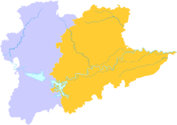 Xinyu is the western division in this map of Xinyu | |
 Xinyu in Jiangxi | |
| Coordinates: 27°48′53″N 114°41′32″E / 27.8148°N 114.6921°ECoordinates: 27°48′53″N 114°41′32″E / 27.8148°N 114.6921°E | |
| Country | People's Republic of China |
| Province | Jiangxi |
| Prefecture-level city | Xinyu |
| Area | |
| • Total | 1,389 km2 (536 sq mi) |
| Population (2019) | 320,500 |
| Time zone | UTC+8 (China Standard) |
| Postal code | 336600 |

Fenyi County (Chinese: 分宜县; pinyin: Fēnyí Xiàn) is a county in the northwest of Jiangxi province, the People's Republic of China. It is under the administration of the prefecture-level city of Xinyu.
The population in 2017 was 316,500.
Administrative divisions[]
In the present,Fenyi County has 6 towns and 4 townships.[1]
- 6 towns
|
|
- 4 townships
|
|
Climate[]
Fenyi Country has a humid subtropical climate with abundant rainfall and sunshine, and a long frost-free period. It has an average yearly temperature of 17.2 degrees, average annual rainfall of 1,600 mm (63 in), and a frost-free period of 270 days.
| showClimate data for Fenyi (1981–2010) |
|---|
References[]
- ^ "南京市-行政区划网 www.xzqh.org" (in Chinese). XZQH. Retrieved 2012-05-24.
- ^ 中国地面气候标准值月值(1981-2010) (in Chinese). China Meteorological Data Service Center. Retrieved 20 October 2018.
External links[]
| show Authority control |
|---|
Categories:
- County-level divisions of Jiangxi