Gan River
| Gan River | |
|---|---|
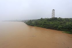 Gan River and Yuhong Pagoda in Ganzhou | |
 | |
| Native name | 赣江 (Chinese) |
| Location | |
| Country | People's Republic of China |
| Province | Jiangxi |
| Physical characteristics | |
| Mouth | |
• location | Lake Poyang |
| Length | 599 km (372 mi) |
| Basin size | 103,183 km2 (39,839 sq mi) |
| Discharge | |
| • average | 2,842 m3/s (100,400 cu ft/s) |
| Basin features | |
| Tributaries | |
| • left | Mei River, Zhang River |
| • right | Gong River |
The Gan River (simplified Chinese: 赣江; traditional Chinese: 贛江; pinyin: Gàn Jiāng, Gan: Kōm-kong) runs north through the western part of Jiangxi before flowing into Lake Poyang and thus the Yangtze River. The Xiang-Gan uplands separate it from the Xiang River of neighboring eastern Hunan.[1]
Two similarly sized rivers, the Gong River which is the southern tributary and the Mei River from the north combine in Yudu County, Jiangxi, to form the Gan. The Gan River flows 527 km (327 mi) before splitting into distributaries just north of Nanchang. The longest of these, the North Branch, is several times longer than the other distributaries at 72 km (45 mi). The Gan River is the major geographical feature of Jiangxi, and gives its name to the Gan variety of Chinese[2] as well as the province's one-character abbreviation.[3]
The river feeds into Lake Poyang, which in turns connects with the Yangtze.[4]
See also[]
- List of rivers in China
- 2010 South China floods
References[]
- ^ Carol Benedict (2011). "Chinese Tobacco Production, 1600 to 1750". Golden-Silk Smoke: A History of Tobacco in China, 1550–2010. University of California Press. p. 41. ISBN 9780520948563.
- ^ James Stuart Olson (1998). An Ethnohistorical Dictionary of China. Greenwood Press. p. 80. ISBN 9780313288531. Retrieved 2 March 2019.
- ^ 高考地理:中国各省份简称历来 (in Chinese). Sohu Education. 2017-07-08. Retrieved 2018-12-17.
19、江西--地处长江中下游南岸,赣江是省内最大的河流,故简称“赣”
- ^ Stephen Turnbull (2002). "A Case Study of Chinese Fighting Ships". Fighting Ships of the Far East (1): China and Southeast Asia 202 BC-AD 1419. Osprey Publishing. p. 37. ISBN 9781782000174.
External links[]
- . Collier's New Encyclopedia. 1921.
Jiangxi topics | |
|---|---|
Nanchang (capital) | |
| General | |
| Geography |
|
| Education | |
| Culture |
|
| Visitor attractions |
|
| |
Coordinates: 28°31′55″N 115°48′54″E / 28.532°N 115.815°E

This Jiangxi location article is a stub. You can help Wikipedia by . |
This article related to a river in China is a stub. You can help Wikipedia by . |
- Rivers of Jiangxi
- Tributaries of the Yangtze River
- Jiangxi geography stubs
- China river stubs