Huangpu River
| Huangpu River Pu Jiang (浦江) Chunshen Jiang (春申江) Shen Jiang (申江) | |
|---|---|
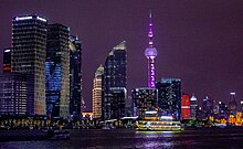
 A view of the Huangpu River as it flows through downtown Shanghai. | |
 Location of mouth in Shanghai | |
| Native name | 黄浦江 |
| Location | |
| Country | China |
| Municipality | Shanghai |
| Physical characteristics | |
| Source | Dianshan Lake |
| • location | Qingpu, Shanghai, China |
| Mouth | Yangtze River |
• location | Baoshan, Shanghai, China |
| Length | 113 km (70 mi) |
| Discharge | |
| • average | 180 m3/s (6,400 cu ft/s)[1] |
| Basin features | |
| Tributaries | |
| • left | Suzhou Creek |
| Huangpu River | |||
|---|---|---|---|
| Simplified Chinese | 黄浦江 | ||
| Traditional Chinese | 黃浦江 | ||
| Postal | Whangpoo River | ||
| |||
The Huangpu (![]() pronunciation (help·info)), formerly romanized as Whangpoo,[2] is a manmade 113-kilometer-long (70 mi) river flowing north through Shanghai that was first excavated and created by Lord Chunshen, one of the Four Lords of the Warring States. It is the last significant tributary of the Yangtze before the Yangtze empties into the East China Sea. The Bund and Lujiazui are located along the Huangpu River.
pronunciation (help·info)), formerly romanized as Whangpoo,[2] is a manmade 113-kilometer-long (70 mi) river flowing north through Shanghai that was first excavated and created by Lord Chunshen, one of the Four Lords of the Warring States. It is the last significant tributary of the Yangtze before the Yangtze empties into the East China Sea. The Bund and Lujiazui are located along the Huangpu River.

The Huangpu is the largest river in central Shanghai, with the Suzhou Creek being its major tributary. It is on average 400 meters (1,312 ft) wide and 9 meters (30 ft) deep, and divides the city into two regions: Puxi ("west of Huangpu"), the traditional city center, and Pudong ("east of Huangpu").[3]
Bridges[]
- Fengpu Bridge
- Lupu Bridge, opened 2003.
- Minpu Bridge
-
- The lower deck of this bridge carries Line 5 across the Huangpu River. This is the first line of the Shanghai Metro to cross the river via a bridge.[4]
- Nanpu Bridge, opened 1991.
- Songpu Bridge, opened 1975 railway, 1976 highway.
- Xupu Bridge, opened 1997.
- Yangpu Bridge, opened 1993.
The following roadways, highways, and railways also cross the Huangpu River via a bridge:
- G1503 Shanghai Ring Expressway
- G50 Shanghai–Chongqing Expressway
- G60 Shanghai–Kunming Expressway
- Shanghai–Hangzhou railway
Tunnels[]
A number lines of the Shanghai Metro cross underneath the river, including Line 12, Line 4, Line 2, Line 9, Line 4 (twice), Line 8, Line 13, and Line 11 (from north to south geographically).
There are several roadways which cross the Huangpu River via a tunnel, including:
- Bund Sightseeing Tunnel
- (planned)
- (planned)
- (planned)
- (planned)
- (planned)
- (under construction)
- (planned)
- (planned)
Ferries[]
There are currently several ferry lines operated by Shanghai Ferry. Numerous tour boats also ply the harbour in the Pudong area.
See also[]
| Wikimedia Commons has media related to Huangpu River. |
- Geography of China
- List of rivers in China
References[]
Citations[]
- ^ (四)水文 (in Chinese)
- ^ Sladen (1895), p. 278.
- ^ "The New Huangpu River Both Banks". Archived from the original on 2014-04-13. Retrieved Apr 16, 2014.
- ^ "Shanghai Metro Line 5 South Extension to Start Test Runs". that's Shanghai. 10 August 2018. Retrieved 15 June 2020.
Bibliography[]
- Sladen, Douglas (1895), "Bits of China", The Japs at Home, 5th ed., New York: New Amsterdam Book Co., pp. 276–354.
| show Authority control |
|---|
Coordinates: 31°23′19.72″N 121°30′55.12″E / 31.3888111°N 121.5153111°E

- Rivers of Shanghai
- Tributaries of the Yangtze River