Ziya River
This article does not cite any sources. (April 2017) |
| Ziya River Ziya He | |
|---|---|
 | |
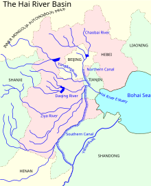 Ziya River in Hai River basin | |
| Native name | 子牙河 |
| Location | |
| Country | China |
| State | Shanxi, Hebei, Tianjin |
| Physical characteristics | |
| Source | Wutai Mountains |
| Mouth | Hai River and Bohai Sea |
| Length | 730 km (450 mi) |
| Basin size | 78,700 km2 (30,400 sq mi) |
| Discharge | |
| • average | 1 m3/s (35 cu ft/s) |
| Ziya River | |||||||||
|---|---|---|---|---|---|---|---|---|---|
| Chinese | 子牙河 | ||||||||
| Literal meaning | River | ||||||||
| |||||||||
The Ziya River is one of the five major tributaries of Hai River system in northern China. The total length of Ziya River is 730 km (450 mi) and the size of its drainage basin is 78,700 square kilometers (30,400 sq mi). The discharge rate of Ziya River is about 1 m3/s.
The Ziya River flows from Mount Wutai until it reaches the Hai River near Xian County. Notable tributaries of the Ziya include the Ming, the Hutuo, the , and the . It shares the same channel with the Hai near the . A new artificial channel was constructed to connect it to Bohai Sea near Tianjin under the name .
References[]
This China-related article is a stub. You can help Wikipedia by . |
Categories:
- China stubs
- Rivers of Hebei
- Rivers of Shanxi