Gangabal Lake
| Gangabal Lake | |
|---|---|
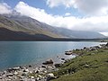
 Gangbal Lake at the foot of Harmukh | |
 Gangabal Lake Location Jammu and Kashmir | |
| Location | Ganderbal, Kashmir Valley |
| Coordinates | 34°25′50″N 74°55′30″E / 34.43056°N 74.92500°ECoordinates: 34°25′50″N 74°55′30″E / 34.43056°N 74.92500°E |
| Type | oligotrophic lake |
| Primary inflows | Melting glaciers |
| Primary outflows | Nundkol Lake which drains into Sind River |
| Basin countries | India |
| Max. length | 2.7 kilometres (1.7 mi) |
| Max. width | 1 kilometre (0.62 mi) |
| Surface elevation | 3,575 metres (11,729 ft) |
| Frozen | November to April |

The Gangabal Lake also called Gangbal Lake, is a lake situated at the foothills of Mount Haramukh (the second highest mountain peak in the vicinity of Kashmir valley)[1] in Ganderbal district, north of Srinagar, in Jammu and Kashmir. It is an alpine high altitude oligotrophic lake,[2] home to many species of fish,[3] including the brown trout.[4]
The lake has a maximum length of two and a half kilometers and maximum width of one kilometre. It is fed by precipitation, glaciers and springs. The lake water outflows to a nearby Nundkol Lake[5] and then via Wangath Nallah[6] to Sind River.[7][8]
Access[]
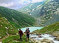
The Gangbal lake is approached from Srinagar 45 kilometers by road via Ganderbal up to Naranag and then a trek of 15 kilometers upslope leads to the lake, which can be covered by a horse ride or by foot. The gujjar shepherds can be seen during the trek with their flocks of sheep and goats. Another trek (25 kilometers long) leads to the lake site from Sonamarg via the Vishansar Lake crossing three mountain passes Nichnai pass, Gadsar pass and Zajibal pass of an average elevation of 4100 meters.[9] It can also be accessed through a trek from Bandipore via Arin.[10] The trek to the lake Gangabal takes place in an alpine environment, (cut crossing) with meadows, (cut from) and huts of Gujjars with their herds crossing through two passes over 4,000 m to get to the lake Gangabal.
Gallery[]


References[]
- ^ "Trekking Kashmir". gaffarakashmir.in. Archived from the original on 13 March 2013. Retrieved 19 April 2012.
- ^ Raina, HS; KK Vass (May–June 2006). "Some biological features of a freshwater fairy shrimp, Branchinecta schantzi, Mackin, 1952 in the Northwestern Himalayas, India" (PDF). J. Indian Inst. Sci. 86: 287–291. Retrieved 21 February 2012.[permanent dead link]
- ^ "Fishes and Fisheries in high altitude lakes, Vishansar, Gadsar, Gangbal, Krishansar". Fao.org. Retrieved 19 April 2012.
- ^ Petr, ed. by T. (1999). Fish and fisheries at higher altitudes : Asia. Rome: FAO. p. 72. ISBN 92-5-104309-4.CS1 maint: extra text: authors list (link)
- ^ "Harmukh Gangbal". kashmirfirst.com. Retrieved 22 May 2012.
- ^ "Indus projects". nih.ernet.net. Archived from the original on 10 July 2015. Retrieved 22 May 2012.
- ^ Raina, Maharaj Krishen. "Know Your Motherland – Gangabal Lake".
- ^ "Kashmir tourism". public.fotki.com. Retrieved 22 May 2012.
- ^ "Track to Gangabal". pttindia.com. Archived from the original on 29 March 2012. Retrieved 22 May 2012.
- ^ "Tracks of Kashmir". kashmirmount.org. Archived from the original on 25 April 2012. Retrieved 22 May 2012.
| Passes |
|  |
|---|---|---|
| Valleys | ||
| Cities | ||
| Towns |
| |
| Rivers | ||
| Glaciers |
| |
| Lakes | ||
| Mountains | ||
| Hill stations and Mughal gardens | ||
| Protected Areas | ||
| See also | ||
- Lakes of Jammu and Kashmir
- Geography of Ganderbal district
- Tourist attractions in Ganderbal district