Shingo River
This article needs additional citations for verification. (February 2020) |
| Shingo River | |
|---|---|
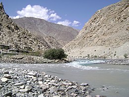 Shingo river (blue) meeting the Dras river in Dalunang | |
 | |
| Location | |
| Countries | Pakistan, India |
| Provinces | Gilgit-Baltistan, Ladakh |
| Physical characteristics | |
| Source | Chota Deosai Plains |
| • location | Astore District, Gilgit-Baltistan, Pakistan |
| • coordinates | 34°53′29″N 75°06′46″E / 34.8913°N 75.1129°E |
| Mouth | 34°35′41″N 76°07′13″E / 34.5946°N 76.1202°ECoordinates: 34°35′41″N 76°07′13″E / 34.5946°N 76.1202°E |
• location | Suru River at Kharul, Kargil district, India |
| Basin features | |
| Progression | Dras River |
| Tributaries | |
| • left | Shigar River |

The Shingo River is a tributary of the Indus River, and flows through Gilgit-Baltistan and Kargil regions.
In the Kashmiri terminology, the Shingo river joins the Dras River, which in turns joins the Suru River. In the Balti terminology, the Shingo River runs all the way to the Indus River, and the other rivers are its tributaries.
Course[]
The river originates in the Chhota Deosai plains in the Astore District, north of Minimarg, and flows east. The Shigar River, which originates in the Bara Deosai Plateau to the north, also flows east and joins the Shingo River before it enters the Indian-administered Kargil district near Dalunang. In the Kargil district, at the Kaksar village, Shingo is joined by the Dras River, which originates near Zojila Pass and flows northeast. The flow of Shingo is then doubled. The two combined rivers join the Suru River flowing north at Kharul, 7 km north of Kargil.
The Suru river flows north into the Skardu District of Baltistan. (The Baltis continue to call the Suru River by the name Shingo.) The river joins the Indus from the left near Olding.[1]
The Shingo river is clearer than other rivers in Ladakh because it is formed from melting ice. It flows through Chanigund.[citation needed]
Environment[]
The Shingo River runs north of the Line of Control dividing the Indian- and Pakistani-administered portions of Kashmir. Gultari is the largest city on its course. A road runs parallel to the river, which once connected Astor to Kargil. Once in the Kargil district, the valley of the Shingo–Drass river contains India's National Highway 1 that connects the Kashmir Valley and Ladakh. After reentering Baltistan, its valley supports the Shingo River Road, which is also called the Kargil–Skardu Road.
References[]
- ^ Kapadia, Harish (1999), Across Peaks & Passes in Ladakh, Zanskar & East Karakoram, Indus Publishing, pp. 226–, ISBN 978-81-7387-100-9
External links[]
- Shingo River marked on OpenStreet
- Suru River basin on OpenStreetMap, including the Shingo and Shigar rivers
- Rivers of Ladakh
- Indus basin
- Rivers of Gilgit-Baltistan
- Astore District
- Skardu District
- Kargil district
- Rivers of Pakistan
- Rivers of India