Shigar River
This article needs additional citations for verification. (January 2021) |
| Shigar River | |
|---|---|
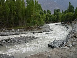 Shigar river at Shigar Fort | |
 | |
| Location | |
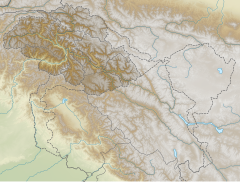
| Country | Pakistan |
| Province | Gilgit-Baltistan |
| Physical characteristics | |
| Mouth | |
• location | Indus River |
• coordinates | 35°19′52″N 75°38′0″E / 35.33111°N 75.63333°E |


Shigar River (Urdu: دریائے شگر) is located in the mountainous Baltistan region of northern Pakistan. The Shigar River is formed from the melted water of the Baltoro Glacier and Biafo Glacier. It flows through the Shigar Valley. The river is tributary to Indus River and meets the Indus in Skardu Valley.[1]
References[]
- ^ "Indus River | Definition, Length, Map, History, & Facts". Encyclopedia Britannica. Retrieved 2020-11-25.
External links[]
![]() Media related to Shigar River at Wikimedia Commons
Coordinates: 35°19′52″N 75°38′0″E / 35.33111°N 75.63333°E
Media related to Shigar River at Wikimedia Commons
Coordinates: 35°19′52″N 75°38′0″E / 35.33111°N 75.63333°E
| Authority control |
|---|
This Gilgit-Baltistan location article is a stub. You can help Wikipedia by . |
Categories:
- Tributaries of the Indus River
- Baltistan
- Rivers of Gilgit-Baltistan
- Karakoram
- Shigar District
- Gilgit-Baltistan geography stubs
- Asia river stubs
- Pakistan geography stubs