Gilgit River
| Gilgit River | |
|---|---|
 | |
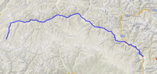 Course of the Gilgit | |
| Native name | دریائے گلگت (Urdu) |
| Location | |
| Country | Pakistan |
| Autonomous Territory | Gilgit-Baltistan |
| Districts | Gupis-Yasin, Ghizer and Gilgit |
| Physical characteristics | |
| Mouth | |
• coordinates | 35°44′31″N 74°37′29″E / 35.74194°N 74.62472°ECoordinates: 35°44′31″N 74°37′29″E / 35.74194°N 74.62472°E |
| Length | 240 km |
| Basin features | |
| Waterbodies | Shandur Lake, Phander Lake, Attabad Lake |

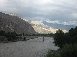
The Gilgit River (Urdu: دریائے گلگت; also referred to as the Ghizer River) is a tributary of the Indus River, and flows through the Gupis-Yasin, Ghizer and Gilgit districts of Gilgit-Baltistan. The upper sections of the river are called Gupis River and Ghizer River. The Gilgit River starts from Shandur Lake,[1] joins the Indus River at junction point of three mountains ranges near towns of Juglot and Bunji.[2][3]

The Gilgit River is a tributary of the Indus River
See also[]
References[]
- ^ isbn:1483603792 - Cerca con Google (in Italian).
- ^ Handy, Norman (2017). K2, The Savage Mountain: Travels in Northern Pakistan. novum pro Verlag. ISBN 9783990487174.
- ^ Dani, Ahmad Hasan; Masson, Vadim Mikhaĭlovich (2003). History of Civilizations of Central Asia: Development in contrast : from the sixteenth to the mid-nineteenth century. UNESCO. ISBN 9789231038761.
| Wikimedia Commons has media related to Gilgit River. |
| Authority control |
|---|
Categories:
- Tributaries of the Indus River
- Rivers of Gilgit-Baltistan
- Karakoram
- Rivers of Pakistan
- Asia river stubs
- Pakistan geography stubs