Genillé
show This article may be expanded with text translated from the corresponding article in French. (March 2016) Click [show] for important translation instructions. |
Genillé | |
|---|---|
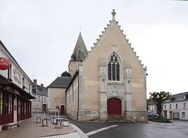 The church of Sainte-Eulalie, in Genillé | |
 Coat of arms | |
show Location of Genillé | |
 Genillé | |
| Coordinates: 47°11′11″N 1°05′46″E / 47.1864°N 1.0961°ECoordinates: 47°11′11″N 1°05′46″E / 47.1864°N 1.0961°E | |
| Country | France |
| Region | Centre-Val de Loire |
| Department | Indre-et-Loire |
| Arrondissement | Loches |
| Canton | Loches |
| Intercommunality | CC Loches Sud Touraine |
| Government | |
| • Mayor (2020–2026) | Henri Alfandari |
| Area 1 | 63.12 km2 (24.37 sq mi) |
| Population (Jan. 2018)[1] | 1,515 |
| • Density | 24/km2 (62/sq mi) |
| Time zone | UTC+01:00 (CET) |
| • Summer (DST) | UTC+02:00 (CEST) |
| INSEE/Postal code | 37111 /37460 |
| Elevation | 71–144 m (233–472 ft) |
| 1 French Land Register data, which excludes lakes, ponds, glaciers > 1 km2 (0.386 sq mi or 247 acres) and river estuaries. | |


Genillé (French pronunciation: [ʒənije]) is a commune in the Indre-et-Loire department in central France.
Geography[]
The village lies in the middle of the commune, on the right bank of the Indrois, which flows northwest through the middle of the commune and forms parts of its eastern and western borders.
Population[]
| Year | Pop. | ±% |
|---|---|---|
| 1793 | 1,850 | — |
| 1800 | 1,942 | +5.0% |
| 1806 | 1,916 | −1.3% |
| 1821 | 1,988 | +3.8% |
| 1831 | 1,954 | −1.7% |
| 1836 | 1,943 | −0.6% |
| 1841 | 1,912 | −1.6% |
| 1846 | 2,008 | +5.0% |
| 1851 | 2,063 | +2.7% |
| 1856 | 2,006 | −2.8% |
| 1861 | 2,043 | +1.8% |
| 1866 | 2,130 | +4.3% |
| 1872 | 2,087 | −2.0% |
| 1876 | 2,242 | +7.4% |
| 1881 | 2,276 | +1.5% |
| 1886 | 2,433 | +6.9% |
| 1891 | 2,325 | −4.4% |
| 1896 | 2,202 | −5.3% |
| 1901 | 2,132 | −3.2% |
| 1906 | 2,097 | −1.6% |
| 1911 | 2,017 | −3.8% |
| 1921 | 1,772 | −12.1% |
| 1926 | 1,850 | +4.4% |
| 1931 | 1,718 | −7.1% |
| 1936 | 1,665 | −3.1% |
| 1946 | 1,737 | +4.3% |
| 1954 | 1,647 | −5.2% |
| 1962 | 1,559 | −5.3% |
| 1968 | 1,585 | +1.7% |
| 1975 | 1,417 | −10.6% |
| 1982 | 1,413 | −0.3% |
| 1990 | 1,428 | +1.1% |
| 1999 | 1,425 | −0.2% |
| 2006 | 1,507 | +5.8% |
| 2009 | 1,554 | +3.1% |
See also[]
References[]
- ^ "Populations légales 2018". INSEE. 28 December 2020.
| Wikimedia Commons has media related to Genillé. |
| show Authority control |
|---|
This Indre-et-Loire geographical article is a stub. You can help Wikipedia by . |
Categories:
- Communes of Indre-et-Loire
- Indre-et-Loire geography stubs