Sennevières
Sennevières | |
|---|---|
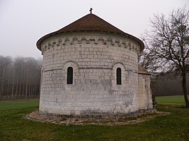 The chapel of Saint-Jean of Liget | |
show Location of Sennevières | |
 Sennevières | |
| Coordinates: 47°06′25″N 1°06′10″E / 47.1069°N 1.1028°ECoordinates: 47°06′25″N 1°06′10″E / 47.1069°N 1.1028°E | |
| Country | France |
| Region | Centre-Val de Loire |
| Department | Indre-et-Loire |
| Arrondissement | Loches |
| Canton | Loches |
| Intercommunality | CC Loches Sud Touraine |
| Government | |
| • Mayor (2020–2026) | Caroline Krier[1] |
| Area 1 | 23.54 km2 (9.09 sq mi) |
| Population (Jan. 2018)[2] | 208 |
| • Density | 8.8/km2 (23/sq mi) |
| Time zone | UTC+01:00 (CET) |
| • Summer (DST) | UTC+02:00 (CEST) |
| INSEE/Postal code | 37246 /37600 |
| Elevation | 91–149 m (299–489 ft) |
| 1 French Land Register data, which excludes lakes, ponds, glaciers > 1 km2 (0.386 sq mi or 247 acres) and river estuaries. | |


Sennevières (French pronunciation: [sɛn(ə)vjɛʁ]) is a commune in the Indre-et-Loire department in central France.
Population[]
|
|
See also[]
References[]
- ^ "Répertoire national des élus: les maires". data.gouv.fr, Plateforme ouverte des données publiques françaises (in French). 2 December 2020.
- ^ "Populations légales 2018". INSEE. 28 December 2020.
| Wikimedia Commons has media related to Sennevières. |
This Indre-et-Loire geographical article is a stub. You can help Wikipedia by . |
Categories:
- Communes of Indre-et-Loire
- Indre-et-Loire geography stubs